RSS feed source: Volcano Discovery.com--Global earthquake monitor

Tue, 29 Apr 2025, 04:16 | BY: EARTHQUAKEMONITOR

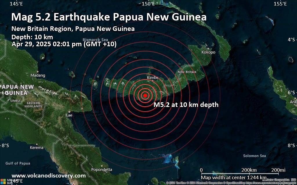
The German Research Centre for Geosciences (GFZ) reported a magnitude 5.2 quake in Papua New Guinea near Kimbe, Talasea District, West New Britain Province, only 14 minutes ago. The earthquake hit early afternoon on Tuesday, April 29th, 2025, at 2:01 pm local time at a shallow depth of 10. km. The exact magnitude, epicenter, and depth of the quake might be revised within the next few hours or minutes as seismologists review data and refine their calculations, or as other agencies issue their report.
Our monitoring service identified a second report from France’s Réseau National de Surveillance Sismique (RéNaSS) which listed the quake at magnitude 5.1. Other agencies reporting the same quake include Indonesia’s Meteorology, Climatology, and Geophysical Agency at magnitude 5.2, the European-Mediterranean Seismological Centre (EMSC) at magnitude 5.2, and the citizen-seismograph network of RaspberryShake at magnitude 5.1.
Based on the preliminary seismic data, the quake was probably felt by many people in the area of the epicenter. It should not have caused significant damage, other than objects falling from shelves, broken windows, etc.
In Kandrian (pop. 1000) located 37 km from the epicenter, the quake should have been felt as light shaking.
Weak shaking might have been felt in Kimbe (pop. 18,800) located 69 km from the epicenter.
VolcanoDiscovery will automatically update magnitude and depth if

Click this link to continue reading the article on the source website.

RSS feed source: Volcano Discovery.com--Global earthquake monitor

At 1114 PM CDT, Doppler radar was tracking strong thunderstorms along a line extending from near Stephenson to 8 miles southwest of Marinette to 6 miles northeast of Pulaski. Movement was east at 50 mph. HAZARD…Wind gusts up to 50 mph and half inch hail. SOURCE…Radar indicated. IMPACT…Gusty winds could knock down tree limbs and blow around unsecured objects. Minor hail damage to vegetation is possible. Strong thunderstorms will be near… Marinette and Oconto around 1120 PM CDT. Egg Harbor around 1140 PM CDT. Ephraim around 1145 PM CDT. Sturgeon Bay around 1150 PM CDT. Other locations impacted by these storms include Cullen, Peninsula State Park, Valmy, Sobieski, Whitefish Bay, South

Click this link to continue reading the article on the source website.

RSS feed source: Volcano Discovery.com--Global earthquake monitor

At 1111 PM CDT, a severe thunderstorm was located over Gaines County Airport, or near Seminole, moving northeast at 45 mph. HAZARD…60 mph wind gusts and half dollar size hail. SOURCE…Quarter size hail was reported near Seminole by the public. IMPACT…Hail damage to vehicles is expected. Expect wind damage to roofs, siding, and trees. Locations impacted include… Seminole, Seagraves, Seagraves Airport, Gaines County Airport, Welch, Loop, Florey, Frankel City, Punkin Center, Paynes Corner, McKenzie Lake, and Gaines County Park.

Click this link to continue reading the article on the source website.

RSS feed source: Volcano Discovery.com--Global earthquake monitor

* WHAT…Flooding caused by excessive rainfall is expected. * WHERE…A portion of central Oklahoma, including the following counties, Cleveland and McClain. * WHEN…Until 115 AM CDT. * IMPACTS…Minor flooding in low-lying and poor drainage areas. * ADDITIONAL DETAILS… – At 1110 PM CDT, Doppler radar indicated heavy rain due to thunderstorms. Minor flooding is ongoing or expected to begin shortly in the advisory area. Between 0.1 and 0.2 inches of rain have fallen. – Additional rainfall amounts of 0.5 to 0.6 inches are expected over the area. This additional rain will result in minor flooding. – Some locations that will experience flooding include… Southern Oklahoma City, Norman, Moore, Newcastle, Blanchard, Noble,

Click this link to continue reading the article on the source website.