RSS feed source: US National Weather Service

* WHAT…Urban and small stream flooding caused by excessive rainfall is expected. * WHERE…Northern Navarro County * WHEN…Until 230 PM CDT. * IMPACTS…Minor flooding in low-lying and poor drainage areas. Some low-water crossings may become impassable. * ADDITIONAL DETAILS… – Doppler radar indicated heavy rain due to thunderstorms. This will likely cause urban and small stream flooding. Low lying and/or poor drainage areas will experience minor flooding in the advisory area. Between 1 and 2 inches of rain have fallen. Additional rainfall amounts of 1 to 2 inches are forecast. – Some locations that will experience flooding include… Corsicana, Kerens, Trinidad, Blooming Grove, Dawson, Angus, Barry, Navarro, Lake Halbert, Navarro Mills

Click this link to continue reading the article on the source website.

RSS feed source: US National Weather Service

Thu, 24 Apr 2025, 16:20 | BY: EARTHQUAKEMONITOR

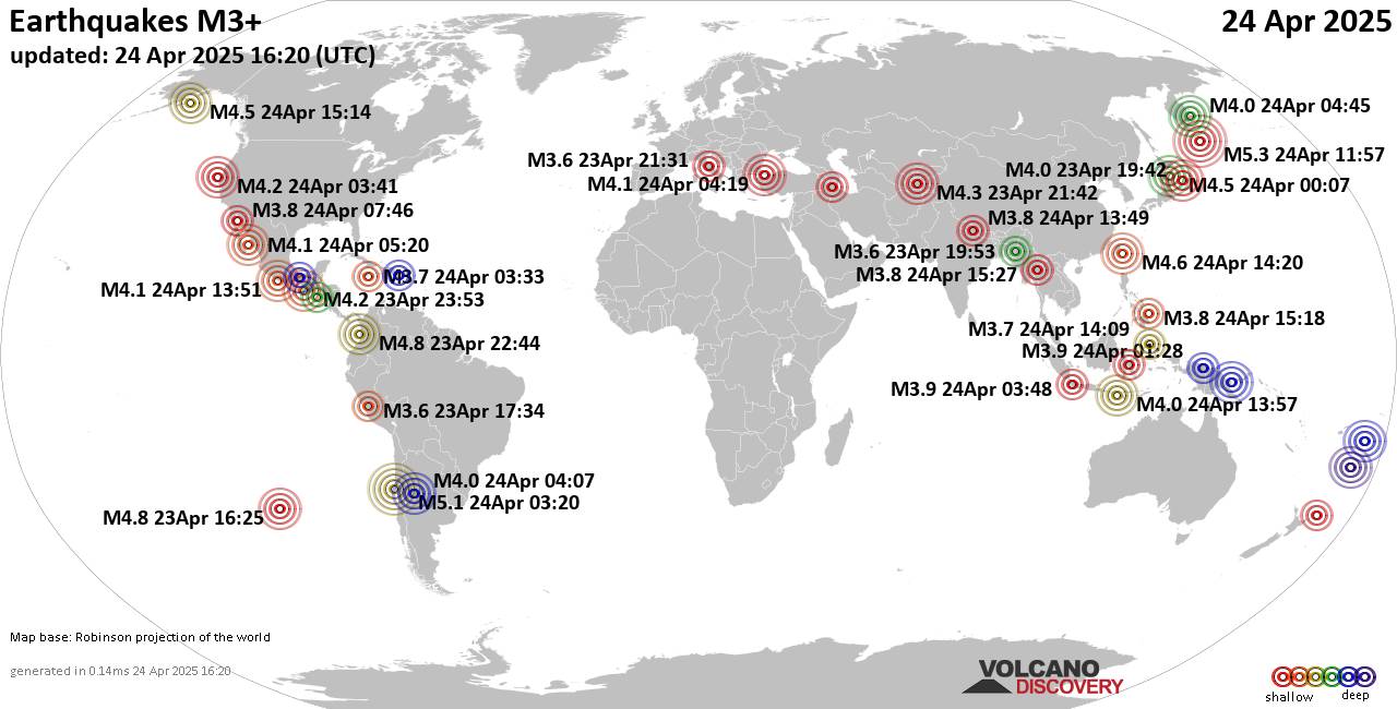
Worldwide earthquakes above magnitude 3 during the past 24 hours on 24 Apr 2025

Summary: 2 quakes 5.0+, 36 quakes 4.0+, 166 quakes 3.0+, 420 quakes 2.0+ (624 total)
This report is being updated every hour.
Magnitude 5+: 2 earthquakes
Magnitude 4+: 36 earthquakes
Magnitude 3+: 166 earthquakes
Magnitude 2+: 420 earthquakes
No quakes of magnitude 6 or higherTotal seismic energy estimate: 2.1 x 10¹³ joules (5.82 gigawatt hours, equivalent to 5005 tons of TNT or 0.3 atomic bombs!) | equivalent to ONE quake of magnitude 5.7 learn more10 largest earthquakes in the world (past 24 hours)#1: Mag 5.3 North Pacific Ocean, 223 km east of Ostrov Onekotan Island, Sakhalin Oblast, RussiaThursday, Apr 24, 2025, at 10:57 pm (GMT +11) – #2: Mag 5.1 South Pacific Ocean, 66 km west of Ovalle, Provincia de Limari, Region de Coquimbo, ChileWednesday, Apr 23, 2025, at 11:20 pm (Santiago time) – #3: Mag 4.9 South Pacific Ocean, 34 km west of Tofua Island, Ha`apai, TongaThursday, Apr 24, 2025, at 10:57 am (GMT +13) – #4: Mag 4.8 North Pacific Ocean, 46 km southwest of Pizarro, ColombiaWednesday, Apr 23, 2025, at 05:44 pm (GMT -5) – #5: Mag 4.8 Southeast of Easter IslandWednesday, Apr 23, 2025, at 09:25 am (GMT -7) – #6: Mag 4.8 68 km northeast of Lae, Morobe, Papua New GuineaThursday, Apr 24,

Click this link to continue reading the article on the source website.
RSS feed source: US National Weather Service

…The National Weather Service in Milwaukee/Sullivan WI has issued a Flood Warning for the following rivers in Wisconsin… Wisconsin River At Portage affecting Columbia County. * WHAT…Minor flooding is forecast. * WHERE…Wisconsin River at Portage. * WHEN…Until early Saturday morning. * IMPACTS…At 17.0 feet, There is general overflow of the river. Water is near homes in the Blackhawk Park area of Portage on the south side of the river along Old River Road. Floodwaters are over West Lake Road and Blackhawk Road in the Blackhawk Park area. * ADDITIONAL DETAILS… – At 9:00 AM CDT Thursday the stage was 16.8 feet. – Bankfull stage is 12.7 feet. – Forecast…The river is

Click this link to continue reading the article on the source website.

RSS feed source: US National Weather Service

Date and TimeMag
DepthDistanceLocationDetailsMap Apr 22, 08:38 pm (GMT +9)

3.9

60 km56 km (35 mi) to the S North Pacific Ocean, 97 km southeast of Sendai, Miyagi-ken, JapanI FELT IT

Info

Apr 22, 08:37 pm (GMT +9)

3.8

56 km55 km (34 mi) to the S North Pacific Ocean, 96 km southeast of Sendai, Miyagi-ken, JapanI FELT IT

Info

Apr 22, 08:37 pm (GMT +9)

3.9

61 km53 km (33 mi) to the S North Pacific Ocean, 92 km southeast of Sendai, Miyagi-ken, JapanI FELT IT

Info

Apr 22, 07:23 pm (GMT +9)

3.6

98 km74 km (46 mi) to the W 13 km north of Sendai, Miyagi-ken, JapanI FELT IT

Info

Apr 22, 01:48 am (GMT +9)

4.5

45 km95 km (59 mi) to the S North Pacific Ocean, 60 km east of Minami-Soma, Fukushima, JapanI FELT IT2 reportsInfoMar 30, 09:31 pm (GMT +9)

4.2

40 km57 km (35 mi) to the NE North Pacific Ocean, 88 km east of Ishinomaki, Miyagi-ken, Japan InfoMar 30, 09:30 pm (GMT +9)

4.2

40 km58 km (36 mi) to the NE North Pacific Ocean, 77 km southeast of Ofunato, Iwate, Japan InfoMar 16, 2022 11:36 pm (GMT +9)

7.3

41 km66 km (41 mi) to the S 57 km ENE of Namie, Japan 101 reportsInfoMay 1, 2021 10:27 am (GMT +9)

6.7

61 km14 km (8.7 mi) to the SW Near East Coast of Honshu, Japan 98 reportsInfoMar 20, 2021 06:09 pm (GMT +9)

6.9

44 km35 km (22 mi) to the NW 16 km northeast of Ishinomaki, Miyagi-ken, Japan 218 reportsInfoFeb 13, 2021 11:07 pm (GMT +9)

7.0

56 km64 km (40 mi) to the

Click this link to continue reading the article on the source website.