RSS feed source: Volcano Discovery.com--Global earthquake monitor

Sat, 12 Apr 2025, 14:20 | BY: EARTHQUAKEMONITOR

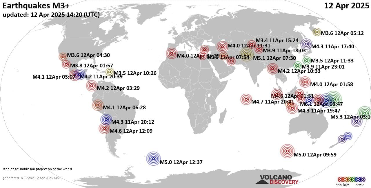
Worldwide earthquakes above magnitude 3 during the past 24 hours on 12 Apr 2025

Summary: 1 quake 6.0+, 5 quakes 5.0+, 24 quakes 4.0+, 135 quakes 3.0+, 384 quakes 2.0+ (549 total)
This report is being updated every hour.
Magnitude 6+: 1 earthquake
Magnitude 5+: 5 earthquakes
Magnitude 4+: 24 earthquakes
Magnitude 3+: 135 earthquakes
Magnitude 2+: 384 earthquakes
No quakes of magnitude 7 or higherTotal seismic energy estimate: 1.1 x 10¹⁴ joules (31 gigawatt hours, equivalent to 26664 tons of TNT or 1.7 atomic bombs!) | equivalent to ONE quake of magnitude 6.2 learn more10 largest earthquakes in the world (past 24 hours)#1: Mag 6.1 South Pacific Ocean, 85 km southwest of Ambitle Island, Papua New GuineaSaturday, Apr 12, 2025, at 01:47 pm (Port Moresby time) – #2: Mag 5.3 South Pacific Ocean, 369 km north of Tofua Island, Ha`apai, TongaSaturday, Apr 12, 2025, at 04:16 pm (GMT +13) – #3: Mag 5.1 Khyber Pakhtunkhwa, 40 km northwest of Islamabad, Islamabad, PakistanSaturday, Apr 12, 2025, at 12:30 pm (Karachi time) – #4: Mag 5.0 South Atlantic Ocean, 88 km northwest of Visokoi Island, South Georgia and the South Sandwich IslandsSaturday, Apr 12, 2025, at 10:37 am (GMT -2) – #5: Mag 5.0 Western Indian-Antarctic RidgeSaturday, Apr 12, 2025, at 05:59 pm (GMT +8) – #6: Mag 5.0 Bismarck Sea, 68 km southwest

Click this link to continue reading the article on the source website.

RSS feed source: Volcano Discovery.com--Global earthquake monitor

* WHAT…Sub-freezing temperatures as low as 32 possible. * WHERE…Dawson, Fannin, Gilmer, Lumpkin, Union, Towns, and White Counties. * WHEN…From late tonight through Sunday morning. * IMPACTS…Frost and freeze conditions could kill crops, other sensitive vegetation and possibly damage unprotected outdoor plumbing.

Click this link to continue reading the article on the source website.

RSS feed source: Volcano Discovery.com--Global earthquake monitor

…The Flood Warning continues for the following river in Arkansas… Black River At Black Rock affecting Jackson, Independence and Lawrence Counties. For the Black River…including Corning, Pocahontas, Black Rock… Moderate flooding is forecast. * WHAT…Moderate flooding is occurring and minor flooding is forecast. * WHERE…Black River at Black Rock. * WHEN…Until further notice. * IMPACTS…At 14.0 feet, Minor flooding begins. Farm ground along east bank begins to flood. At 17.0 feet, Low lying cultivated land and pastures in Lawrence, Jackson, and Independence counties flood. At 20.0 feet, Agricultural land is flooding along both banks of the river in Lawrence, Independence, and Jackson counties. Minor flooding in Powhatan Community and Courthouse State

Click this link to continue reading the article on the source website.

RSS feed source: Volcano Discovery.com--Global earthquake monitor

* WHAT…Wet snow. Additional snow accumulations up to one inch for a storm total of 2 to 5 inches. * WHERE…Belknap, Merrimack, Sullivan, and Southern Grafton Counties. * WHEN…Until 5 PM EDT this afternoon. * IMPACTS…Heavy wet snow is possible which may cause weighted tree limbs, leading to snapped branches. Even light snowfall amounts can accumulate on roads and cause dangerous driving conditions due to snow covered roads.

Click this link to continue reading the article on the source website.