RSS feed source: USGS Earthquake Hazards Program
Time2025-04-12 04:48:10 UTC2025-04-12 04:48:10 UTC at epicenterLocation16.418°S 173.675°WDepth65.12 km (40.46 mi)
Click this link to continue reading the article on the source website.
RSS feed source: USGS Earthquake Hazards Program
Time2025-04-12 04:48:10 UTC2025-04-12 04:48:10 UTC at epicenterLocation16.418°S 173.675°WDepth65.12 km (40.46 mi)
Click this link to continue reading the article on the source website.
RSS feed source: USGS Earthquake Hazards Program
Time2025-04-12 03:16:35 UTC2025-04-12 03:16:35 UTC at epicenterLocation16.615°S 173.910°WDepth72.90 km (45.30 mi)
Click this link to continue reading the article on the source website.
RSS feed source: USGS Earthquake Hazards Program
PAGER – GREEN ShakeMap – V DYFI? – III
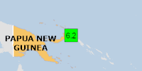
Time2025-04-12 03:47:10 UTC2025-04-12 03:47:10 UTC at epicenterLocation4.714°S 153.235°EDepth72.50 km (45.05 mi)
Click this link to continue reading the article on the source website.
RSS feed source: USGS Earthquake Hazards Program
On 4/12/2025 3:47:10 AM, an earthquake occurred in Papua New Guinea potentially affecting 20 thousand in 100km. The earthquake had Magnitude 6.2M, Depth:72.502km.
Click this link to continue reading the article on the source website.