RSS feed source: USGS Earthquake Hazards Program
Time2025-04-29 04:01:25 UTC2025-04-29 04:01:25 UTC at epicenterLocation6.249°S 149.971°EDepth60.28 km (37.46 mi)
Click this link to continue reading the article on the source website.
RSS feed source: USGS Earthquake Hazards Program
Time2025-04-29 04:01:25 UTC2025-04-29 04:01:25 UTC at epicenterLocation6.249°S 149.971°EDepth60.28 km (37.46 mi)
Click this link to continue reading the article on the source website.
RSS feed source: USGS Earthquake Hazards Program
Tue, 29 Apr 2025, 04:16 | BY: EARTHQUAKEMONITOR
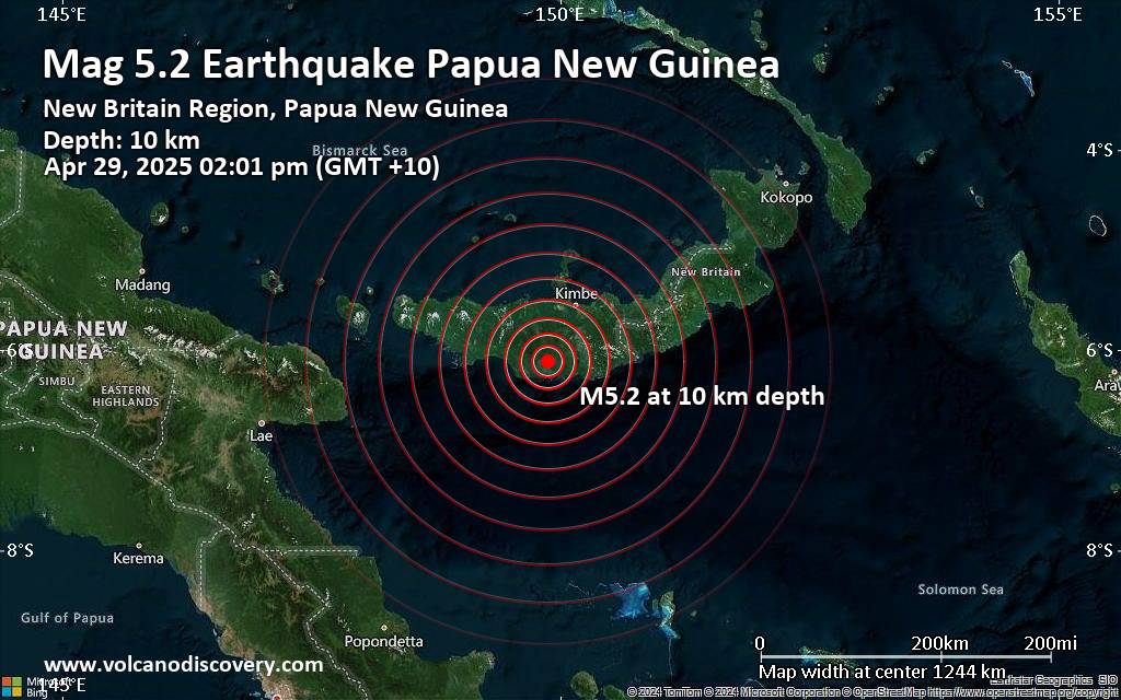
The German Research Centre for Geosciences (GFZ) reported a magnitude 5.2 quake in Papua New Guinea near Kimbe, Talasea District, West New Britain Province, only 14 minutes ago. The earthquake hit early afternoon on Tuesday, April 29th, 2025, at 2:01 pm local time at a shallow depth of 10. km. The exact magnitude, epicenter, and depth of the quake might be revised within the next few hours or minutes as seismologists review data and refine their calculations, or as other agencies issue their report.
Our monitoring service identified a second report from France’s Réseau National de Surveillance Sismique (RéNaSS) which listed the quake at magnitude 5.1. Other agencies reporting the same quake include Indonesia’s Meteorology, Climatology, and Geophysical Agency at magnitude 5.2, the European-Mediterranean Seismological Centre (EMSC) at magnitude 5.2, and the citizen-seismograph network of RaspberryShake at magnitude 5.1.
Based on the preliminary seismic data, the quake was probably felt by many people in the area of the epicenter. It should not have caused significant damage, other than objects falling from shelves, broken windows, etc.
In Kandrian (pop. 1000) located 37 km from the epicenter, the quake should have been felt as light shaking.
Weak shaking might have been felt in Kimbe (pop. 18,800) located 69 km from the epicenter.
VolcanoDiscovery will automatically update magnitude and depth if
Click this link to continue reading the article on the source website.
RSS feed source: USGS Earthquake Hazards Program
Date and TimeMag
DepthDistanceLocationDetailsMap Apr 14, 02:05 pm (Port Moresby)
4.6
64 km28 km (18 mi) to the E 61 km south of Kimbe, West New Britain Province, Papua New Guinea InfoApr 14, 05:52 am (GMT +10)
4.6
10 km109 km (68 mi) to the S Solomon Sea, 174 km south of Kimbe, West New Britain Province, Papua New Guinea InfoApr 12, 04:25 am (Port Moresby)
4.4
10 km58 km (36 mi) to the E 85 km SSE of Kimbe, Papua New Guinea InfoApr 10, 08:54 pm (Port Moresby)
4.7
23 km97 km (60 mi) to the E Solomon Sea, 96 km southeast of Kimbe, Papua New Guinea InfoApr 10, 12:15 am (Port Moresby)
4.3
10 km89 km (55 mi) to the E 93 km SE of Kimbe, Papua New Guinea InfoMar 28, 05:42 am (Port Moresby)
5.2
14 km33 km (20 mi) to the S Solomon Sea, 99 km south of Kimbe, West New Britain Province, Papua New Guinea 2 reportsInfoJan 1, 06:09 am (GMT +10)
5.1
10 km100 km (62 mi) to the SE 124 km ESE of Kandrian, Papua New Guinea InfoSep 1, 2024 05:38 pm (Port Moresby)
5.2
97 km44 km (27 mi) to the NW 75 km southwest of Kimbe, West New Britain Province, Papua New Guinea InfoMay 15, 2024 03:15 am (Port Moresby)
5.6
121 km61 km (38 mi) to the NE 10.9 km south of Kimbe, West New Britain Province, Papua New Guinea 1 reportInfoApr 7, 2024 05:25 pm (GMT +10)
5.1
47 km73 km (45 mi) to the SW Solomon Sea, 36 km southwest of Kandrian, Papua New Guinea 1 reportInfoApr 19, 2023 07:06 pm
Click this link to continue reading the article on the source website.
RSS feed source: USGS Earthquake Hazards Program
<!–div style="font-size:14px;text-align:center;border:3px solid blue;border-radius:5px;padding:3px;margin:5px;background:#eee"><a href="https://www.volcanoesandearthquakes.com/app/volcano-report.php?volcanoId=44" style="text-decoration:none" target="_blank" rel="noopener noreferrer nofollow" title="Share a volcano (activity) report, submit a photo or other interesting news!” onclick=”window.open(this.href,’Volcano Report’,’status=0,toolbar=0,location=0,directories=0,menubar=0,resizable=1,scrollbars=1,height=500,width=450′);return false”>Send Volcano Report</div–> Stratovolcano 3676 m (12,060 ft)
East Java, Indonesia, -8.11°S / 112.92°E
Current status: erupting (4 out of 5) Semeru volcano eruptions:
1818, 1829, 1830, 1832, 1836, 1838, 1842, 1844, 1845, 1848, 1849(?), 1851, 1856, 1857, 1865, 1866(?), 1887, 1887, 1888, 1889-91, 1892, 1893, 1893-94, 1895, 1896, 1897, 1899, 1899, 1900, 1901, 1903, 1904, 1905, 1907, 1908, 1909-10, 1910-11, 1911, 1912, 1913, 1941-42, 1945, 1946, 1946-47, 1950-64, 1967-ongoing
Typical eruption style
Explosive. Near constant strombolian activity, occasionally stronger explosions, lava flows and pyroclastic flows.
Click this link to continue reading the article on the source website.