RSS feed source: Global Disaster Alert and Coordination Systems (GDACS).

Thu, 10 Apr 2025, 08:01 | BY: EARTHQUAKEMONITOR

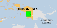
Indonesia’s Meteorology, Climatology, and Geophysical Agency reported a magnitude 5.7 quake in Indonesia near Agats, Asmat Regency, South Papua, only 7 minutes ago. The earthquake hit in the afternoon on Thursday, April 10th, 2025, at 4:53 pm local time at a moderately shallow depth of 57. km. The exact magnitude, epicenter, and depth of the quake might be revised within the next few hours or minutes as seismologists review data and refine their calculations, or as other agencies issue their report.
Based on the preliminary seismic data, the quake should not have caused any significant damage, but was probably felt by many people as light vibration in the area of the epicenter.
Weak shaking might have been felt in Agats (pop. 23,900) located 83 km from the epicenter.
VolcanoDiscovery will automatically update magnitude and depth if these change and follow up if other significant news about the quake become available. If you’re in the area, please send us your experience through our reporting mechanism, either online or via our mobile app. This will help us provide more first-hand updates to anyone around the globe who wants to know more about this quake.

If you felt it, report it through our site or app right now!

Download and Upgrade the Volcanoes & Earthquakes app to get one of the

Click this link to continue reading the article on the source website.

RSS feed source: Global Disaster Alert and Coordination Systems (GDACS).

Support us – Help us upgrade our services! We truly love working to bring you the latest volcano and earthquake data from around the world. Maintaining our website and our free apps does require, however, considerable time and resources.
We need financing to increase hard- and software capacity as well as support our editor team. We’re aiming to achieve uninterrupted service wherever an earthquake or volcano eruption unfolds, and your donations can make it happen! Every donation will be highly appreciated. If you find the information useful and would like to support our team in integrating further features, write great content, and in upgrading our soft- and hardware, please make a donation (PayPal).

Planned features:

Improved multilanguage supportTsunami alertsFaster responsivenessThanks to your past donations, these features have been added recently:Design upgradeDetailed quake statsAdditional seismic data sourcesDownload and Upgrade the Volcanoes & Earthquakes app to get one of

Click this link to continue reading the article on the source website.

RSS feed source: Global Disaster Alert and Coordination Systems (GDACS).

Background:

Volcán Popocatépetl, whose name is the Aztec word for smoking mountain, towers to 5426 m 70 km SE of Mexico City to form North America’s 2nd-highest volcano.  The glacier-clad stratovolcano contains a steep-walled, 250-450 m deep crater.  The generally symmetrical volcano is modified by the sharp-peaked Ventorrillo on the NW, a remnant of an earlier volcano. 
At least three previous major cones were destroyed by gravitational failure during the Pleistocene, producing massive debris-avalanche deposits covering broad areas south of the volcano.  The modern volcano was constructed to the south of the late-Pleistocene to Holocene El Fraile cone.  Three major plinian eruptions, the most recent of which took place about 800 AD, have occurred from Popocatépetl since the mid Holocene, accompanied by pyroclastic flows and voluminous lahars that swept basins below the volcano.  Frequent historical eruptions, first recorded in Aztec codices, have occurred since precolumbian

Click this link to continue reading the article on the source website.