RSS feed source: Volcano Discovery.com--Global earthquake monitor

Date and TimeMag
DepthDistanceLocationDetailsMap May 7, 05:09 pm (GMT +0)

4.5

10 km57 km (36 mi) to the NE 389 km northwest of Longyearbyen, Svalbard, Svalbard and Jan MayenI FELT IT InfoApr 1, 12:09 am (GMT +0)

4.6

10 km31 km (20 mi) to the E Greenland Sea InfoJan 23, 12:44 am (GMT +0)

4.0

10 km72 km (45 mi) to the SE 319 km northwest of Longyearbyen, Svalbard, Svalbard and Jan Mayen InfoNov 21, 2024 01:42 am (GMT +0)

4.5

10 km59 km (37 mi) to the E 329 km northwest of Longyearbyen, Svalbard, Svalbard and Jan Mayen InfoNov 20, 2024 02:43 pm (GMT +0)

5.7

2.4 km42 km (26 mi) to the E 347 km northwest of Longyearbyen, Svalbard, Svalbard and Jan Mayen InfoAug 31, 2024 02:03 pm (GMT +0)

4.3

10 km20 km (12 mi) to the NW Greenland Sea InfoJul 23, 2021 04:05 am (GMT +0)

5.3

10 km66 km (41 mi) to the E 331 km northwest of Longyearbyen, Svalbard, Svalbard and Jan Mayen InfoMar 23, 2021 02:08 pm (GMT +0)

5.2

10 km69 km (43 mi) to the SE 319 km northwest of Longyearbyen, Svalbard, Svalbard and Jan Mayen InfoJan 7, 2020 04:31 am (Universal Time)

5.0

10 km3.8 km (2.4 mi) to the NEnear Magnitude 5.0, Near of Severomorsk 1 reportInfoSep 2, 2019 01:02 pm (Universal Time)

5.1

10 km16 km (10 mi) to the Wnear Magnitude 5.2, Near of Severomorsk 1 reportInfoFeb 8, 2018 02:29 am (GMT +0)

5.7

10 km70 km (44 mi) to the E 319 km northwest of Longyearbyen, Svalbard, Svalbard and Jan Mayen InfoJun 9, 2017 08:49 pm (GMT +0)

5.2

10 km25 km (15 mi) to the E Greenland

Click this link to continue reading the article on the source website.

RSS feed source: Volcano Discovery.com--Global earthquake monitor

Support us – Help us upgrade our services! We truly love working to bring you the latest volcano and earthquake data from around the world. Maintaining our website and our free apps does require, however, considerable time and resources.
We need financing to increase hard- and software capacity as well as support our editor team. We’re aiming to achieve uninterrupted service wherever an earthquake or volcano eruption unfolds, and your donations can make it happen! Every donation will be highly appreciated. If you find the information useful and would like to support our team in integrating further features, write great content, and in upgrading our soft- and hardware, please make a donation (PayPal).

Planned features:

Improved multilanguage supportTsunami alertsFaster responsivenessThanks to your past donations, these features have been added recently:Design upgradeDetailed quake statsAdditional seismic data sourcesDownload and Upgrade the Volcanoes & Earthquakes app to get one of

Click this link to continue reading the article on the source website.

RSS feed source: Volcano Discovery.com--Global earthquake monitor

FRANKFORT, Ky. — Kentucky residents who were affected by the April 2 severe storms, straight-line winds, tornadoes, landslides and mudslides may be eligible for disaster assistance even if you have insurance

Under federal law, FEMA cannot duplicate insurance settlements or other benefits, but there are cases where insured survivors might still be eligible for FEMA help. For example:

Your settlement was delayed longer than 30 days after you filed a claim.The settlement does not fully cover all your losses and needs.You exhausted the additional living expenses provided in your policy.You cannot locate suitable rental resources in your community.

Residents of Anderson, Butler, Carroll, Christian, Clark, Franklin, Hardin, Hopkins, Jessamine, McCracken, Mercer, Owen and Woodford counties may apply. 

How To Apply for FEMA Assistance

The first step to receive FEMA assistance is to apply. Survivors of the April storms who live in the designated counties have until June 25 to apply for assistance. 

You can apply in several ways:

Online at DisasterAssistance.gov.Visit any Disaster Recovery Center. To find a center close to you, visit fema.gov/DRC, or text DRC along with your Zip Code to 43362 (Example: “DRC 29169”).Use the FEMA mobile app.Call the FEMA Helpline at 800-621-3362. It is open 7 a.m. to 10 p.m. Eastern Time. Help is available in many languages. If you use a relay service, such as Video Relay Service (VRS), captioned telephone or other service, give FEMA your number for that

Click this link to continue reading the article on the source website.
RSS feed source: Volcano Discovery.com--Global earthquake monitor

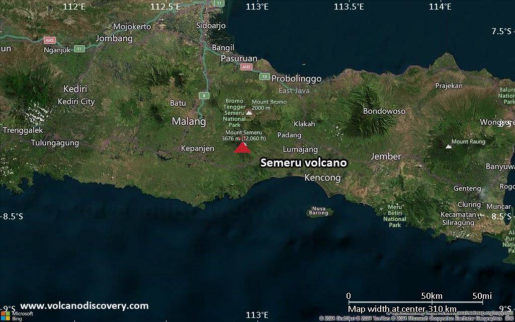
<!–div style="font-size:14px;text-align:center;border:3px solid blue;border-radius:5px;padding:3px;margin:5px;background:#eee"><a href="https://www.volcanoesandearthquakes.com/app/volcano-report.php?volcanoId=44" style="text-decoration:none" target="_blank" rel="noopener noreferrer nofollow" title="Share a volcano (activity) report, submit a photo or other interesting news!” onclick=”window.open(this.href,’Volcano Report’,’status=0,toolbar=0,location=0,directories=0,menubar=0,resizable=1,scrollbars=1,height=500,width=450′);return false”>Send Volcano Report</div–> Stratovolcano 3676 m (12,060 ft)
East Java, Indonesia, -8.11°S / 112.92°E
Current status: erupting (4 out of 5) Semeru volcano eruptions:
1818, 1829, 1830, 1832, 1836, 1838, 1842, 1844, 1845, 1848, 1849(?), 1851, 1856, 1857, 1865, 1866(?), 1887, 1887, 1888, 1889-91, 1892, 1893, 1893-94, 1895, 1896, 1897, 1899, 1899, 1900, 1901, 1903, 1904, 1905, 1907, 1908, 1909-10, 1910-11, 1911, 1912, 1913, 1941-42, 1945, 1946, 1946-47, 1950-64, 1967-ongoing
Typical eruption style
Explosive. Near constant strombolian activity, occasionally stronger explosions, lava flows and pyroclastic flows.

Click this link to continue reading the article on the source website.