RSS feed source: USGS Earthquake Hazards Program
Time2025-11-15 07:38:39 UTC2025-11-15 07:38:39 UTC at epicenterLocation11.267°N 123.915°EDepth10.00 km (6.21 mi)
Click this link to continue reading the article on the source website.
RSS feed source: USGS Earthquake Hazards Program
Time2025-11-15 07:38:39 UTC2025-11-15 07:38:39 UTC at epicenterLocation11.267°N 123.915°EDepth10.00 km (6.21 mi)
Click this link to continue reading the article on the source website.
RSS feed source: USGS Earthquake Hazards Program
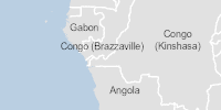
On 14/11/2025, a flood started in Democratic Republic of Congo, lasting until 14/11/2025 (last update). The flood caused 10 deaths and 63300 displaced .
Click this link to continue reading the article on the source website.
RSS feed source: USGS Earthquake Hazards Program
Support Us – Help Us Enhance Our Services! We’re passionate about delivering the latest volcano and earthquake data from around the globe — just for you. However, maintaining our website and free apps requires significant time, effort, and resources.
Your support helps us expand our hardware and software capabilities and empowers our dedicated editorial team. Our mission is to provide uninterrupted, real-time updates whenever an earthquake strikes or a volcano erupts — and your donations make this possible. Every contribution, big or small, is deeply appreciated. If you find our information valuable and want to help us add new features, create compelling content, and improve our technology, please consider making a donation: Donate with PayPal: Planned Features: Improved multilingual support Tsunami alerts Faster responsiveness Thanks to your past donations, we have recently added: Design upgrades Detailed earthquake
Click this link to continue reading the article on the source website.
RSS feed source: USGS Earthquake Hazards Program
Time2025-11-15 07:10:01 UTC2025-11-15 07:10:01 UTC at epicenterLocation23.661°S 66.512°WDepth208.45 km (129.53 mi)
Click this link to continue reading the article on the source website.