RSS feed source: USGS Earthquake Hazards Program
Time2025-10-23 09:02:07 UTC2025-10-23 09:02:07 UTC at epicenterLocation51.290°N 159.773°EDepth10.00 km (6.21 mi)
Click this link to continue reading the article on the source website.
RSS feed source: USGS Earthquake Hazards Program
Time2025-10-23 09:02:07 UTC2025-10-23 09:02:07 UTC at epicenterLocation51.290°N 159.773°EDepth10.00 km (6.21 mi)
Click this link to continue reading the article on the source website.
RSS feed source: USGS Earthquake Hazards Program
Thu, 23 Oct 2025, 08:43 | BY: EARTHQUAKEMONITOR
An earthquake of magnitude 2.8 occurred in the morning on Thursday, October 23rd, 2025, at 10:36 am local time near Montauban, Tarn-et-Garonne, Occitanie, France, as reported by France’s Réseau National de Surveillance Sismique (RéNaSS).
According to preliminary data, the quake was located at a very shallow depth of 5. km. Shallow earthquakes are felt more strongly than deeper ones as they are closer to the surface. The exact magnitude, epicenter, and depth of the quake might be revised within the next few hours or minutes as seismologists review data and refine their calculations, or as other agencies issue their report.
A second report was later issued by the European-Mediterranean Seismological Centre (EMSC), which listed it as a magnitude 2.9 earthquake.
Based on the preliminary seismic data, the quake should not have caused any significant damage, but was probably felt by many people as light vibration in the area of the epicenter.
Weak shaking might have been felt in Lafrancaise (pop. 2,800) located 3 km from the epicenter.
Other towns or cities near the epicenter where the quake might have been felt as very weak shaking include Cazes-Mondenard (pop. 1,300) located 8 km from the epicenter, Moissac (pop. 13,700) 14 km away, Castelsarrasin (pop. 13,300) 17 km away, and Montauban (pop. 52,400) 18 km away. In Caussade (pop. 6,300,
Click this link to continue reading the article on the source website.
RSS feed source: USGS Earthquake Hazards Program
Thu, 23 Oct 2025, 06:50 | BY: EARTHQUAKEMONITOR
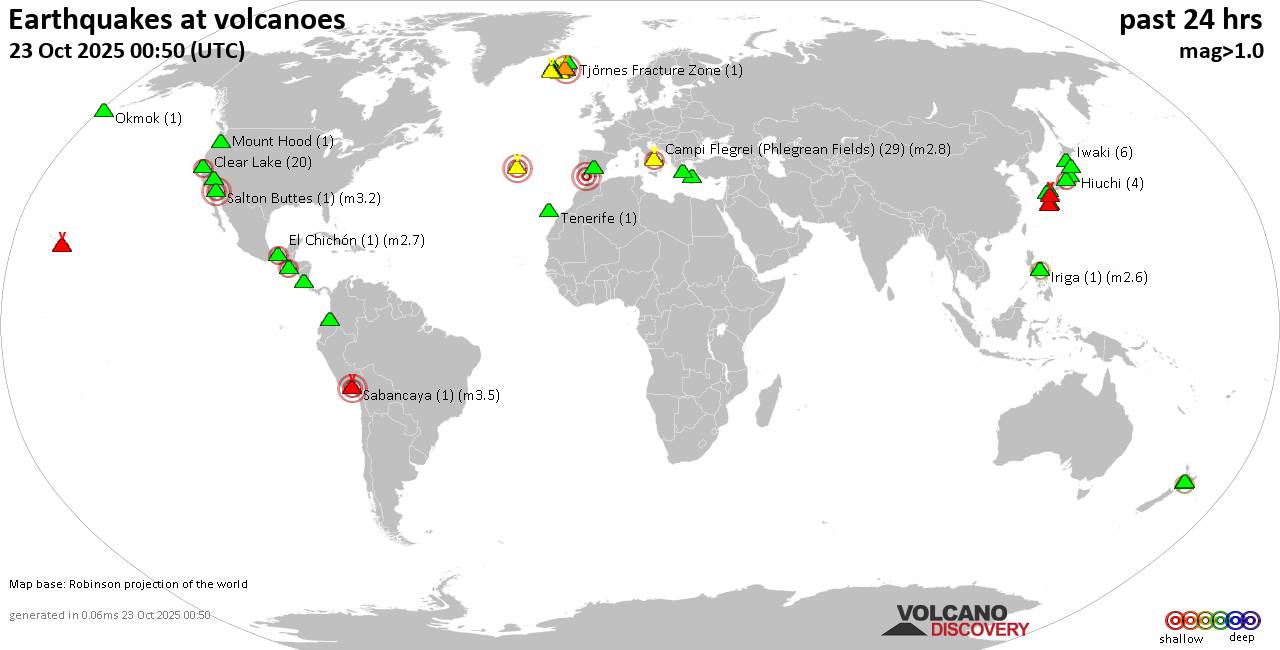
World map showing volcanoes with shallow (less than 50 km) earthquakes within 20 km radius during the past 24 hours on 23 Oct 2025 Number in brackets indicate nr of quakes.
Quakes detected near: Bardarbunga (3 quakes between mag 1.5-3.1), Brennisteinsfjöll (5 quakes between mag 0.4-1.7), Calatrava (1 quake mag 3.0), Campi Flegrei (Phlegrean Fields) (20 quakes between mag 0.1-1.3), Clear Lake (18 quakes between mag 0.2-2.3), Coso (3 quakes between mag 0.2-1.3)
Cuernos de Negros (1 quake mag 3.0), El Chichón (13 quakes between mag 1.8-3.0), Eldey (1 quake mag 1.0), Galeras (2 quakes between mag 1.6-3.1), Grímsvötn (1 quake mag 1.2), Hiuchi (6 quakes between mag 0.1-1.2), Hrómundartindur (1 quake mag 1.0), Iriga (1 quake mag 2.6), Isarog (1 quake mag 2.3), Iwaki (6 quakes between mag 0.3-1.2), Katla (6 quakes between mag 0.1-1.9), Kenger (2 quakes between mag 0.9-1.2), Kilauea (2 quakes between mag 1.2-1.6), Kirishima (2 quakes between mag 1.0-1.0), Kolumbo (1 quake mag 1.7), Krísuvík (71 quakes between mag 0.1-3.6), Kuchinoshima (1 quake mag 1.6), Kuju (1 quake mag 1.0), Kurikoma (8 quakes between mag 0.1-1.5), Mount Hood (1 quake mag 1.0), Okmok (1 quake mag 1.3), Sabancaya (1 quake mag 3.5), Salton Buttes (1 quake mag 3.0), Sousaki (1 quake mag 1.2), Suwanose-jima (1 quake mag 2.2), Tenorio (1 quake
Click this link to continue reading the article on the source website.
RSS feed source: USGS Earthquake Hazards Program
131 km (81 mi)
SW of epicenter
(pop: 894)
II: Very weak
Alto Lucero de Gutierrez Barrios, Estado de Veracruz-Llave 134 km (83 mi)
SW of epicenter
(pop: 3,140)
II: Very weak
Alto Lucero de Gutierrez Barrios, Estado de Veracruz-Llave 135 km (84 mi)
SW of epicenter
(pop: 7,650)
II: Very weak
Estado de Veracruz-Llave 139 km (86 mi)
W of epicenter
(pop: 3,040)
II: Very weak
Estado de Veracruz-Llave 147 km (91 mi)
SW of epicenter
(pop: 2,090)
II: Very weak
Actopan, Estado de Veracruz-Llave 149 km (92 mi)
W of epicenter
(pop: 6,520)
II: Very weak
Estado de Veracruz-Llave 149 km (92 mi)
W of epicenter
(pop: 1,260)
II: Very weak
Tecolutla, Estado de Veracruz-Llave 150 km (93 mi)
SW of epicenter
(pop: 2,770)
II: Very weak
Estado de Veracruz-Llave 154 km (96 mi)
SW of epicenter
(pop: 1,590)
II: Very weak
Actopan, Estado de Veracruz-Llave 156 km (97 mi)
SW of epicenter
(pop: 2,180)
II: Very weak
Misantla, Estado de Veracruz-Llave 157 km (97 mi)
W of epicenter
(pop: 4,590)
II: Very weak
Estado de Veracruz-Llave 157 km (98 mi)
SW of epicenter
(pop: 1,040)
II: Very
Click this link to continue reading the article on the source website.