RSS feed source: Volcano Discovery.com--Global earthquake monitor

Date and TimeMag
DepthDistanceLocationDetailsMap Nov 16, 02:35 pm (Manila)

4.5

86 km79 km (49 mi) to the E Philippine Sea, 54 km south of Mati, PhilippinesI FELT IT1 reportInfoNov 7, 10:27 am (GMT +8)

4.2

135 km101 km (63 mi) to the SE Mindanao, Philippines InfoNov 4, 10:30 pm (Manila)

4.4

27 km76 km (47 mi) to the S Province of Sarangani, 42 km southeast of General Santos, Philippines InfoOct 16, 05:32 am (Manila)

4.4

158 km47 km (29 mi) to the SE Philippine Sea, 20 km southeast of Malita, Davao Occidental, Davao, Philippines InfoOct 10, 08:48 pm (Manila)

4.0

112 km64 km (40 mi) to the S Province of Sarangani, 30 km southeast of General Santos, Philippines InfoOct 10, 09:43 am (Manila)

7.4

58 km166 km (103 mi) to the NE Philippine Sea, 24 km east of Manay, Philippines 451 reportsInfoSep 29, 11:00 am (GMT +8)

4.9

117 km93 km (58 mi) to the SE Philippine Sea, 67 km southeast of Malita, Davao Occidental, Davao, Philippines 1 reportInfoJul 23, 06:21 pm (Manila)

4.9

138 km76 km (47 mi) to the E Philippine Sea, 58 km south of Mati, Philippines 1 reportInfoJun 23, 07:34 am (GMT +8)

4.7

86 km121 km (75 mi) to the E Philippine Sea, 86 km south of Mati, Philippines InfoJun 18, 03:49 am (Manila)

4.7

52 km88 km (55 mi) to the S Philippine Sea, 45 km northeast of Sarangani Island, Philippines InfoMay 26, 06:48 pm (GMT +8)

4.9

98 km125 km (78 mi) to the SE Philippine Sea, 83 km northeast of Sarangani Island, Philippines InfoJul 11, 2024 10:13 am (GMT +8)

7.1

640 km257 km (160 mi) to the W 98 km WSW

Click this link to continue reading the article on the source website.

RSS feed source: Volcano Discovery.com--Global earthquake monitor

Friday, Nov 21, 2025 23:50 | 4 hours ago | By: EarthquakeMonitor

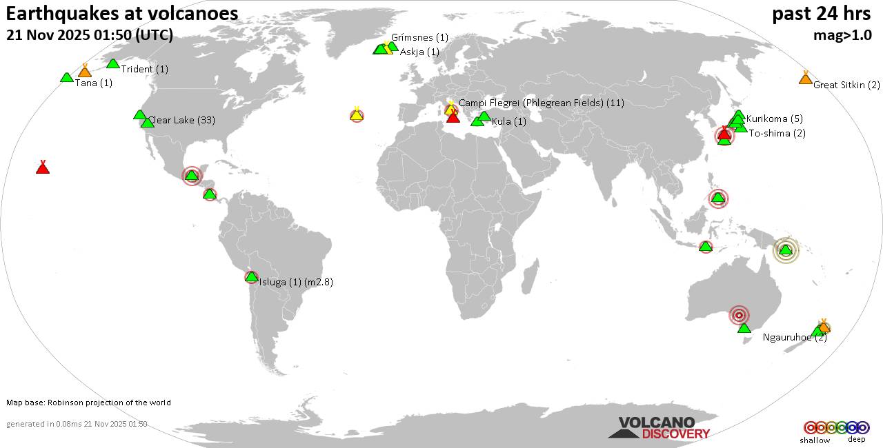
World map showing volcanoes with shallow (less than 50 km) earthquakes within 20 km radius during the past 24 hours on 21 Nov 2025 Number in brackets indicate nr of quakes.

Quakes detected near: Akuseki-jima (2 quakes between mag 1.7-2.0), Aniakchak (2 quakes between mag 1.0-1.3), Bardarbunga (2 quakes between mag 1.2-3.0), Biliran (1 quake mag 2.6), Binuluan (1 quake mag 1.6), Brennisteinsfjöll (2 quakes between mag 0.8-1.1)
Campi Flegrei (Phlegrean Fields) (9 quakes between mag 0.1-1.3), Clear Lake (36 quakes between mag 0.2-1.9), Coso (2 quakes between mag 1.4-1.9), Don Joao de Castro Bank (1 quake mag 2.5), El Chichón (17 quakes between mag 1.7-2.6), Eldey (5 quakes between mag 1.1-2.1), Fagradalsfjall (1 quake mag 1.2), Galeras (1 quake mag 3.0), Katla (4 quakes between mag 0.5-1.5), Kilauea (2 quakes between mag 1.2-2.2), Komaga-take (2 quakes between mag 0.6-1.6), Krafla (2 quakes between mag 0.3-1.3), Krísuvík (11 quakes between mag 0.2-2.2), Ljósufjöll (4 quakes between mag 0.7-1.0), Los Humeros (1 quake mag 3.0), Mammoth Mountain (1 quake mag 1.1), Mauna Kea (1 quake mag 1.7), Maunaloa (1 quake mag 1.8), Mayotte Island (1 quake mag 1.4), Mount Rainier (7 quakes between mag 0.3-2.2), Nantai (1 quake mag 1.1), Nejapa-Miraflores (1 quake mag 3.0), Nipesotsu-Maruyama (6 quakes between mag 0.9-2.7), Ontake-san

Click this link to continue reading the article on the source website.
RSS feed source: Volcano Discovery.com--Global earthquake monitor

<!–div style="font-size:14px;text-align:center;border:3px solid blue;border-radius:5px;padding:3px;margin:5px;background:#eee"><a href="https://www.volcanoesandearthquakes.com/app/volcano-report.php?volcanoId=26" style="text-decoration:none" target="_blank" rel="noopener noreferrer nofollow" title="Share a volcano (activity) report, submit a photo or other interesting news!” onclick=”window.open(this.href,’Volcano Report’,’status=0,toolbar=0,location=0,directories=0,menubar=0,resizable=1,scrollbars=1,height=500,width=450′);return false”>Send Volcano Report</div–> Stratovolcano 3,763 m / 12,346 ft
Guatemala, 14.47°N / -90.88°W
Current status: erupting (4 out of 5) Fuego volcano eruptions:
1581, 1585, 1586, 1587, 1614, 1617, 1620, 1623, 1629, 1679(?), 1685, 1686, 1689(?), 1699, 1702, 1705, 1706, 1709(?), 1710,1717,1730, 1732, 1737, 1751(?), 1765(?), 1773(?), 1799, 1826, 1829, 1850(?), 1852(?), 1855, 1856, 1857, 1860, 1861(?), 1867(?), 1880, 1896, 1932, 1944, 1949, 1953, 1955, 1957, 1962, 1963, 1966, 1967, 1971, 1973, 1974, 1975, 1977, 1987, 1999, 2002 – ongoing
Typical eruption style
Dominantly explosive, construction of lava domes and extrusion of viscous lava flows. In near constant activity, at least during the past centuries.

Click this link to continue reading the article on the source website.

RSS feed source: Volcano Discovery.com--Global earthquake monitor

<!–div style="font-size:14px;text-align:center;border:3px solid blue;border-radius:5px;padding:3px;margin:5px;background:#eee"><a href="https://www.volcanoesandearthquakes.com/app/volcano-report.php?volcanoId=44" style="text-decoration:none" target="_blank" rel="noopener noreferrer nofollow" title="Share a volcano (activity) report, submit a photo or other interesting news!” onclick=”window.open(this.href,’Volcano Report’,’status=0,toolbar=0,location=0,directories=0,menubar=0,resizable=1,scrollbars=1,height=500,width=450′);return false”>Send Volcano Report</div–> Stratovolcano 3676 m (12,060 ft)
East Java, Indonesia, -8.11°S / 112.92°E
Current status: erupting (4 out of 5) Semeru volcano eruptions:
1818, 1829, 1830, 1832, 1836, 1838, 1842, 1844, 1845, 1848, 1849(?), 1851, 1856, 1857, 1865, 1866(?), 1887, 1887, 1888, 1889-91, 1892, 1893, 1893-94, 1895, 1896, 1897, 1899, 1899, 1900, 1901, 1903, 1904, 1905, 1907, 1908, 1909-10, 1910-11, 1911, 1912, 1913, 1941-42, 1945, 1946, 1946-47, 1950-64, 1967-ongoing
Typical eruption style
Explosive. Near constant strombolian activity, occasionally stronger explosions, lava flows and pyroclastic flows.

Click this link to continue reading the article on the source website.