RSS feed source: Volcano Discovery.com--Global earthquake monitor

Date and TimeMag
DepthDistanceLocationDetailsMap Nov 23, 04:07 am (GMT +9)

4.1

174 km85 km (53 mi) to the SW Maluku Sea, 7 km west of Pulau Dagasuli Island, North Maluku, IndonesiaI FELT IT InfoNov 10, 05:33 pm (GMT +9)

4.2

117 km86 km (54 mi) to the NW Maluku Sea, 87 km north of Pulau Rau Island, North Maluku, Indonesia InfoOct 30, 01:13 am (GMT +9)

4.4

10 km49 km (31 mi) to the NW Maluku Sea, 55 km north of Pulau Rau Island, North Maluku, Indonesia InfoOct 29, 07:18 pm (Jayapura)

4.3

202 km32 km (20 mi) to the N Maluku Sea, 50 km north of Morotai Island, Indonesia InfoSep 2, 05:21 pm (Jayapura)

4.1

206 km13 km (8.3 mi) to the E Kabupaten Pulau Morotai, 101 km northeast of Tobelo, Indonesia InfoAug 26, 10:44 am (Jayapura)

4.6

170 km15 km (9.6 mi) to the NW Maluku Sea, 33 km northeast of Pulau Rau Island, North Maluku, Indonesia InfoJul 12, 01:00 pm (Jayapura)

4.7

22 km83 km (52 mi) to the S 46 km east of Tobelo, Kabupaten Halmahera Utara, North Maluku, Indonesia InfoFeb 18, 03:45 pm (GMT +9)

4.6

10 km58 km (36 mi) to the NMaluku Sea, 183 km southeast of Pulau Kaburuang Island, Indonesia InfoFeb 4, 06:35 am (GMT +9)

5.9

103 km63 km (39 mi) to the N Maluku Sea, North Maluku, 178 km southeast of Pulau Kaburuang Island, Indonesia 2 reportsInfoJan 23, 12:32 am (GMT +9)

4.6

112 km96 km (60 mi) to the NW Maluku Sea, 143 km southeast of Pulau Kaburuang Island, Indonesia InfoNov 22, 2024 04:51 pm (GMT +9)

5.4

13 km35 km (22 mi) to the NW

Click this link to continue reading the article on the source website.

RSS feed source: Volcano Discovery.com--Global earthquake monitor

Date and TimeMag
DepthDistanceLocationDetailsMap Sep 2, 05:38 pm (GMT +5)

4.6

10 km20 km (13 mi) to the SE Indian Ocean, British Indian Ocean Territory InfoJun 1, 01:14 pm (GMT +5)

4.6

10 km31 km (19 mi) to the SE Indian Ocean, British Indian Ocean Territory InfoMar 6, 05:35 pm (GMT +5)

4.6

10 km48 km (30 mi) to the S Indian Ocean, British Indian Ocean Territory InfoSep 24, 2024 06:49 am (GMT +5)

4.4

10 km82 km (51 mi) to the SChagos Archipelago Region InfoApr 10, 2024 10:10 am (GMT +5)

4.5

10 km40 km (25 mi) to the NE Chagos Archipelago Region InfoAug 14, 2022 06:59 pm (GMT +5)

4.8

10 km36 km (22 mi) to the W Indian Ocean, British Indian Ocean Territory InfoJan 8, 2022 02:46 am (GMT +5)

5.1

10 km26 km (16 mi) to the SE Chagos Archipelago Region InfoDec 18, 2021 06:39 pm (GMT +5)

4.9

10 km29 km (18 mi) to the NE Indian Ocean, British Indian Ocean Territory InfoDec 18, 2021 12:15 am (GMT +5)

4.8

10 km31 km (19 mi) to the N Chagos Archipelago Region InfoMay 21, 2021 09:02 pm (GMT +5)

5.7

10 km93 km (58 mi) to the NW Indian Ocean, British Indian Ocean Territory InfoJul 10, 2020 11:29 am (GMT +5)

5.3

10 km80 km (50 mi) to the N Indian Ocean, British Indian Ocean Territory InfoSep 5, 2019 02:12 pm (GMT +5)

5.4

10 km98 km (61 mi) to the N Indian Ocean, British Indian Ocean Territory InfoMar 24, 2019 08:37 am (GMT +5)

5.1

10 km80 km (49 mi) to the NCarlsberg Ridge InfoJan 17, 2019 03:52 pm (GMT +5)

5.0

10 km91 km (57 mi) to the S Indian Ocean, British Indian Ocean Territory InfoMar 26,

Click this link to continue reading the article on the source website.
RSS feed source: Volcano Discovery.com--Global earthquake monitor

Monday, Nov 24, 2025 00:24 | 8 hours ago | By: EarthquakeMonitor

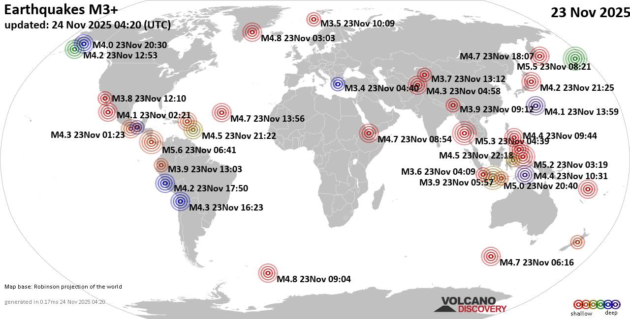
Worldwide earthquakes above magnitude 3 during the past 24 hours on 24 Nov 2025

Summary: 5 quakes 5.0+, 42 quakes 4.0+, 134 quakes 3.0+, 279 quakes 2.0+ (460 total)
Magnitude 5+: 5 earthquakes
Magnitude 4+: 42 earthquakes
Magnitude 3+: 134 earthquakes
Magnitude 2+: 279 earthquakes
No quakes of magnitude 6 or higherTotal seismic energy estimate: 5.2 x 10¹³ joules (14.6 gigawatt hours, equivalent to 12525 tons of TNT or 0.8 atomic bombs!) | equivalent to ONE quake of magnitude 5.9 learn more10 largest earthquakes in the world (23 Nov 2025)#1: Mag 5.6 North Pacific Ocean, 86 km southwest of San Isidro, Costa RicaSunday, Nov 23, 2025, at 12:41 am (GMT -6) – #2: Mag 5.5 Bering Sea, 37 mi southwest of Adak, Aleutians West Census Area, Alaska, United StatesSaturday, Nov 22, 2025, at 10:21 pm (GMT -10) – #3: Mag 5.3 Andaman Sea, 308 km east of Landfall Island, IndiaSunday, Nov 23, 2025, at 10:09 am (GMT +5:30) – #4: Mag 5.2 East Halmahera Regency, 131 km northeast of Sofifi, IndonesiaSunday, Nov 23, 2025, at 12:19 pm (GMT +9) – #5: Mag 5.0 Indian Ocean, 130 km south of Blitar, Kota Blitar, Jawa Timur, IndonesiaMonday, Nov 24, 2025, at 03:40 am (GMT +7) – #6: Mag 4.8 South Atlantic Ocean, 183 km east of Montagu

Click this link to continue reading the article on the source website.