RSS feed source: Volcano Discovery.com--Global earthquake monitor

Date and TimeMag
DepthDistanceLocationDetailsMap Oct 17, 06:55 am (GMT +3)

4.1

31 km24 km (15 mi) to the E Eastern Mediterranean, 60 km west of Kissamos, Chania, Crete, Greece 2 reportsInfoAug 20, 05:27 pm (GMT +2)

4.2

29 km72 km (45 mi) to the SE 29 km SW From Palaiochora InfoAug 18, 03:11 pm (Athens)

4.1

6.3 km64 km (39 mi) to the E Eastern Mediterranean, 53 km west of Chania, Chania, Crete, Greece 22 reportsInfoJul 23, 04:26 pm (Athens)

5.1

61 km82 km (51 mi) to the NE Eastern Mediterranean, Crete, 19 km east of Nisi Antikythira Island, Greece 323 reportsInfoJul 8, 11:48 pm (GMT +3)

4.0

10 km47 km (29 mi) to the NE Eastern Mediterranean, 28 km southwest of Nisi Antikythira Island, Greece InfoJul 21, 2024 07:01 am (GMT +3)

5.3

17 km70 km (43 mi) to the SE 57 Km SW from Palaiochora 22 reportsInfoMar 14, 2023 05:36 pm (GMT +1)

5.2

15 km61 km (38 mi) to the NW Eastern Mediterranean, 105 km southwest of Cythera Island, Greece 4 reportsInfoApr 27, 2022 03:51 am (GMT +2)

5.2

79 km59 km (37 mi) to the N Eastern Mediterranean, 71 km southwest of Elafonisos Island, Greece 6 reportsInfoDec 18, 2021 08:16 am (Athens)

5.4

58 km88 km (55 mi) to the NE Attica, 96 km northwest of Chania, Chania, Crete, Greece 40 reportsInfoNov 27, 2019 10:23 am (Athens)

5.9

54 km54 km (33 mi) to the NE Crete, Greece 954 reportsInfoOct 12, 2013 04:11 pm (Athens)

6.4

52 km50 km (31 mi) to the ECrete, Greece [Sea: Greece] 277 reportsInfoFeb 3, 2007 02:43 pm (GMT +1)

5.4

59 km55 km (34 mi) to the NW Eastern Mediterranean, 70 km southwest

Click this link to continue reading the article on the source website.
RSS feed source: Volcano Discovery.com--Global earthquake monitor

Date and TimeMag
DepthDistanceLocationDetailsMap Nov 3, 09:25 pm (GMT +9)

4.1

120 km53 km (33 mi) to the W Banda Sea InfoNov 2, 02:13 pm (GMT +9)

4.2

5 km86 km (53 mi) to the NE Tanimbar Islands Region, Indonesia InfoNov 1, 04:25 pm (Jayapura)

4.2

161 km78 km (48 mi) to the W Banda Sea InfoNov 1, 06:10 am (GMT +9)

4.3

197 km Banda Sea InfoOct 28, 11:40 pm (GMT +9)

6.4

168 km83 km (51 mi) to the NE Banda Sea, 83 km northeast of Pulau Dai Island, Maluku, Indonesia 195 reportsInfoOct 18, 10:13 pm (Jayapura)

4.4

146 km13 km (8.3 mi) to the E Banda Sea InfoOct 10, 07:02 pm (Jayapura)

5.4

169 km22 km (14 mi) to the NE Banda Sea, 33 km north of Pulau Dai Island, Maluku, Indonesia 1 reportInfoSep 24, 03:09 am (Jayapura)

4.4

193 km40 km (25 mi) to the NE Banda Sea, 54 km north of Pulau Dai Island, Maluku, Indonesia InfoSep 22, 03:47 pm (GMT +9)

4.5

176 km99 km (61 mi) to the NE Banda Sea, 107 km north of Pulau Dai Island, Maluku, Indonesia InfoJun 24, 2024 06:55 pm (GMT +9)

6.0

153 km63 km (39 mi) to the NE Di laut 170 km baratlaut Saumlaki 29 reportsInfoNov 8, 2023 01:53 pm (GMT +9)

7.1

6 km110 km (68 mi) to the N Banda Sea, 166 km north of Pulau Wetan Island, Maluku, Indonesia InfoOct 26, 2023 02:44 pm (Jayapura)

6.1

10 km18 km (11 mi) to the W Indonesia: Di Laut 176 Km Timur Laut Maluku Barat Daya 24 reportsInfoSep 22, 2023 11:59 pm (Jayapura)

6.6

214 km50 km (31 mi) to the NE Indonesia: Di Laut 184 Km Barat Laut Tanimbar

Click this link to continue reading the article on the source website.

RSS feed source: Volcano Discovery.com--Global earthquake monitor

Tuesday, Nov 11, 2025 00:50 | 50 mins ago | By: EarthquakeMonitor

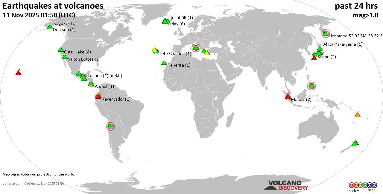
World map showing volcanoes with shallow (less than 50 km) earthquakes within 20 km radius during the past 24 hours on 11 Nov 2025 Number in brackets indicate nr of quakes.

Quakes detected near: Akagi (8 quakes between mag 0.2-3.0), Aoba (1 quake mag 1.7), Arenal (1 quake mag 2.1), Cerro Negro de Mayasquer (2 quakes between mag 0.4-2.3), Clear Lake (4 quakes between mag 0.7-1.8), Cuernos de Negros (1 quake mag 3.0)
Denison (1 quake mag 1.7), El Chichón (8 quakes between mag 1.8-2.8), Eldey (4 quakes between mag 0.2-1.9), Haku-san (1 quake mag 1.2), Hekla (2 quakes between mag 0.8-1.0), Kaguyak (1 quake mag 2.1), Kilauea (1 quake mag 1.7), Kirishima (7 quakes between mag 0.1-1.2), Kolumbo (8 quakes between mag 1.1-2.5), Krísuvík (5 quakes between mag 0.3-1.2), Ljósufjöll (1 quake mag 1.6), Marapi (2 quakes between mag 2.2-2.3), Maunaloa (3 quakes between mag 1.0-1.6), Midagahara (4 quakes between mag 0.3-1.6), Reporoa (1 quake mag 1.3), Reventador (1 quake mag 1.6), Ruapehu (3 quakes between mag 1.0-1.3), Salton Buttes (1 quake mag 1.1), Sanbe (2 quakes between mag 1.0-2.0), Santorini (3 quakes between mag 0.0-1.1), Serdán-Oriental (1 quake mag 3.1), Sete Cidades (1 quake mag 2.4), Socompa (1 quake mag 3.0), Sousaki (1 quake mag 1.4), Tacana (1 quake

Click this link to continue reading the article on the source website.