RSS feed source: Volcano Discovery.com--Global earthquake monitor

Fri, 7 Nov 2025, 00:20 | BY: EARTHQUAKEMONITOR

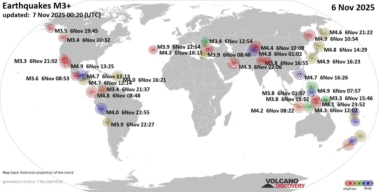
Worldwide earthquakes above magnitude 3 during the past 24 hours on 7 Nov 2025

Summary: 35 quakes 4.0+, 120 quakes 3.0+, 307 quakes 2.0+ (462 total)
This report is being updated every hour.
Magnitude 4+: 35 earthquakes
Magnitude 3+: 120 earthquakes
Magnitude 2+: 307 earthquakes
No quakes of magnitude 5 or higherTotal seismic energy estimate: 2 x 10¹³ joules (5.58 gigawatt hours, equivalent to 4799 tons of TNT or 0.3 atomic bombs!) | equivalent to ONE quake of magnitude 5.7 learn more10 largest earthquakes in the world (past 24 hours)#1: Mag 4.9 Philippine Sea, 53 km east of Miyazaki, Miyazaki, JapanFriday, Nov 7, 2025, at 01:23 am (GMT +9) – #2: Mag 4.9 107 km west of Guaymas, Estado de Sonora, MexicoThursday, Nov 6, 2025, at 06:25 am (GMT -7) – #3: Mag 4.9 57 km southwest of Nogliki, Noglikskii, Sakhalin Oblast, RussiaThursday, Nov 6, 2025, at 09:54 pm (Sakhalin time) – #4: Mag 4.9 Tasman Sea, 27 km northwest of Wellington, Wellington, New ZealandThursday, Nov 6, 2025, at 09:09 pm (Auckland time) – #5: Mag 4.9 Philippine Sea, 19 km northeast of Manay, PhilippinesThursday, Nov 6, 2025, at 03:57 pm (Manila time) – #6: Mag 4.8 98 km west of Guaymas, Estado de Sonora, MexicoThursday, Nov 6, 2025, at 09:36 am (GMT -7) – #7: Mag 4.8 North Pacific Ocean,

Click this link to continue reading the article on the source website.

RSS feed source: Volcano Discovery.com--Global earthquake monitor

Date and TimeMag
DepthDistanceLocationDetailsMap Nov 2, 02:01 am (GMT -7)

3.9

12 km75 km (47 mi) to the SE 78 km southwest of Guaymas, Estado de Sonora, MexicoI FELT IT

Info

Oct 21, 07:10 pm (GMT -7)

4.2

12 km72 km (45 mi) to the SE 65 km southwest of Guaymas, Estado de Sonora, Mexico 3 reportsInfoSep 5, 03:49 am (GMT -7)

3.6

19 km31 km (19 mi) to the SE 84 km west of Guaymas, Estado de Sonora, Mexico

Info

Aug 13, 11:58 am (GMT -7)

3.0

10 km63 km (39 mi) to the SE 69 km southwest of Guaymas, Estado de Sonora, Mexico

Info

Aug 5, 11:20 pm (GMT -7)

4.2

10 km65 km (40 mi) to the SE 63 km southwest of Guaymas, Estado de Sonora, Mexico 3 reportsInfoJun 5, 2024 12:55 am (GMT -7)

4.7

10 km36 km (22 mi) to the SE 77 km west of Guaymas, Estado de Sonora, Mexico 14 reportsInfoMay 3, 2023 01:03 am (GMT -7)

4.5

10 km41 km (25 mi) to the SE 74 km west of Guaymas, Estado de Sonora, Mexico 17 reportsInfoAug 6, 2022 09:08 am (GMT -7)

4.7

10 km40 km (25 mi) to the SEGulf of California 34 reportsInfoDec 23, 2021 07:13 am (GMT -7)

4.6

16 km98 km (61 mi) to the SE 79 km southwest of Guaymas, Estado de Sonora, Mexico 5 reportsInfoJul 31, 2021 08:39 am (GMT -7)

5.5

5 km56 km (35 mi) to the SE 63 km southwest of Guaymas, Estado de Sonora, Mexico 53 reportsInfoOct 4, 2020 10:13 am (GMT -7)

4.5

10 km83 km (51 mi) to the E 41 km southwest of Heroica Guaymas, Sonora, Mexico InfoMay 22,

Click this link to continue reading the article on the source website.

RSS feed source: Volcano Discovery.com--Global earthquake monitor

Date and TimeMag
DepthDistanceLocationDetailsMap Nov 6, 05:16 pm (GMT +9)

4.0

114 km36 km (23 mi) to the NW Banda Sea, 149 km northwest of Pulau Molu Island, Maluku, IndonesiaI FELT IT InfoNov 5, 09:56 pm (GMT +9)

4.7

148 km50 km (31 mi) to the SW Banda Sea, 137 km northwest of Pulau Molu Island, Maluku, IndonesiaI FELT IT InfoNov 2, 01:30 pm (GMT +9)

4.2

77 km87 km (54 mi) to the E Banda Sea, 73 km north of Pulau Molu Island, Maluku, IndonesiaI FELT IT InfoOct 29, 09:26 pm (GMT +9)

4.9

104 km59 km (37 mi) to the E Tanimbar Islands Region, Indonesia InfoOct 27, 09:26 pm (GMT +9)

4.0

189 km68 km (42 mi) to the SW Banda Sea, 145 km northwest of Pulau Maru Island, Maluku, Indonesia InfoOct 23, 08:46 pm (GMT +9)

5.6

117 km41 km (25 mi) to the SE Tanimbar Islands Region, Indonesia 5 reportsInfoOct 21, 06:06 pm (GMT +9)

4.4

111 km61 km (38 mi) to the NE Banda Sea InfoJul 14, 02:49 pm (GMT +9)

6.7

98 km63 km (39 mi) to the SE Banda Sea, 56 km northwest of Pulau Molu Island, Maluku, Indonesia 153 reportsInfoNov 11, 2023 05:45 am (GMT +9)

6.1

10 km85 km (53 mi) to the W Banda Sea, 209 km north of Pulau Wetan Island, Maluku, Indonesia InfoNov 10, 2023 12:50 pm (GMT +9)

5.9

10 km67 km (41 mi) to the W 283 km W of Tual, Indonesia InfoNov 8, 2023 01:53 pm (GMT +9)

7.1

6 km148 km (92 mi) to the W Banda Sea, 166 km north of Pulau Wetan Island, Maluku, Indonesia InfoAug 29,

Click this link to continue reading the article on the source website.