RSS feed source: USGS Earthquake Hazards Program
Time2025-10-24 04:20:33 UTC2025-10-24 04:20:33 UTC at epicenterLocation7.597°N 127.355°EDepth10.00 km (6.21 mi)
Click this link to continue reading the article on the source website.
RSS feed source: USGS Earthquake Hazards Program
Time2025-10-24 04:20:33 UTC2025-10-24 04:20:33 UTC at epicenterLocation7.597°N 127.355°EDepth10.00 km (6.21 mi)
Click this link to continue reading the article on the source website.
RSS feed source: USGS Earthquake Hazards Program
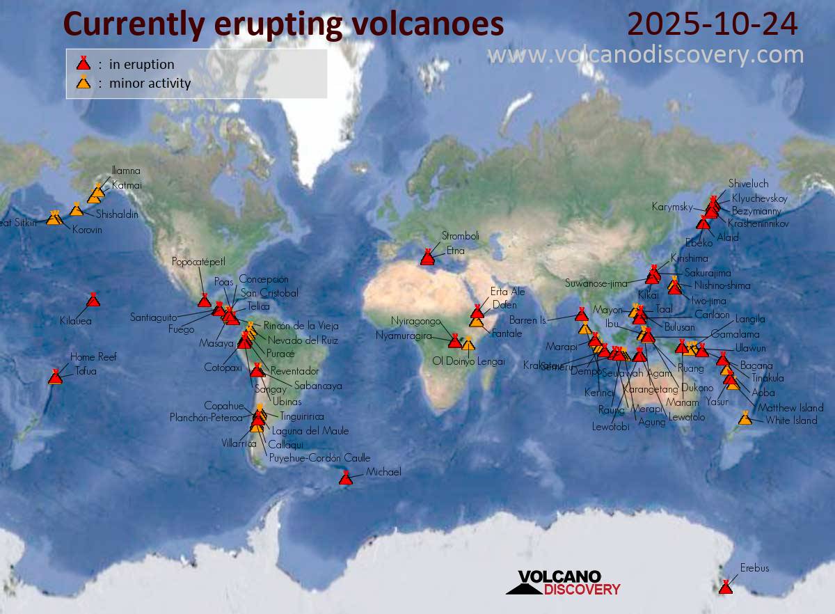
Fri, 24 Oct 2025, 21:00 1761339608 | BY: SEVERAL CONTRIBUTORS
Map of today’s active volcanoes
Krasheninnikov (Kamchatka, Russia): Explosive activity continues. Volcanic Ash Advisory Center (VAAC) Tokyo warned about a volcanic ash plume that rose up to estimated 9000 ft (2700 m) altitude or flight level 090 and is moving at 15 kts in SE direction.
The full report is as follows: VA EMISSIONS CONTINUING OBS VA DTG:24/1120Z to 9000 ft (2700 m)
Canlaon (Central Philippines): Volcanic Ash Advisory Center Tokyo (VAAC) issued the following report: ERUPTION AT 20251024/1206Z FL150 EXTD NE REPORTED OBS VA DTG:24/1200Z
Ibu (Halmahera, Indonesia): (23 Oct) Explosive activity continues. Volcanic Ash Advisory Center (VAAC) Darwin warned about a volcanic ash plume that rose up to estimated 6000 ft (1800 m) altitude or flight level 060 and is moving at 05 kts in S direction.
The full report is as follows: VA TO FL060 LAST REPORTED
Click this link to continue reading the article on the source website.
RSS feed source: USGS Earthquake Hazards Program
Date and TimeMag
DepthDistanceLocationDetailsMap Oct 25, 12:23 am (GMT +9)
3.0
10 km96 km (60 mi) to the SE South Pacific Ocean, 80 km northwest of Jayapura, Indonesia I FELT IT
Info
Oct 24, 12:16 pm (GMT +9)
3.4
10 km39 km (24 mi) to the W South Pacific Ocean, 208 km northwest of Jayapura, Indonesia I FELT IT
Info
Oct 24, 12:12 pm (GMT +9)
3.1
12 km43 km (27 mi) to the W South Pacific Ocean, 208 km northwest of Jayapura, Indonesia I FELT IT
Info
Oct 23, 09:36 am (Jayapura)
4.0
14 km57 km (35 mi) to the W South Pacific Ocean, 214 km northwest of Jayapura, Indonesia I FELT IT – 1 reportInfoOct 23, 01:18 am (Jayapura)
4.1
21 km66 km (41 mi) to the SW South Pacific Ocean, 210 km west of Jayapura, Indonesia I FELT IT InfoOct 22, 04:23 am (Jayapura)
4.2
14 km59 km (37 mi) to the SW South Pacific Ocean, 212 km northwest of Jayapura, Indonesia I FELT IT InfoOct 21, 11:38 am (GMT +9)
4.4
11 km45 km (28 mi) to the SW South Pacific Ocean, 201 km northwest of Jayapura, Indonesia I FELT IT – 1 reportInfoOct 21, 03:50 am (Jayapura)
4.7
18 km63 km (39 mi) to the SW South Pacific Ocean, 202 km west of Jayapura, Indonesia I FELT IT InfoAug 12, 05:24 pm (Jayapura)
6.4
38 km94 km (58 mi) to the SW West Papua, Indonesia 4 reportsInfoJun 15, 2018 09:57 am (Jayapura)
5.6
10 km85 km (53 mi) to the SW Kabupaten Sarmi, South Papua, 213 km west of Jayapura, Indonesia InfoApr 27, 2018 01:55 am (GMT +9)
5.6
10 km52 km (32 mi) to the
Click this link to continue reading the article on the source website.
RSS feed source: USGS Earthquake Hazards Program
From 24/10/2025 to 24/10/2025, a Tropical Depression (maximum wind speed of 93 km/h) EIGHTEEN-E-25 was active in EastPacific. The cyclone affects these countries: [unknown] (vulnerability [unknown]). Estimated population affected by category 1 (120 km/h) wind speeds or higher is 0 (0 in tropical storm).
Click this link to continue reading the article on the source website.