RSS feed source: Volcano Discovery.com--Global earthquake monitor

Fri, 24 Oct 2025, 18:50 | BY: EARTHQUAKEMONITOR

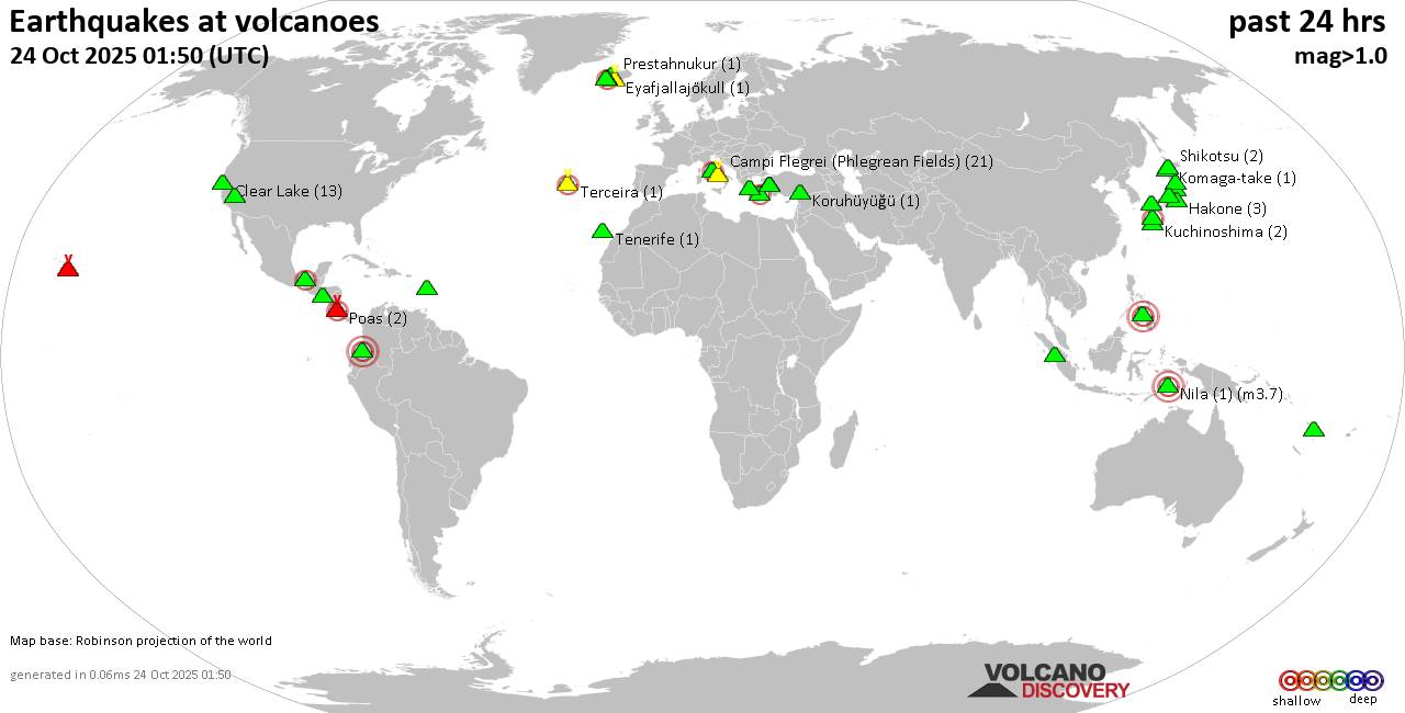
World map showing volcanoes with shallow (less than 50 km) earthquakes within 20 km radius during the past 24 hours on 24 Oct 2025 Number in brackets indicate nr of quakes.

Quakes detected near: Abu (29 quakes between mag 0.1-1.3), Akagi (2 quakes between mag 0.2-1.4), Akita-Yake-yama (1 quake mag 1.1), Akuseki-jima (1 quake mag 3.1), Bardarbunga (10 quakes between mag 0.2-2.0), Barva (1 quake mag 3.0)
Brennisteinsfjöll (6 quakes between mag 0.3-1.0), Bulusan (1 quake mag 1.9), Campi Flegrei (Phlegrean Fields) (19 quakes between mag 0.1-1.7), Canlaon (2 quakes between mag 2.1-3.0), Cerro Negro de Mayasquer (2 quakes between mag 1.3-1.5), Cerro Singüil (1 quake mag 2.0), Chaîne des Puys (2 quakes between mag 1.1-1.3), Clear Lake (32 quakes between mag 0.2-2.0), Coso (1 quake mag 1.5), El Chichón (18 quakes between mag 1.7-2.9), El Hierro (2 quakes between mag 2.1-2.3), Eldey (1 quake mag 1.0), Epi (1 quake mag 2.7), Gran Canaria (1 quake mag 1.1), Kaguyak (2 quakes between mag 1.6-1.8), Katla (3 quakes between mag 0.6-1.2), Kilauea (2 quakes between mag 1.7-1.9), Kirishima (3 quakes between mag 0.5-1.4), Kolumbo (3 quakes between mag 1.4-1.5), Koruhüyüğü (1 quake mag 2.0), Kozushima (1 quake mag 1.9), Krísuvík (12 quakes between mag 0.1-1.2), Laguna Aramuaca (6 quakes between mag 1.9-2.3), Ljósufjöll (6 quakes between mag

Click this link to continue reading the article on the source website.
RSS feed source: Volcano Discovery.com--Global earthquake monitor

Date and TimeMag
DepthDistanceLocationDetailsMap Oct 10, 05:21 am (GMT +9)

4.6

115 km68 km (42 mi) to the E Banda Sea InfoOct 4, 03:00 am (Jayapura)

4.0

138 km10.2 km (6.3 mi) to the E Banda Sea InfoOct 2, 02:38 pm (Jayapura)

4.1

162 km8.5 km (5.3 mi) to the SE Banda Sea InfoOct 1, 10:49 pm (Jayapura)

5.6

151 km94 km (58 mi) to the NE 197 km NE of Lospalos, Timor Leste 6 reportsInfoSep 27, 11:02 pm (GMT +9)

4.5

181 km71 km (44 mi) to the E Banda Sea InfoSep 3, 06:51 pm (Jayapura)

4.5

109 km9.5 km (5.9 mi) to the S Banda Sea InfoSep 1, 02:31 am (GMT +9)

4.6

171 km26 km (16 mi) to the E Banda Sea InfoNov 8, 2023 01:53 pm (GMT +9)

7.1

6 km261 km (162 mi) to the NE Banda Sea InfoJan 10, 2023 02:47 am (Jayapura)

7.9

131 km291 km (181 mi) to the E Banda Sea, 101 km northeast of Pulau Wetan Island, Maluku, Indonesia 880 reportsInfoMay 27, 2022 11:36 am (GMT +9)

6.2

49 km72 km (45 mi) to the SW Banda Sea, 37 km northeast of Lospalos, Lautein, Timor-Leste 246 reportsInfoFeb 2, 2022 04:25 am (GMT +9)

6.0

119 km85 km (53 mi) to the E Banda Sea, 101 km east of Pulau Romang Island, Maluku, Indonesia 55 reportsInfoDec 30, 2021 03:25 am (Jayapura)

7.3

165 km19 km (12 mi) to the N 125 km NNE of Lospalos, Timor Leste 1221 reportsInfoJun 24, 2019 11:53 am (Jayapura)

7.3

214 km228 km (142 mi) to the NE Banda Sea 186 reportsInfoDec 21, 2016 09:17 am (GMT +9)

6.6

164 km37 km (23 mi) to the E Banda Sea 30 reportsInfoAug 6, 2014 11:45 am (Universal Time)

6.2

20 km76 km (47 mi) to

Click this link to continue reading the article on the source website.

RSS feed source: Volcano Discovery.com--Global earthquake monitor

Date and TimeMag
DepthDistanceLocationDetailsMap Oct 12, 09:20 am (GMT +10)

4.7

10 km32 km (20 mi) to the E 108 km S of Merizo Village, Guam InfoAug 31, 05:42 pm (GMT +11)

4.3

10 km65 km (41 mi) to the S South of Mariana Islands InfoAug 21, 12:42 pm (GMT +10)

4.5

35 km44 km (27 mi) to the N Guam Region InfoAug 11, 01:24 am (GMT +10)

4.5

87 km66 km (41 mi) to the N 82 km SW of Merizo Village, Guam InfoJul 25, 11:45 pm (GMT +10)

4.2

41 km71 km (44 mi) to the NE Santa Rita Municipality, 93 km south of Dededo Village, Dededo, Guam 9 reportsInfoMay 26, 04:50 pm (GMT +10)

5.1

10 km38 km (23 mi) to the SW 155 km SSW of Merizo Village, Guam InfoApr 28, 11:04 am (GMT +11)

5.0

10 km67 km (42 mi) to the SW 180 km SW of Merizo Village, Guam InfoDec 27, 2024 07:30 pm (GMT +10)

5.3

10 km30 km (19 mi) to the W 146 km SSW of Merizo Village, Guam 2 reportsInfoNov 22, 2024 02:39 am (GMT +11)

5.0

10 km61 km (38 mi) to the S 176 km SSW of Merizo Village, Guam InfoOct 3, 2024 01:09 pm (GMT +10)

5.0

10 km25 km (16 mi) to the W143 km SSW of Merizo Village, Guam InfoOct 20, 2023 10:04 am (GMT +10)

5.7

17 km95 km (59 mi) to the W Philippine Sea, 190 km southwest of Guam Island, Guam InfoFeb 14, 2022 07:29 am (GMT +11)

6.0

15 km50 km (31 mi) to the S North Pacific Ocean, 197 km south of Tamuning-Tumon-Harmon Village, Guam 10 reportsInfoJul 22, 2019 03:35 am (GMT +10)

5.6

46 km13 km

Click this link to continue reading the article on the source website.

RSS feed source: Volcano Discovery.com--Global earthquake monitor

The chair of the Department of Manufacturing and Industrial Systems Engineering provides leadership to the department in setting and achieving goals and objectives that fulfill the department’s mission and align with the strategic priorities of the College and University.

The Department of Manufacturing and Industrial Systems Engineering (MISE) at Tennessee Tech University is a new unit created from the merger of Manufacturing Engineering Technology and Industrial Systems Engineering. The combined unit has a BS in Engineering Technology (ABET accredited) with a strong emphasis in manufacturing, a joint BS in General Engineering with East Tennessee State University (ABET accredited), a minor in Industrial Systems Engineering, an MS in Engineering Management, and is expected to have an MS in Industrial Systems Engineering approved before this position is filled. The combined enrollment is 344 students. The combined department also has 11 faculty lines (including the chair) and

Click this link to continue reading the article on the source website.