RSS feed source: Volcano Discovery.com--Global earthquake monitor

Sat, 23 Aug 2025, 00:24 | BY: EARTHQUAKEMONITOR

Worldwide earthquakes above magnitude 3 during the past 24 hours on 23 Aug 2025

Summary: 1 quake 7.0+, 7 quakes 5.0+, 43 quakes 4.0+, 138 quakes 3.0+, 347 quakes 2.0+ (536 total)
A powerful magnitude 7.5 earthquake struck the Drake Passage—between South America and Antarctica—early today, triggering a tsunami alert for parts of Chile’s coastline. The Pacific Tsunami Warning Center warned of possible waves within three hours, and authorities remain on alert (Economic Times).
Meanwhile, aggregated data show a particularly active seismic day, with at least one quake above M7, around five above M5, and dozens more in the moderate range. According to our monitoring system, more than 1,800 earthquakes were detected in the past 24 hours, underscoring the global scale of seismic activity.
Other noteworthy tremors included a M5.3 near Mawlaik, Myanmar, and several magnitude-5 events in the South Shetland Islands region. While these quakes drew scientific attention, no major damage or casualties have been reported.
Despite the high numbers, today’s seismic activity was otherwise geographically dispersed and largely non-impactful—save for the Drake Passage and tsunami advisory, which remains the most significant event of the day.
Magnitude 7+: 1 earthquake
Magnitude 5+: 7 earthquakes
Magnitude 4+: 43 earthquakes
Magnitude 3+: 138 earthquakes
Magnitude 2+: 347 earthquakes
No quakes of magnitude 6 or higherTotal seismic energy estimate: 1.1 x 10¹⁶ joules (3130 gigawatt hours, equivalent to

Click this link to continue reading the article on the source website.

RSS feed source: Volcano Discovery.com--Global earthquake monitor

Date and TimeMag
DepthDistanceLocationDetailsMap Aug 16, 10:52 am (GMT -12)

5.5

35 km35 km (21 mi) to the W South Pacific Ocean, 369 km south of ‘Eua Island, Eua, TongaI FELT IT InfoMay 19, 03:24 am (GMT -12)

5.1

10 km59 km (37 mi) to the E South of Tonga InfoNov 27, 2024 04:27 am (GMT +12)

4.4

10 km54 km (34 mi) to the NESouth of Tonga InfoAug 24, 2024 11:05 pm (GMT +12)

4.4

10 km57 km (35 mi) to the N South of Tonga InfoMar 30, 2024 09:12 am (GMT +12)

4.9

10 km49 km (30 mi) to the E South of Tonga InfoJun 25, 2023 12:58 pm (GMT +12)

5.4

10 km52 km (33 mi) to the N South of Tonga 1 reportInfoApr 14, 2022 07:03 pm (GMT +12)

5.5

8 km59 km (37 mi) to the S South of Tonga InfoMar 7, 2021 08:49 pm (Universal Time)

5.3

10 km118 km (73 mi) to the SE near Magnitude 5.3, Near of North Shore InfoMar 19, 2018 01:20 am (GMT +12)

5.1

10 km35 km (22 mi) to the NW south of Tonga InfoMar 15, 2017 08:31 am (GMT +12)

5.1

10 km34 km (21 mi) to the N South of Tonga InfoNov 24, 2015 02:46 pm (GMT +12)

5.5

10 km32 km (20 mi) to the W South of Tonga Islands 1 reportInfoSep 25, 2013 11:38 am (GMT +12)

5.4

10.1 km54 km (34 mi) to the NE South of Tonga InfoMay 24, 2013 11:10 pm (GMT +12)

5.9

10 km75 km (47 mi) to the NE South of Tonga InfoJul 15, 2011 12:55 pm (GMT +12)

5.3

38 km62 km (38 mi) to the NE South of Tonga InfoNov 2, 2009 10:47 pm (GMT +12)

6.2

9 km75 km (47 mi)

Click this link to continue reading the article on the source website.

RSS feed source: Volcano Discovery.com--Global earthquake monitor

Date and TimeMag
DepthDistanceLocationDetailsMap Aug 12, 10:14 am (Makassar)

5.2

260 km97 km (60 mi) to the NW Kabupaten Bone Bolango, 36 km southeast of Gorontalo, Indonesia 1 reportInfoAug 4, 04:57 am (GMT +8)

4.0

62 km72 km (45 mi) to the W Minahassa Peninsula, Sulawesi InfoAug 3, 04:34 am (GMT +8)

4.4

113 km94 km (58 mi) to the W Minahassa Peninsula, Sulawesi InfoAug 2, 06:26 am (GMT +8)

4.4

10 km34 km (21 mi) to the SE Maluku Sea, 166 km southeast of Gorontalo, Kota Gorontalo, Gorontalo, Indonesia InfoJul 31, 07:40 pm (Makassar)

4.0

170 km31 km (19 mi) to the N Minahassa Peninsula, Sulawesi InfoJul 28, 10:42 am (Makassar)

4.2

223 km70 km (43 mi) to the NW Minahassa Peninsula, Sulawesi InfoJul 21, 12:50 pm (GMT +8)

4.9

146 km90 km (56 mi) to the W 70 km south of Gorontalo, Kota Gorontalo, Gorontalo, Indonesia InfoFeb 26, 06:55 am (GMT +8)

6.1

28 km98 km (61 mi) to the NE Maluku Sea, 130 km south of Manado, Kota Manado, Sulawesi Utara, Indonesia 19 reportsInfoNov 6, 2021 10:37 pm (Makassar)

6.0

44 km35 km (22 mi) to the E Indonesia: Southern Molucca Sea 5 reportsInfoJun 23, 2020 03:43 pm (Makassar)

6.0

108 km38 km (24 mi) to the NW Minahassa Peninsula, Sulawesi 13 reportsInfoJan 20, 2020 12:58 am (Makassar)

6.1

132 km21 km (13 mi) to the W Minahassa Peninsula, Sulawesi 18 reportsInfoDec 17, 2012 05:16 pm (GMT +8)

6.1

44 km70 km (44 mi) to the SW 118 km ENE of Luwuk, Indonesia InfoDec 12, 2008 05:40 am (GMT +8)

5.9

129 km74 km (46 mi) to the W Minahasa, Sulawesi, Indonesia InfoNov 17, 2008 01:02 am (Makassar)

7.4

30 km267 km (166 mi) to the NW Celebes Sea, Sulawesi

Click this link to continue reading the article on the source website.
RSS feed source: Volcano Discovery.com--Global earthquake monitor

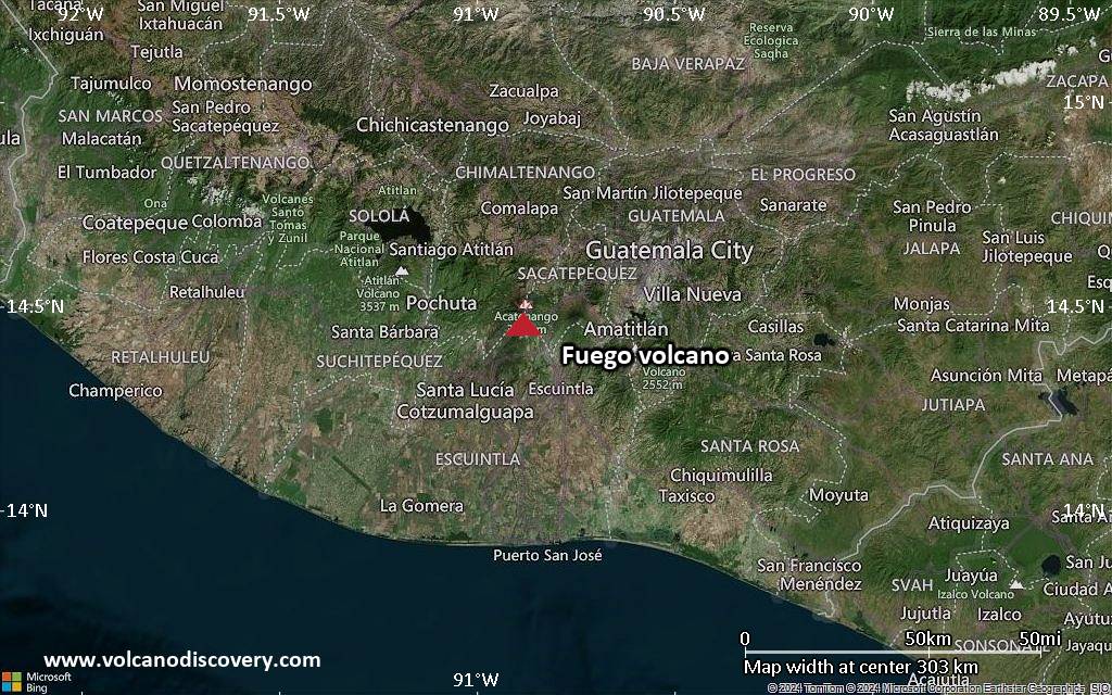
<!–div style="font-size:14px;text-align:center;border:3px solid blue;border-radius:5px;padding:3px;margin:5px;background:#eee"><a href="https://www.volcanoesandearthquakes.com/app/volcano-report.php?volcanoId=26" style="text-decoration:none" target="_blank" rel="noopener noreferrer nofollow" title="Share a volcano (activity) report, submit a photo or other interesting news!” onclick=”window.open(this.href,’Volcano Report’,’status=0,toolbar=0,location=0,directories=0,menubar=0,resizable=1,scrollbars=1,height=500,width=450′);return false”>Send Volcano Report</div–> Stratovolcano 3,763 m / 12,346 ft
Guatemala, 14.47°N / -90.88°W
Current status: erupting (4 out of 5) Fuego volcano eruptions:
1581, 1585, 1586, 1587, 1614, 1617, 1620, 1623, 1629, 1679(?), 1685, 1686, 1689(?), 1699, 1702, 1705, 1706, 1709(?), 1710,1717,1730, 1732, 1737, 1751(?), 1765(?), 1773(?), 1799, 1826, 1829, 1850(?), 1852(?), 1855, 1856, 1857, 1860, 1861(?), 1867(?), 1880, 1896, 1932, 1944, 1949, 1953, 1955, 1957, 1962, 1963, 1966, 1967, 1971, 1973, 1974, 1975, 1977, 1987, 1999, 2002 – ongoing
Typical eruption style
Dominantly explosive, construction of lava domes and extrusion of viscous lava flows. In near constant activity, at least during the past centuries.

Click this link to continue reading the article on the source website.