RSS feed source: USGS Earthquake Hazards Program
Time2025-11-22 00:00:27 UTC2025-11-22 00:00:27 UTC at epicenterLocation6.573°N 125.426°EDepth214.07 km (133.02 mi)
Click this link to continue reading the article on the source website.
RSS feed source: USGS Earthquake Hazards Program
Time2025-11-22 00:00:27 UTC2025-11-22 00:00:27 UTC at epicenterLocation6.573°N 125.426°EDepth214.07 km (133.02 mi)
Click this link to continue reading the article on the source website.
RSS feed source: USGS Earthquake Hazards Program
Saturday, Nov 22, 2025 00:07 | 20 mins ago | By: EarthquakeMonitor
An earthquake of magnitude 4.7 occurred in the morning on Saturday, November 22nd, 2025, at 8:00 am local time near Malita, Davao Occidental, Davao, Philippines, as reported by Indonesia’s Meteorology, Climatology, and Geophysical Agency.
According to preliminary data, the quake was located at an intermediate to considerable depth of 189. km. The strength of the earthquake may have been tempered by its relative great depth below the surface, which makes it feel weaker in absolute terms. The exact magnitude, epicenter, and depth of the quake might be revised within the next few hours or minutes as seismologists review data and refine their calculations, or as other agencies issue their report.
Towns or cities near the epicenter where the quake might have been felt as very weak shaking include Malita (pop. 41,100) located 4 km from the epicenter, Santa Maria (pop. 16,800) 23 km away, Malungun (pop. 52,200) 43 km away, Digos (pop. 116,100) 47 km away, General Santos (pop. 697,300) 63 km away, Davao City (pop. 1,776,900) 72 km away, Samal (pop. 43,500) 72 km away, Mati (pop. 105,900) 86 km away, and Panabo (pop. 84,700) 98 km away.
VolcanoDiscovery will automatically update magnitude and depth if these change and follow up if other significant news about the quake become available. If
Click this link to continue reading the article on the source website.
RSS feed source: USGS Earthquake Hazards Program
Date and TimeMag
DepthDistanceLocationDetailsMap Nov 16, 02:35 pm (Manila)
4.5
86 km79 km (49 mi) to the E Philippine Sea, 54 km south of Mati, Philippines I FELT IT – 1 reportInfoNov 7, 10:27 am (GMT +8)
4.2
135 km101 km (63 mi) to the SE Mindanao, Philippines InfoNov 4, 10:30 pm (Manila)
4.4
27 km76 km (47 mi) to the S Province of Sarangani, 42 km southeast of General Santos, Philippines InfoOct 16, 05:32 am (Manila)
4.4
158 km47 km (29 mi) to the SE Philippine Sea, 20 km southeast of Malita, Davao Occidental, Davao, Philippines InfoOct 10, 08:48 pm (Manila)
4.0
112 km64 km (40 mi) to the S Province of Sarangani, 30 km southeast of General Santos, Philippines InfoOct 10, 09:43 am (Manila)
7.4
58 km166 km (103 mi) to the NE Philippine Sea, 24 km east of Manay, Philippines 451 reportsInfoSep 29, 11:00 am (GMT +8)
4.9
117 km93 km (58 mi) to the SE Philippine Sea, 67 km southeast of Malita, Davao Occidental, Davao, Philippines 1 reportInfoJul 23, 06:21 pm (Manila)
4.9
138 km76 km (47 mi) to the E Philippine Sea, 58 km south of Mati, Philippines 1 reportInfoJun 23, 07:34 am (GMT +8)
4.7
86 km121 km (75 mi) to the E Philippine Sea, 86 km south of Mati, Philippines InfoJun 18, 03:49 am (Manila)
4.7
52 km88 km (55 mi) to the S Philippine Sea, 45 km northeast of Sarangani Island, Philippines InfoMay 26, 06:48 pm (GMT +8)
4.9
98 km125 km (78 mi) to the SE Philippine Sea, 83 km northeast of Sarangani Island, Philippines InfoJul 11, 2024 10:13 am (GMT +8)
7.1
640 km257 km (160 mi) to the W 98 km WSW
Click this link to continue reading the article on the source website.
RSS feed source: USGS Earthquake Hazards Program
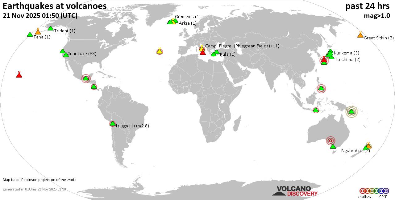
Friday, Nov 21, 2025 23:50 | 4 hours ago | By: EarthquakeMonitor
World map showing volcanoes with shallow (less than 50 km) earthquakes within 20 km radius during the past 24 hours on 21 Nov 2025 Number in brackets indicate nr of quakes.
Quakes detected near: Akuseki-jima (2 quakes between mag 1.7-2.0), Aniakchak (2 quakes between mag 1.0-1.3), Bardarbunga (2 quakes between mag 1.2-3.0), Biliran (1 quake mag 2.6), Binuluan (1 quake mag 1.6), Brennisteinsfjöll (2 quakes between mag 0.8-1.1)
Campi Flegrei (Phlegrean Fields) (9 quakes between mag 0.1-1.3), Clear Lake (36 quakes between mag 0.2-1.9), Coso (2 quakes between mag 1.4-1.9), Don Joao de Castro Bank (1 quake mag 2.5), El Chichón (17 quakes between mag 1.7-2.6), Eldey (5 quakes between mag 1.1-2.1), Fagradalsfjall (1 quake mag 1.2), Galeras (1 quake mag 3.0), Katla (4 quakes between mag 0.5-1.5), Kilauea (2 quakes between mag 1.2-2.2), Komaga-take (2 quakes between mag 0.6-1.6), Krafla (2 quakes between mag 0.3-1.3), Krísuvík (11 quakes between mag 0.2-2.2), Ljósufjöll (4 quakes between mag 0.7-1.0), Los Humeros (1 quake mag 3.0), Mammoth Mountain (1 quake mag 1.1), Mauna Kea (1 quake mag 1.7), Maunaloa (1 quake mag 1.8), Mayotte Island (1 quake mag 1.4), Mount Rainier (7 quakes between mag 0.3-2.2), Nantai (1 quake mag 1.1), Nejapa-Miraflores (1 quake mag 3.0), Nipesotsu-Maruyama (6 quakes between mag 0.9-2.7), Ontake-san
Click this link to continue reading the article on the source website.