RSS feed source: US National Weather Service

…WINTER WEATHER ADVISORY IN EFFECT UNTIL NOON CST TODAY… .Webcams along the Interstate 94 corridor in west-central Wisconsin have begun showing a switch from rain to snow. Accumulations will be mostly confined to elevated or cold-grassy surfaces. Should snowfall rates pick up, accumulating snowfall on secondary roads is possible. Some impacts to the morning commute should be planned for with reduced visibilities and the potential for slippery travel. * WHAT…Wet snow. Additional snow accumulations up to two inches. * WHERE…Adams, Clark, Juneau, Jackson, and Monroe Counties. * WHEN…Until noon CST today. * IMPACTS…Plan on slippery road conditions. The hazardous conditions could impact the Tuesday morning commute.

Click this link to continue reading the article on the source website.

RSS feed source: US National Weather Service

Date and TimeMag
DepthDistanceLocationDetailsMap Nov 11, 04:14 am (GMT +9)

5.0

172 km86 km (53 mi) to the SE Banda Sea, 126 km northeast of Pulau Dai Island, Maluku, Indonesia InfoNov 5, 09:56 pm (GMT +9)

4.7

148 km86 km (53 mi) to the E Banda Sea, 137 km northwest of Pulau Molu Island, Maluku, Indonesia InfoOct 27, 09:26 pm (GMT +9)

4.0

189 km80 km (50 mi) to the SE Banda Sea, 145 km northwest of Pulau Maru Island, Maluku, Indonesia InfoOct 22, 08:43 pm (GMT +9)

4.4

280 km96 km (60 mi) to the NW Banda Sea, 154 km southwest of Pulau Banda Besar Island, Maluku, Indonesia InfoOct 18, 05:30 am (GMT +9)

4.5

169 km87 km (54 mi) to the N Banda Sea, 69 km south of Pulau Banda Besar Island, Maluku, Indonesia InfoOct 15, 09:30 am (GMT +9)

4.7

199 km87 km (54 mi) to the SE Banda Sea, 124 km northeast of Pulau Dai Island, Maluku, Indonesia InfoNov 11, 2023 03:41 pm (GMT +9)

5.7

10 km57 km (35 mi) to the NE Banda Sea, 254 km north of Pulau Wetan Island, Maluku, Indonesia 1 reportInfoNov 11, 2023 05:45 am (GMT +9)

6.1

10 km44 km (27 mi) to the SE Banda Sea, 209 km north of Pulau Wetan Island, Maluku, Indonesia InfoNov 10, 2023 12:50 pm (GMT +9)

5.9

10 km58 km (36 mi) to the E Banda Sea, 223 km north of Pulau Wetan Island, Maluku, Indonesia InfoNov 8, 2023 10:02 pm (Jayapura)

6.7

10 km29 km (18 mi) to the SE Banda Sea, 201 km north of Pulau Wetan Island, Maluku, Indonesia 1 reportInfoNov 8,

Click this link to continue reading the article on the source website.
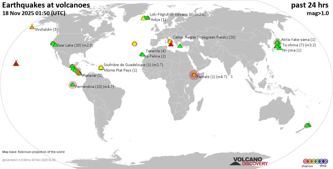
RSS feed source: US National Weather Service

Tuesday, Nov 18, 2025 08:50 | 53 mins ago | By: EarthquakeMonitor

World map showing volcanoes with shallow (less than 50 km) earthquakes within 20 km radius during the past 24 hours on 18 Nov 2025 Number in brackets indicate nr of quakes.

Quakes detected near: Akita-Yake-yama (1 quake mag 1.0), Apaneca Range (2 quakes between mag 2.3-2.5), Askja (1 quake mag 1.0), Barva (1 quake mag 1.7), Campi Flegrei (Phlegrean Fields) (24 quakes between mag 0.1-2.4), Clear Lake (18 quakes between mag 0.5-1.4)
Cofre de Perote (1 quake mag 3.1), Coso (3 quakes between mag 0.8-1.1), El Chichón (8 quakes between mag 1.4-2.2), Erciyes Dagi (2 quakes between mag 1.2-1.6), Etna (7 quakes between mag 1.6-2.6), Fantale (1 quake mag 4.5), Fernandina (9 quakes between mag 2.6-3.9), Haku-san (2 quakes between mag 0.3-1.9), Kilauea (3 quakes between mag 1.7-1.9), Kolumbo (4 quakes between mag 1.5-1.8), Krísuvík (5 quakes between mag 0.3-1.1), Ljósufjöll (3 quakes between mag 0.0-2.3), Loki-Fögrufjöll volcano (2 quakes between mag 1.1-1.2), Mauna Kea (1 quake mag 1.9), Maunaloa (1 quake mag 1.3), Megata (1 quake mag 3.0), Morne Plat Pays (1 quake mag 1.5), Nantai (2 quakes between mag 0.4-1.1), Nejapa-Miraflores (1 quake mag 3.0), Nii-jima (2 quakes between mag 1.1-1.7), Prestahnukur (2 quakes between mag 1.3-1.4), Ruapehu (1 quake mag 1.2), Santorini (1 quake mag 1.3), Shishaldin (2

Click this link to continue reading the article on the source website.

RSS feed source: US National Weather Service

Date and TimeMag
DepthDistanceLocationDetailsMap Nov 11, 11:38 pm (GMT -9)

4.2

10 km77 km (48 mi) to the NW North Pacific Ocean, 189 mi west of Coos Bay, Coos County, Oregon, United StatesI FELT IT InfoNov 4, 07:21 pm (GMT -8)

4.0

10 km46 km (29 mi) to the E North Pacific Ocean, 185 mi west of Eugene, Lane County, Oregon, United States InfoSep 28, 11:31 pm (GMT -9)

4.0

10 km72 km (45 mi) to the W North Pacific Ocean, 197 mi west of Coos Bay, Coos County, Oregon, United States InfoSep 27, 02:12 pm (GMT -8)

5.1

10 km15 km (9.5 mi) to the SE North Pacific Ocean, 147 mi west of Coos Bay, Coos County, Oregon, United States InfoSep 25, 10:45 pm (GMT -8)

5.9

10 km9.5 km (5.9 mi) to the SE North Pacific Ocean, 231 mi southwest of Salem, Marion County, Oregon, United States 3 reportsInfoJul 3, 11:42 pm (GMT -8)

4.2

10 km55 km (34 mi) to the SE North Pacific Ocean, 215 mi southwest of Salem, Marion County, Oregon, United States 1 reportInfoJun 26, 03:24 am (GMT -9)

4.4

10 km59 km (37 mi) to the NW North Pacific Ocean, 190 mi west of Coos Bay, Coos County, Oregon, United States InfoOct 30, 2024 11:15 am (GMT -9)

6.0

10 km28 km (18 mi) to the W North Pacific Ocean, 247 mi west of Salem, Marion County, Oregon, United States 8 reportsInfoApr 29, 2021 01:58 am (GMT -9)

5.3

10 km100 km (62 mi) to the NW North Pacific Ocean, 276 mi west of Salem, Marion County, Oregon, United States

Click this link to continue reading the article on the source website.