RSS feed source: Volcano Discovery.com--Global earthquake monitor

Date and TimeMag
DepthDistanceLocationDetailsMap Nov 8, 09:40 pm (Makassar)

4.2

114 km74 km (46 mi) to the S 18 km southwest of Dompu, Kabupaten Dompu, West Nusa Tenggara, Indonesia InfoNov 4, 12:58 am (Makassar)

4.3

13 km4.6 km (2.8 mi) to the S Flores Sea, 75 km northwest of Bima, Kota Bima, West Nusa Tenggara, Indonesia InfoOct 1, 11:31 am (Makassar)

4.9

165 km39 km (24 mi) to the S 53 km west of Dompu, Kabupaten Dompu, West Nusa Tenggara, Indonesia InfoSep 13, 04:39 am (Makassar)

4.1

113 km70 km (43 mi) to the SE 12 km southwest of Dompu, Kabupaten Dompu, West Nusa Tenggara, Indonesia InfoSep 8, 10:01 pm (GMT +8)

4.1

13 km51 km (31 mi) to the W Flores Sea, 42 km north of Pulau Moyo Island, West Nusa Tenggara, Indonesia InfoAug 29, 2023 03:55 am (Makassar)

7.1

525 km213 km (133 mi) to the NW Java Sea, 86 km east of Pulau Sepanjang Island, Jawa Timur, Indonesia 2473 reportsInfoApr 2, 2023 04:40 pm (GMT +8)

5.6

10.9 km66 km (41 mi) to the NE Flores Sea, 60 km northwest of Pulau Sangeang Island, Indonesia 8 reportsInfoAug 1, 2016 07:40 am (Makassar)

5.3

20 km36 km (22 mi) to the SW Kabupaten Bima, 57 km northeast of Sumbawa Besar, Indonesia 11 reportsInfoNov 9, 2012 11:07 pm (Makassar)

5.3

35 km59 km (37 mi) to the W Flores Sea, 44 km southeast of Pulau Sailus Kecil Island, Indonesia InfoMay 8, 2010 11:22 am (Makassar)

5.9

12 km13 km (8.3 mi) to the E Flores Sea, 55 km northwest of Dompu, Indonesia InfoNov 9, 2009 03:41 am (Makassar)

6.6

18 km56 km (35 mi) to the E

Click this link to continue reading the article on the source website.

RSS feed source: Volcano Discovery.com--Global earthquake monitor

Sunday, Nov 16, 2025 00:50 | 49 mins ago | By: EarthquakeMonitor

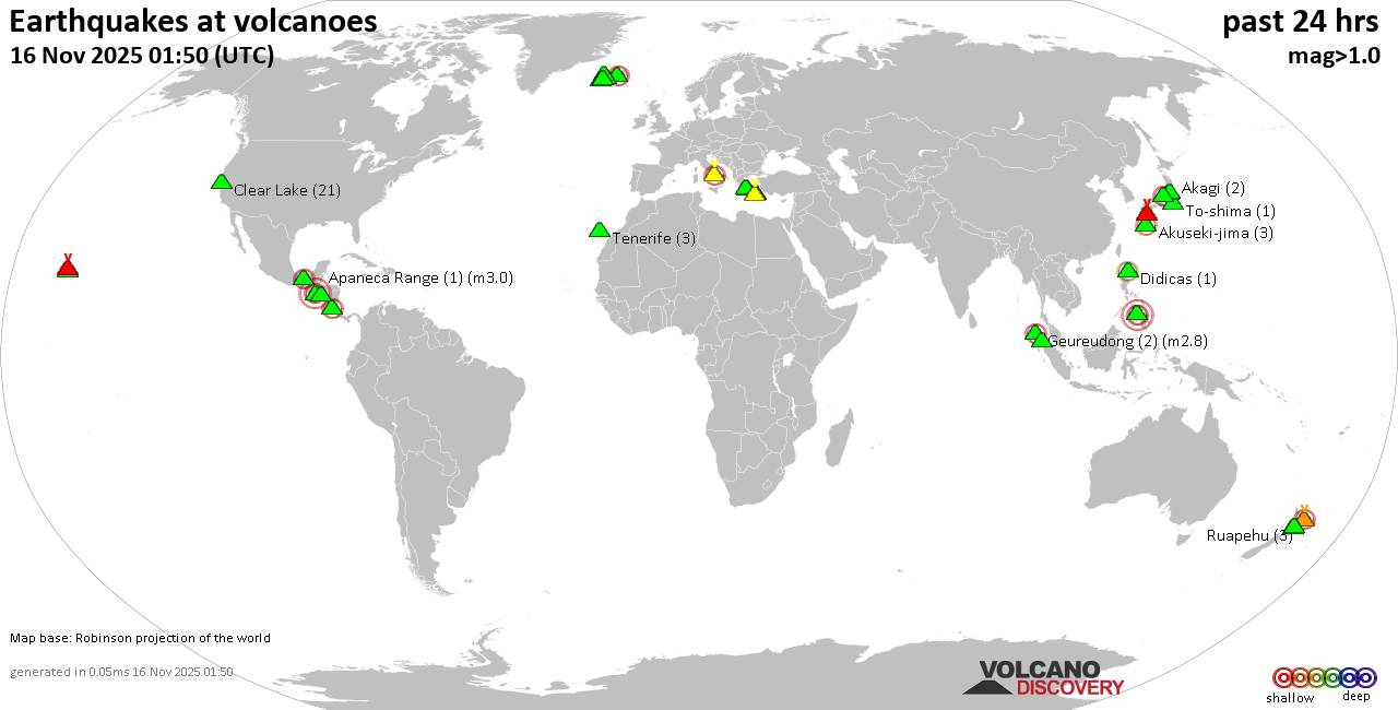
World map showing volcanoes with shallow (less than 50 km) earthquakes within 20 km radius during the past 24 hours on 16 Nov 2025 Number in brackets indicate nr of quakes.

Quakes detected near: Akagi (2 quakes between mag 0.3-1.3), Akuseki-jima (4 quakes between mag 1.1-2.0), Apaneca Range (1 quake mag 3.0), Bardarbunga (7 quakes between mag 0.1-2.8), Campi Flegrei (Phlegrean Fields) (21 quakes between mag 0.1-2.1), Clear Lake (20 quakes between mag 0.2-1.4)
Cuernos de Negros (3 quakes between mag 3.0-3.0), Didicas (1 quake mag 2.2), El Chichón (11 quakes between mag 1.4-3.6), Eldey (8 quakes between mag 1.2-1.7), Geureudong (2 quakes between mag 2.7-2.8), Hrómundartindur (10 quakes between mag 0.1-1.2), Kilauea (3 quakes between mag 1.7-2.4), Kirishima (7 quakes between mag 0.2-1.2), Kolumbo (3 quakes between mag 1.2-2.1), Krísuvík (3 quakes between mag 0.0-1.0), Laguna Aramuaca (1 quake mag 2.0), Ljósufjöll (3 quakes between mag 0.3-1.3), Loihi (1 quake mag 1.7), Methana (1 quake mag 1.3), Nantai (1 quake mag 1.1), Ruapehu (2 quakes between mag 0.8-1.3), Santorini (1 quake mag 1.7), Sinabung (1 quake mag 2.0), Sousaki (1 quake mag 1.2), Suoh (1 quake mag 2.3), Tenerife (3 quakes between mag 1.1-1.5), Tongariro (1 quake mag 1.0), White Island (1 quake mag 2.5), Yake-dake (14 quakes between

Click this link to continue reading the article on the source website.
RSS feed source: Volcano Discovery.com--Global earthquake monitor

<!–div style="font-size:14px;text-align:center;border:3px solid blue;border-radius:5px;padding:3px;margin:5px;background:#eee"><a href="https://www.volcanoesandearthquakes.com/app/volcano-report.php?volcanoId=44" style="text-decoration:none" target="_blank" rel="noopener noreferrer nofollow" title="Share a volcano (activity) report, submit a photo or other interesting news!” onclick=”window.open(this.href,’Volcano Report’,’status=0,toolbar=0,location=0,directories=0,menubar=0,resizable=1,scrollbars=1,height=500,width=450′);return false”>Send Volcano Report</div–> Stratovolcano 3676 m (12,060 ft)
East Java, Indonesia, -8.11°S / 112.92°E
Current status: erupting (4 out of 5) Semeru volcano eruptions:
1818, 1829, 1830, 1832, 1836, 1838, 1842, 1844, 1845, 1848, 1849(?), 1851, 1856, 1857, 1865, 1866(?), 1887, 1887, 1888, 1889-91, 1892, 1893, 1893-94, 1895, 1896, 1897, 1899, 1899, 1900, 1901, 1903, 1904, 1905, 1907, 1908, 1909-10, 1910-11, 1911, 1912, 1913, 1941-42, 1945, 1946, 1946-47, 1950-64, 1967-ongoing
Typical eruption style
Explosive. Near constant strombolian activity, occasionally stronger explosions, lava flows and pyroclastic flows.

Click this link to continue reading the article on the source website.

RSS feed source: Volcano Discovery.com--Global earthquake monitor

Date and TimeMag
DepthDistanceLocationDetailsMap Nov 15, 08:24 pm (GMT +13)

4.0

300 km73 km (46 mi) to the SW Bay of Plenty, New ZealandI FELT IT InfoNov 7, 05:27 pm (GMT +13)

4.4

300 km48 km (30 mi) to the E Hawke’s Bay, New Zealand InfoOct 22, 09:40 pm (GMT +13)

4.1

100 km94 km (58 mi) to the S South Pacific Ocean, Gisborne, 108 km south of Raoul Island, New Zealand InfoOct 22, 05:07 pm (GMT +13)

4.1

300 km95 km (59 mi) to the SE Gisborne, New Zealand InfoOct 15, 10:10 pm (GMT +13)

4.3

33 km73 km (45 mi) to the SW South Pacific Ocean, Gisborne, 63 km south of Raoul Island, New Zealand InfoAug 21, 05:13 am (GMT +12)

4.7

33 km87 km (54 mi) to the S New Zealand InfoJun 27, 01:14 am (GMT +12)

4.8

10 km93 km (58 mi) to the SE South Pacific Ocean, 145 km southeast of Raoul Island, New Zealand InfoJun 8, 01:20 am (GMT +12)

5.0

349 km86 km (54 mi) to the SW New Zealand InfoJun 6, 05:53 am (GMT +12)

4.5

27 km90 km (56 mi) to the SW South Pacific Ocean, 98 km south of Raoul Island, New Zealand InfoJun 1, 2024 03:54 am (GMT +12)

6.1

33 km70 km (43 mi) to the E South Pacific Ocean, Gisborne, 120 km east of Raoul Island, New Zealand 1 reportInfoFeb 9, 2024 11:57 pm (GMT +13)

6.2

10 km32 km (20 mi) to the N South Pacific Ocean, Gisborne, 62 km east of Raoul Island, New Zealand 1 reportInfoApr 24, 2023 12:41 pm (GMT +12)

6.8

33 km88 km (54 mi) to the SE New Zealand 1 reportInfoAug 31,

Click this link to continue reading the article on the source website.