RSS feed source: Volcano Discovery.com--Global earthquake monitor

Mon, 27 Oct 2025, 01:50 | BY: EARTHQUAKEMONITOR

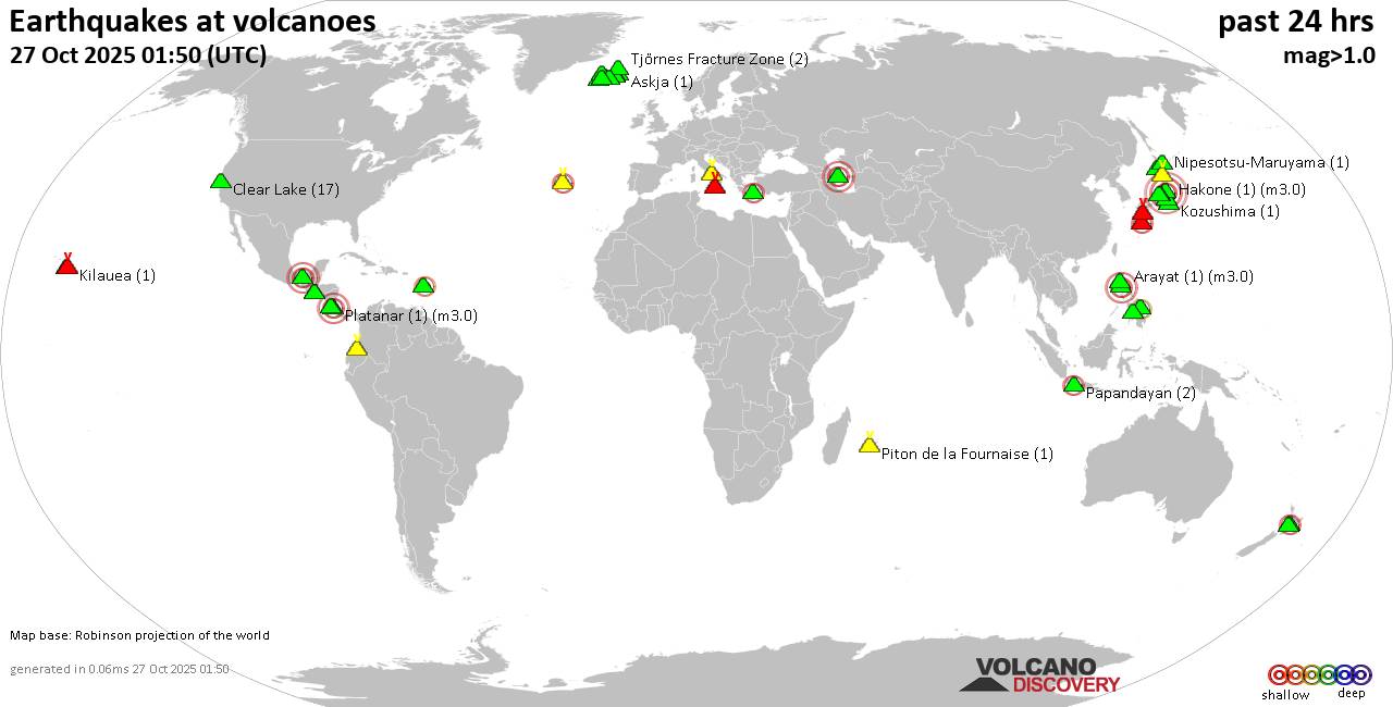
World map showing volcanoes with shallow (less than 50 km) earthquakes within 20 km radius during the past 24 hours on 27 Oct 2025 Number in brackets indicate nr of quakes.

Quakes detected near: Akagi (4 quakes between mag 0.1-4.7), Apaneca Range (2 quakes between mag 1.8-2.1), Arayat (1 quake mag 3.0), Askja (1 quake mag 1.0), Bardarbunga (9 quakes between mag 0.5-1.9), Brennisteinsfjöll (3 quakes between mag 0.9-1.2)
Cabalian (1 quake mag 2.8), Campi Flegrei (Phlegrean Fields) (38 quakes between mag 0.1-1.0), Cerro Negro de Mayasquer (1 quake mag 1.9), Clear Lake (17 quakes between mag 0.6-1.6), Cuernos de Negros (1 quake mag 3.0), El Chichón (11 quakes between mag 1.8-3.4), Eldey (2 quakes between mag 1.0-1.5), Etna (1 quake mag 1.6), Grímsnes (3 quakes between mag 0.3-1.7), Hakone (1 quake mag 3.0), Hrómundartindur (10 quakes between mag 0.4-1.0), Izalco (1 quake mag 1.8), Kilauea (1 quake mag 1.8), Kirishima (5 quakes between mag 0.5-1.3), Kolumbo (1 quake mag 2.6), Komaga-take (2 quakes between mag 0.4-1.7), Kozushima (1 quake mag 1.3), Ljósufjöll (3 quakes between mag 0.9-1.9), Lokbatan (1 quake mag 3.0), Loki-Fögrufjöll volcano (1 quake mag 1.8), Maunaloa (1 quake mag 2.0), Morne Plat Pays (1 quake mag 2.4), Nantai (76 quakes between mag 0.1-3.7), Ngauruhoe (1 quake mag 2.1), Nipesotsu-Maruyama (1 quake mag

Click this link to continue reading the article on the source website.
RSS feed source: Volcano Discovery.com--Global earthquake monitor

Date and TimeMag
DepthDistanceLocationDetailsMap Mar 3, 2023 09:13 am (Shanghai)

4.2

10 km129 km (80 mi) to the W 256 km southwest of Chamdo, Tibet, China InfoSep 18, 2022 06:27 pm (Kolkata)

4.4

10 km132 km (82 mi) to the S Dibang Valley, 97 km northeast of Pasighat, India 1 reportInfoAug 29, 2022 06:24 pm (Kolkata)

4.3

5 km118 km (73 mi) to the S India: Dibang Valley, Arunachal Pradesh InfoMar 15, 2022 10:51 am (Shanghai)

4.1

35 km118 km (73 mi) to the W 238 km southwest of Chamdo, Tibet, China InfoMar 3, 2022 04:47 pm (Shanghai)

4.4

10 km124 km (77 mi) to the W 164 km NNE of Shi Yomi, India InfoAug 12, 2020 11:58 pm (Shanghai)

4.8

21 km113 km (70 mi) to the W 268 km north of Dibrugarh, Assam, India, China InfoApr 7, 2020 06:39 pm (Shanghai)

4.4

10 km125 km (78 mi) to the SW 204 km north of Dibrugarh, Assam, India, China 1 reportInfoFeb 1, 2020 09:43 am (Universal Time)

5.0

10 km103 km (64 mi) to the SW Dibang Valley, 122 km northeast of Pasighat, India 3 reportsInfoDec 20, 2017 01:40 am (Shanghai)

4.9

10 km121 km (75 mi) to the W 240 km southwest of Chamdo, Tibet, China InfoNov 23, 2017 03:13 pm (Shanghai)

4.8

10 km106 km (66 mi) to the W Eastern Xizang-India Border Reg. InfoNov 18, 2017 06:34 am (Shanghai)

6.3

13 km128 km (80 mi) to the W 259 km southwest of Chamdo, Tibet, China 26 reportsInfoNov 29, 2013 07:24 am (Kolkata)

5.0

35 km122 km (76 mi) to the S Dibang Valley, 104 km northeast of Pasighat, India InfoJul 5, 2008 05:35 am (Shanghai)

4.7

35 km65 km (40 mi) to the S

Click this link to continue reading the article on the source website.

RSS feed source: Volcano Discovery.com--Global earthquake monitor

Date and TimeMag
DepthDistanceLocationDetailsMap Sep 14, 09:26 pm (Yangon)

4.6

57 km69 km (43 mi) to the W Chin State, 120 km northeast of Sittwe, Rakhine State, Myanmar 2 reportsInfoMar 28, 12:50 pm (Yangon)

7.7

10 km191 km (119 mi) to the NE 14 km northwest of Sagaing, Sagaing Region, Myanmar 768 reportsInfoFeb 22, 05:03 pm (Yangon)

5.2

55 km80 km (50 mi) to the NW 171 km northeast of Sittwe, Rakhine State, Myanmar 1 reportInfoOct 3, 2024 07:39 am (Yangon)

4.3

103 km97 km (60 mi) to the N 72 km WSW of Monywa, Myanmar 1 reportInfoSep 24, 2024 05:07 pm (Yangon)

4.5

129 km66 km (41 mi) to the E Nay Pyi Taw, 25 km south of Pakokku, Magway Region, Myanmar InfoAug 28, 2024 02:49 am (Yangon)

4.4

114 km66 km (41 mi) to the SE 19 km south of Chauk, Magway Region, Myanmar InfoJul 28, 2024 04:41 pm (Yangon)

4.8

68 km54 km (34 mi) to the NW 106 km northwest of Chauk, Magway Region, Myanmar InfoFeb 12, 2024 03:18 am (Yangon)

4.9

72 km56 km (35 mi) to the NW 102 km NW of Chauk, Myanmar 2 reportsInfoAug 20, 2023 02:12 pm (Yangon)

4.7

61 km51 km (31 mi) to the S 52 km southwest of Chauk, Magway Region, Myanmar InfoSep 6, 2019 04:39 pm (Yangon)

4.8

102 km37 km (23 mi) to the E Myanmar InfoMar 18, 2019 04:54 pm (Universal Time)

5.1

10 km72 km (45 mi) to the E 28 km south of Pakokku, Magway Region, Myanmar 5 reportsInfoNov 19, 2018 10:37 am (Yangon)

4.9

77 km48 km (30 mi) to the N 82 km northwest of Chauk, Magway Region, Myanmar 1 reportInfoAug 24, 2016 05:04

Click this link to continue reading the article on the source website.