RSS feed source: USGS Earthquake Hazards Program
Time2025-11-19 01:38:53 UTC2025-11-19 01:38:53 UTC at epicenterLocation10.871°N 62.757°WDepth122.98 km (76.41 mi)
Click this link to continue reading the article on the source website.
RSS feed source: USGS Earthquake Hazards Program
Time2025-11-19 01:38:53 UTC2025-11-19 01:38:53 UTC at epicenterLocation10.871°N 62.757°WDepth122.98 km (76.41 mi)
Click this link to continue reading the article on the source website.
RSS feed source: USGS Earthquake Hazards Program
Wednesday, Nov 19, 2025 02:04 | 22 mins ago | By: EarthquakeMonitor
Just 24 minutes ago, a 5.2-magnitude earthquake struck near Gueiria, Valdez Municipality, Sucre, Venezuela. The tremor was recorded in the evening on Tuesday, November 18th, 2025, at 9:38 pm local time, at an intermediate depth of 102. km below the surface.
The event was filed by the German Research Centre for Geosciences (GFZ), the first seismological agency to report it.
A second report was later issued by the citizen-seismograph network of RaspberryShake, which listed it as a magnitude 5.2 earthquake as well. A third agency, The Colombian Geological Service (SGC), reported the same quake at magnitude 5.0.
Based on the preliminary seismic data, the quake should not have caused any significant damage, but was probably felt by many people as light vibration in the area of the epicenter.
Weak shaking might have been felt in Yaguaraparo (pop. 13,600) located 34 km from the epicenter, Gueiria (pop. 40,000) 40 km away, Carupano (pop. 167,200) 73 km away, Caripito (pop. 43,400) 92 km away, Casanay (pop. 20,600) 94 km away, and Port of Spain (pop. 49,000) 119 km away.
VolcanoDiscovery will automatically update magnitude and depth if these change and follow up if other significant news about the quake become available. If you’re in the area, please send us your experience through our reporting mechanism,
Click this link to continue reading the article on the source website.
RSS feed source: USGS Earthquake Hazards Program
Date and TimeMag
DepthDistanceLocationDetailsMap Nov 15, 01:33 pm (Makassar)
5.4
40 km41 km (25 mi) to the SW Sulawesi Utara, 300 km northwest of Tobelo, Indonesia I FELT IT – 1 reportInfoNov 3, 12:34 am (GMT +8)
4.1
28 km79 km (49 mi) to the NE Philippine Islands Region InfoNov 1, 12:06 am (GMT +8)
4.3
33 km93 km (58 mi) to the NW Philippine Sea, 93 km northwest of Pulau Karakelang Island, Indonesia InfoOct 31, 12:06 pm (GMT +8)
4.6
21 km90 km (56 mi) to the NW Talaud Islands, Indonesia InfoOct 27, 02:45 am (GMT +8)
4.4
136 km85 km (53 mi) to the NE Talaud Islands, Indonesia InfoApr 22, 07:17 pm (GMT +9)
6.3
123 km87 km (54 mi) to the E Philippine Sea, 121 km northeast of Pulau Kaburuang Island, Indonesia 24 reportsInfoJan 9, 2024 04:48 am (GMT +8)
6.7
63 km99 km (61 mi) to the NW Philippine Sea, 144 km northwest of Pulau Kaburuang Island, Indonesia 59 reportsInfoJan 18, 2023 03:06 pm (Jayapura)
7.1
64 km178 km (111 mi) to the S Maluku Sea, 116 km south of Pulau Kaburuang Island, Sulawesi Utara, Indonesia 13 reportsInfoAug 11, 2021 05:46 pm (GMT +0)
7.0
63 km237 km (147 mi) to the N Philippine Sea, 74 km southeast of Mati, Philippines 617 reportsInfoJan 21, 2021 08:23 pm (GMT +8)
6.7
108 km95 km (59 mi) to the NEPhilippine Sea, 151 km northeast of Pulau Kaburuang Island, Indonesia 466 reportsInfoJan 12, 2016 12:38 am (Makassar)
6.5
18 km56 km (35 mi) to the S Maluku Sea, 15 km northeast of Pulau Kaburuang Island, Sulawesi Utara, Indonesia InfoJun 14, 2009 01:17 pm (Makassar)
6.5
33 km37 km (23 mi) to the
Click this link to continue reading the article on the source website.
RSS feed source: USGS Earthquake Hazards Program
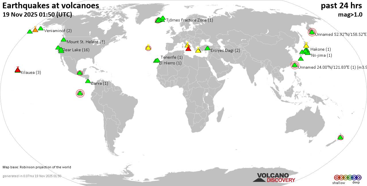
Wednesday, Nov 19, 2025 01:50 | 34 mins ago | By: EarthquakeMonitor
World map showing volcanoes with shallow (less than 50 km) earthquakes within 20 km radius during the past 24 hours on 19 Nov 2025 Number in brackets indicate nr of quakes.
Quakes detected near: Akagi (3 quakes between mag 0.5-1.6), Akuseki-jima (1 quake mag 1.8), Barva (1 quake mag 1.7), Campi Flegrei (Phlegrean Fields) (16 quakes between mag 0.1-1.8), Clear Lake (16 quakes between mag 0.6-1.2), Coso (2 quakes between mag 0.9-1.1)
Daisen (3 quakes between mag 0.3-1.2), El Chichón (2 quakes between mag 1.9-2.1), El Hierro (1 quake mag 1.9), Eldey (112 quakes between mag 0.2-2.3), Erciyes Dagi (2 quakes between mag 1.2-1.6), Etna (1 quake mag 1.3), Fagradalsfjall (2 quakes between mag 0.7-1.1), Fernandina (1 quake mag 3.1), Hakone (1 quake mag 2.1), Hiuchi (7 quakes between mag 0.2-1.0), Hrómundartindur (8 quakes between mag 0.4-1.1), Kilauea (3 quakes between mag 1.7-1.8), Kolumbo (3 quakes between mag 1.5-2.0), Ljósufjöll (4 quakes between mag 0.4-2.6), Loihi (1 quake mag 1.7), Loki-Fögrufjöll volcano (3 quakes between mag 0.6-1.7), Mammoth Mountain (1 quake mag 1.2), Mauna Kea (1 quake mag 1.9), Maunaloa (1 quake mag 1.4), Mount St. Helens (5 quakes between mag 0.2-1.2), Nii-jima (1 quake mag 1.7), Niigata-Yake-yama (1 quake mag 3.0), Okmok (1 quake mag 1.0), Prestahnukur (1 quake mag
Click this link to continue reading the article on the source website.