RSS Feed Source: Academic Keys

Faculty, Computer Engineering

Application Instructions:

External Applicants: Please upload your resume on the Apply screen. Your application will automatically populate your resume details, and you may verify and update data on the My Information page.

IMPORTANT: Please review the job posting and load ALL documents required in the job posting to the Resume/CV document upload section at the bottom of the My Experience application page. Use the Select Files button to add multiple documents including your Resume/CV, references, cover letter, and any other supporting documents required in the job posting. The “My Experience” page is the only opportunity to add your required supporting document attachments. You will not be able to modify your application after you submit it.

Current Mercer University Employees: Apply from your existing Workday account. Do not apply from the external careers website. Log in to Workday and type Jobs Hub in the

Click this link to continue reading the article on the source website.

RSS Feed Source: Academic Keys

Fri, 24 Oct 2025, 09:50 | BY: EARTHQUAKEMONITOR

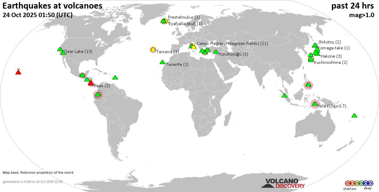
World map showing volcanoes with shallow (less than 50 km) earthquakes within 20 km radius during the past 24 hours on 24 Oct 2025 Number in brackets indicate nr of quakes.

Quakes detected near: Abu (22 quakes between mag 0.1-1.3), Akita-Yake-yama (1 quake mag 1.1), Akuseki-jima (1 quake mag 3.1), Bandai (2 quakes between mag 0.3-1.3), Bardarbunga (6 quakes between mag 0.2-2.0), Barva (1 quake mag 3.0)
Brennisteinsfjöll (4 quakes between mag 0.3-1.0), Campi Flegrei (Phlegrean Fields) (18 quakes between mag 0.1-1.2), Cerro Singüil (1 quake mag 2.0), Clear Lake (25 quakes between mag 0.1-2.0), Coso (1 quake mag 1.5), Cuernos de Negros (1 quake mag 3.0), El Chichón (14 quakes between mag 2.2-3.3), El Hierro (1 quake mag 2.1), Eldey (1 quake mag 1.0), Galeras (1 quake mag 3.0), Gran Canaria (1 quake mag 1.1), Hakone (2 quakes between mag 0.3-1.1), Ibusuku (1 quake mag 2.2), Kaguyak (2 quakes between mag 1.6-1.8), Katla (4 quakes between mag 0.6-1.2), Kilauea (3 quakes between mag 1.5-1.7), Kirishima (2 quakes between mag 0.6-1.4), Kolumbo (4 quakes between mag 1.4-2.0), Komaga-take (1 quake mag 1.0), Koruhüyüğü (1 quake mag 2.0), Kozushima (1 quake mag 1.9), Krísuvík (20 quakes between mag 0.1-1.2), Kuchinoshima (2 quakes between mag 2.1-2.5), Kurikoma (1 quake mag 1.0), Kuwae (1 quake mag 1.7), Laguna Aramuaca

Click this link to continue reading the article on the source website.
RSS Feed Source: Academic Keys

Date and TimeMag
DepthDistanceLocationDetailsMap Feb 23, 04:25 am (GMT +12)

4.3

626 km46 km (29 mi) to the W South of Fiji Islands InfoApr 9, 2024 10:45 pm (GMT +12)

4.9

590 km67 km (41 mi) to the SW South of the Fiji Islands InfoFeb 27, 2024 01:49 am (GMT +12)

4.2

611 km42 km (26 mi) to the W South of the Fiji Islands InfoNov 16, 2023 11:55 am (GMT +12)

5.0

610 km64 km (40 mi) to the SW South of the Fiji Islands InfoApr 19, 2023 12:48 pm (GMT +12)

4.0

591 km61 km (38 mi) to the SWSouth of the Fiji Islands InfoApr 18, 2023 04:31 pm (GMT +12)

6.7

580 km67 km (42 mi) to the SW South Pacific Ocean, 477 km south of Suva, Central, Fiji 1 reportInfoJan 13, 2023 04:28 am (GMT +12)

5.5

598 km26 km (16 mi) to the W South of the Fiji Islands InfoSep 29, 2021 07:41 am (GMT +12)

4.8

588 km64 km (40 mi) to the SW South of Fiji Islands InfoJul 15, 2021 11:54 am (GMT +12)

5.1

623 km89 km (55 mi) to the W South of Fiji Islands InfoJul 15, 2021 11:53 am (GMT +12)

5.3

33 km90 km (56 mi) to the N South Pacific Ocean, 363 km southeast of Suva, Central, Fiji InfoSep 26, 2019 01:03 am (GMT +12)

5.2

10 km58 km (36 mi) to the S near Magnitude 5.2, Near of Nouméa InfoFeb 21, 2016 02:38 am (GMT +12)

4.8

570 km83 km (52 mi) to the SW South Pacific Ocean, 481 km south of Suva, Central, Fiji InfoOct 9, 2014 11:34 pm (GMT +12)

5.0

599 km37 km (23 mi) to the SW South of Fiji Islands

Click this link to continue reading the article on the source website.

RSS Feed Source: Academic Keys

<!–div style="font-size:14px;text-align:center;border:3px solid blue;border-radius:5px;padding:3px;margin:5px;background:#eee"><a href="https://www.volcanoesandearthquakes.com/app/volcano-report.php?volcanoId=44" style="text-decoration:none" target="_blank" rel="noopener noreferrer nofollow" title="Share a volcano (activity) report, submit a photo or other interesting news!” onclick=”window.open(this.href,’Volcano Report’,’status=0,toolbar=0,location=0,directories=0,menubar=0,resizable=1,scrollbars=1,height=500,width=450′);return false”>Send Volcano Report</div–> Stratovolcano 3676 m (12,060 ft)
East Java, Indonesia, -8.11°S / 112.92°E
Current status: erupting (4 out of 5) Semeru volcano eruptions:
1818, 1829, 1830, 1832, 1836, 1838, 1842, 1844, 1845, 1848, 1849(?), 1851, 1856, 1857, 1865, 1866(?), 1887, 1887, 1888, 1889-91, 1892, 1893, 1893-94, 1895, 1896, 1897, 1899, 1899, 1900, 1901, 1903, 1904, 1905, 1907, 1908, 1909-10, 1910-11, 1911, 1912, 1913, 1941-42, 1945, 1946, 1946-47, 1950-64, 1967-ongoing
Typical eruption style
Explosive. Near constant strombolian activity, occasionally stronger explosions, lava flows and pyroclastic flows.

Click this link to continue reading the article on the source website.