RSS feed source: USGS Earthquake Hazards Program
Time2025-08-20 05:55:29 UTC2025-08-20 05:55:29 UTC at epicenterLocation5.506°N 32.935°WDepth10.00 km (6.21 mi)
Click this link to continue reading the article on the source website.
RSS feed source: USGS Earthquake Hazards Program
Time2025-08-20 05:55:29 UTC2025-08-20 05:55:29 UTC at epicenterLocation5.506°N 32.935°WDepth10.00 km (6.21 mi)
Click this link to continue reading the article on the source website.
RSS feed source: USGS Earthquake Hazards Program
Date and TimeMag
DepthDistanceLocationDetailsMap Feb 21, 2024 04:31 am (GMT -2)
4.2
10 km39 km (24 mi) to the NCentral Mid-Atlantic Ridge InfoFeb 12, 2024 02:19 am (GMT -2)
4.5
10 km38 km (24 mi) to the N Central Mid-Atlantic Ridge InfoFeb 12, 2024 02:18 am (GMT -2)
4.6
10 km3.2 km (2 mi) to the WCentral Mid-Atlantic Ridge InfoFeb 12, 2024 02:11 am (GMT -2)
5.4
10 km8.8 km (5.5 mi) to the E Central Mid-Atlantic Ridge InfoFeb 12, 2024 01:53 am (GMT -2)
4.6
10 km29 km (18 mi) to the NWCentral Mid-Atlantic Ridge InfoFeb 12, 2024 01:43 am (GMT -2)
5.2
10 km13 km (8.1 mi) to the NE Central Mid-Atlantic Ridge InfoFeb 10, 2024 03:35 pm (GMT -2)
4.9
10 km0.6 km (0.4 mi) to the E Central Mid-Atlantic Ridge InfoAug 16, 2020 08:24 am (GMT -2)
4.9
10 km77 km (48 mi) to the S Central Mid-Atlantic Ridge 1 reportInfoJul 24, 2019 01:38 pm (GMT -2)
4.9
10 km8.1 km (5 mi) to the NE Central Mid-Atlantic Ridge InfoJan 22, 2018 05:39 pm (GMT -2)
5.0
10 km16 km (9.6 mi) to the NECentral Mid-Atlantic Ridge InfoDec 28, 2017 09:20 am (GMT -2)
4.8
10 km20 km (12 mi) to the NE Central Mid Atlantic Ridge InfoMar 27, 2017 07:26 pm (GMT -2)
5.1
10 km64 km (40 mi) to the N Central Mid-Atlantic Ridge 1 reportInfoFeb 20, 2016 03:48 pm (GMT -2)
4.8
15 km56 km (35 mi) to the SE Central Mid-Atlantic Ridge InfoFeb 20, 2016 02:48 pm (GMT -2)
4.8
10 km68 km (42 mi) to the S Central Mid Atlantic Ridge 1 reportInfoNov 3, 2014 06:27 am (GMT -2)
5.1
10 km77 km (48 mi) to the S Central Mid-Atlantic Ridge InfoNov 3, 2014 04:25 am (GMT -2)
4.8
10 km73 km (45 mi)
Click this link to continue reading the article on the source website.
RSS feed source: USGS Earthquake Hazards Program
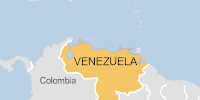
On 17/08/2025, a flood started in Venezuela, lasting until 19/08/2025 (last update). The flood caused 1 deaths and 0 displaced .
Click this link to continue reading the article on the source website.
RSS feed source: USGS Earthquake Hazards Program
Background:
Volcán Popocatépetl, whose name is the Aztec word for smoking mountain, towers to 5426 m 70 km SE of Mexico City to form North America’s 2nd-highest volcano. The glacier-clad stratovolcano contains a steep-walled, 250-450 m deep crater. The generally symmetrical volcano is modified by the sharp-peaked Ventorrillo on the NW, a remnant of an earlier volcano.
At least three previous major cones were destroyed by gravitational failure during the Pleistocene, producing massive debris-avalanche deposits covering broad areas south of the volcano. The modern volcano was constructed to the south of the late-Pleistocene to Holocene El Fraile cone. Three major plinian eruptions, the most recent of which took place about 800 AD, have occurred from Popocatépetl since the mid Holocene, accompanied by pyroclastic flows and voluminous lahars that swept basins below the volcano. Frequent historical eruptions, first recorded in Aztec codices, have occurred since precolumbian
Click this link to continue reading the article on the source website.