RSS feed source: Volcano Discovery.com--Global earthquake monitor

Wednesday, Nov 26, 2025 20:04 | 19 mins ago | By: EarthquakeMonitor

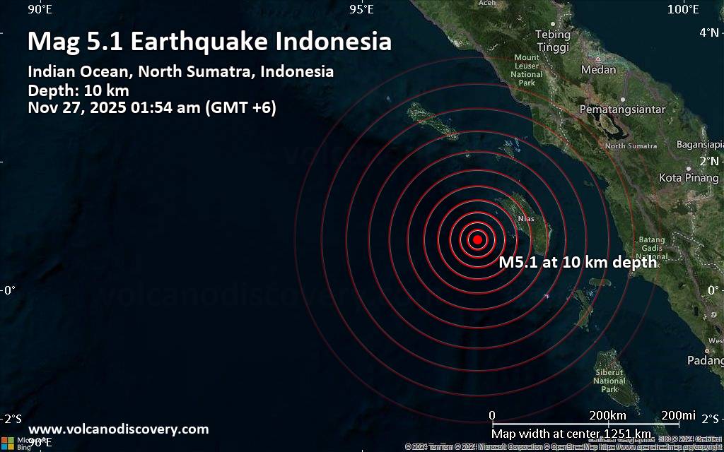
A shallow magnitude 5.1 earthquake was reported early morning near Lahewa, North Nias Regency, North Sumatra, Indonesia.
According to Indonesia’s Meteorology, Climatology, and Geophysical Agency, the quake hit on Thursday, November 27th, 2025, at 1:54 am local time at a shallow depth of 10. km. Shallow earthquakes are felt more strongly than deeper ones as they are closer to the surface. The exact magnitude, epicenter, and depth of the quake might be revised within the next few hours or minutes as seismologists review data and refine their calculations, or as other agencies issue their report.
Based on the preliminary seismic data, the quake should not have caused any significant damage, but was probably felt by many people as light vibration in the area of the epicenter.
Weak shaking might have been felt in Lahewa (pop. 24,500) located 79 km from the epicenter, Gunungsitoli (pop. 136,700) 106 km away, and Teluk Dalam (pop. 25,800) 114 km away.
VolcanoDiscovery will automatically update magnitude and depth if these change and follow up if other significant news about the quake become available. If you’re in the area, please send us your experience through our reporting mechanism, either online or via our mobile app. This will help us provide more first-hand updates to anyone around the globe

Click this link to continue reading the article on the source website.

RSS feed source: Volcano Discovery.com--Global earthquake monitor

Date and TimeMag
DepthDistanceLocationDetailsMap Jul 1, 08:08 pm (Pontianak)

4.6

13 km80 km (50 mi) to the N Indian Ocean, 22 km northwest of Lahewa, Indonesia InfoJul 1, 08:07 pm (Jakarta)

4.4

17 km77 km (48 mi) to the N Indian Ocean, 18 km northwest of Lahewa, Indonesia InfoJul 1, 02:47 pm (Jakarta)

4.0

13 km60 km (37 mi) to the N Indian Ocean, 19 km southwest of Lahewa, Indonesia InfoJun 11, 05:26 pm (GMT +7)

4.1

30 km91 km (57 mi) to the SE Indian Ocean, 81 km southwest of Teluk Dalam, Indonesia InfoJun 11, 05:28 am (Jakarta)

4.1

21 km68 km (43 mi) to the NE Northern Sumatra, Indonesia InfoMay 7, 02:09 pm (Jakarta)

5.2

22 km47 km (29 mi) to the E Indian Ocean, 62 km southwest of Pulau Nias Island, North Sumatra, Indonesia 1 reportInfoJul 20, 2024 06:05 pm (GMT +6)

5.5

30 km69 km (43 mi) to the S Indian Ocean, 146 km southwest of Pulau Nias Island, North Sumatra, Indonesia 1 reportInfoJan 9, 2024 10:45 am (GMT +6)

5.1

10 km88 km (55 mi) to the S Indian Ocean, 165 km southwest of Pulau Nias Island, North Sumatra, Indonesia 1 reportInfoApr 25, 2023 03:00 am (Jakarta)

7.3

84 km261 km (162 mi) to the SE Indian Ocean, 76 km northwest of Pulau Siberut Island, Indonesia 243 reportsInfoSep 8, 2022 02:58 pm (Jakarta)

5.1

10 km66 km (41 mi) to the N Indian Ocean, 79 km northwest of Pulau Nias Island, North Sumatra, Indonesia InfoAug 15, 2022 10:35 pm (GMT +6)

5.5

25 km86 km (53 mi) to the S Indian Ocean, 165 km southwest of Pulau Nias Island, North Sumatra, Indonesia InfoNov

Click this link to continue reading the article on the source website.

RSS feed source: Volcano Discovery.com--Global earthquake monitor

Wednesday, Nov 26, 2025 19:46 | 44 mins ago | By: EarthquakeMonitor

Just 3 minutes ago, a 2.8-magnitude earthquake struck near Lubin, Lubin County, Lower Silesian Voivodeship, Poland. The tremor was recorded in the evening on Wednesday, November 26th, 2025, at 8:42 pm local time, at a very shallow depth of 0. km below the surface.
The event was filed by the European-Mediterranean Seismological Centre (EMSC), the first seismological agency to report it.
Based on the preliminary seismic data, the quake should not have caused any significant damage, but was probably felt by many people as light vibration in the area of the epicenter.
Weak shaking might have been felt in Polkowice (pop. 21,600) located 5 km from the epicenter.
Other towns or cities near the epicenter where the quake might have been felt as very weak shaking include Lubin (pop. 77,500) located 12 km from the epicenter, and Glogow (pop. 65,400) 19 km away. In Legnica (pop. 106,000, 32 km away), Zlotoryja (pop. 15,600, 45 km away), Nowa Sol (pop. 40,400, 45 km away), Leszno (pop. 63,600, 48 km away), Boleslawiec (pop. 40,700, 48 km away), and Zielona Gora (pop. 118,400, 66 km away), the quake was probably not felt.

If you felt it, report it through our site or app right now!

Download and Upgrade the Volcanoes & Earthquakes app to get one of

Click this link to continue reading the article on the source website.

RSS feed source: Volcano Discovery.com--Global earthquake monitor

<!–div style="font-size:14px;text-align:center;border:3px solid blue;border-radius:5px;padding:3px;margin:5px;background:#eee"><a href="https://www.volcanoesandearthquakes.com/app/volcano-report.php?volcanoId=26" style="text-decoration:none" target="_blank" rel="noopener noreferrer nofollow" title="Share a volcano (activity) report, submit a photo or other interesting news!” onclick=”window.open(this.href,’Volcano Report’,’status=0,toolbar=0,location=0,directories=0,menubar=0,resizable=1,scrollbars=1,height=500,width=450′);return false”>Send Volcano Report</div–> Stratovolcano 3,763 m / 12,346 ft
Guatemala, 14.47°N / -90.88°W
Current status: erupting (4 out of 5) Fuego volcano eruptions:
1581, 1585, 1586, 1587, 1614, 1617, 1620, 1623, 1629, 1679(?), 1685, 1686, 1689(?), 1699, 1702, 1705, 1706, 1709(?), 1710,1717,1730, 1732, 1737, 1751(?), 1765(?), 1773(?), 1799, 1826, 1829, 1850(?), 1852(?), 1855, 1856, 1857, 1860, 1861(?), 1867(?), 1880, 1896, 1932, 1944, 1949, 1953, 1955, 1957, 1962, 1963, 1966, 1967, 1971, 1973, 1974, 1975, 1977, 1987, 1999, 2002 – ongoing
Typical eruption style
Dominantly explosive, construction of lava domes and extrusion of viscous lava flows. In near constant activity, at least during the past centuries.

Click this link to continue reading the article on the source website.