RSS feed source: Volcano Discovery.com--Global earthquake monitor

Date and TimeMag
DepthDistanceLocationDetailsMap Nov 16, 06:09 pm (GMT -6)

4.2

31 km424 km (264 mi) to the NW North Pacific Ocean, 77 km south of Retalhuleu, GuatemalaI FELT IT InfoOct 28, 12:55 pm (Guatemala)

4.3

45 km427 km (265 mi) to the NW 74 km southwest of Escuintla, Departamento de Escuintla, Guatemala 2 reportsInfoOct 21, 05:06 pm (Guatemala)

4.7

182 km373 km (232 mi) to the NW Departamento de Escuintla, 30 km south of Guatemala City, Guatemala InfoOct 19, 01:05 am (GMT -6)

4.1

24 km350 km (218 mi) to the NW North Pacific Ocean, 31 km south of Puerto San Jose, Guatemala InfoOct 13, 06:47 pm (Guatemala)

4.2

5 km393 km (244 mi) to the NW Offshore Guatemala 1 reportInfoAug 26, 06:25 am (GMT -6)

5.0

35 km355 km (221 mi) to the W North Pacific Ocean, 115 km south of Masagua, Guatemala InfoAug 23, 03:14 am (GMT -6)

6.0

10 km281 km (175 mi) to the NW North Pacific Ocean, Departamento de San Salvador, 81 km southwest of Acajutla, El Salvador 86 reportsInfoAug 16, 11:59 pm (GMT -6)

5.4

10 km358 km (223 mi) to the W North Pacific Ocean, Departamento de Guatemala, 125 km south of Escuintla, Guatemala 2 reportsInfoJul 29, 03:42 pm (Guatemala)

4.8

10 km309 km (192 mi) to the NW 26 km south of Jutiapa, Departamento de Jutiapa, Guatemala 12 reportsInfoJul 29, 03:25 pm (Guatemala)

5.7

10 km304 km (189 mi) to the NW 26 km south of Jutiapa, Departamento de Jutiapa, Guatemala 37 reportsInfoJan 26, 2024 11:52 pm (Guatemala)

6.1

90 km363 km (225 mi) to the NW Departamento de Santa Rosa, 65 km south of Guatemala City, Guatemala

Click this link to continue reading the article on the source website.
RSS feed source: Volcano Discovery.com--Global earthquake monitor

Wednesday, Nov 19, 2025 21:00 | 1 hour ago | By: several contributors

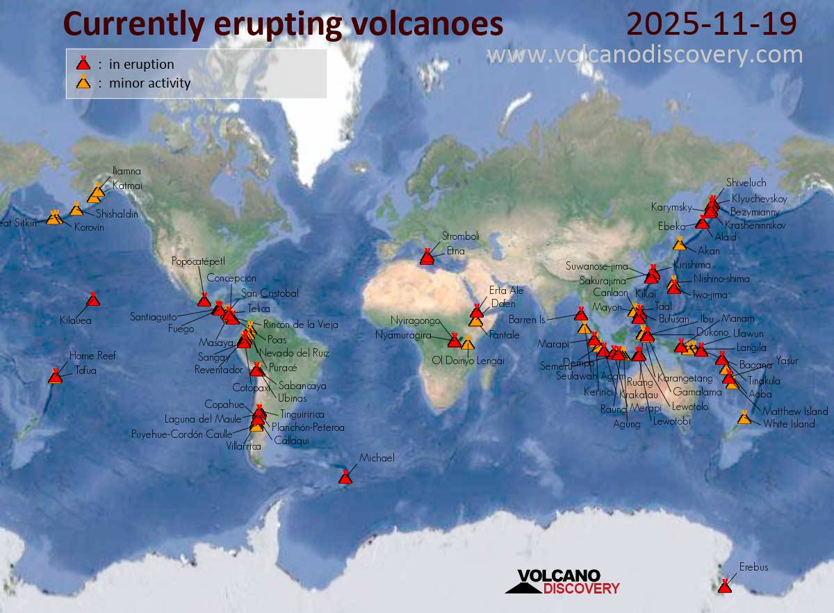
Map of today’s active volcanoes

Stromboli (Eolian Islands, Italy): The Instituto Nazionale di Geofisica e Vulcanologia-Osservatorio Etneo (INGV-Osservatorio Etneo) reported that the eruption continued at Stromboli on 18 November 2025 (local). The alert level remained at “Orange” (level 3 on a 4-level scale). The alert level remained at “Yellow” (level 2 on a 4-level scale).
Source: Instituto Nazionale di Geofisica e Vulcanologia-Osservatorio Etneo (INGV-Osservatorio Etneo)
… [read more]

Krasheninnikov (Kamchatka, Russia): The Kamchatkan Volcanic Eruption Response Team (KVERT) and Laboratory for Seismic and Volcanic Activity Research (ISVA) reported that the eruption continued at Krasheninnikov on 17 November 2025 (local). The aviation alert level remained at “Orange” (level 3 on a 4-level scale).

Source: Kamchatkan Volcanic Eruption Response Team (KVERT); Laboratory for Seismic and Volcanic Activity Research (ISVA)
… [read more]

Shiveluch (Kamchatka): The Kamchatkan Volcanic

Click this link to continue reading the article on the source website.

RSS feed source: Volcano Discovery.com--Global earthquake monitor

Date and TimeMag
DepthDistanceLocationDetailsMap Sep 24, 02:08 am (GMT +9)

4.6

155 km79 km (49 mi) to the N East China Sea, 87 km northwest of Naze, Kagoshima-ken, Japan InfoSep 4, 05:31 am (GMT +9)

4.6

21 km86 km (53 mi) to the SE Philippine Sea, 53 km southeast of Isen, Kagoshima-ken, Japan InfoAug 16, 08:28 am (GMT +9)

4.4

46 km100 km (62 mi) to the SW East China Sea, 26 km west of China, Kagoshima-ken, Japan InfoAug 9, 03:41 pm (GMT +9)

4.1

4.5 km85 km (53 mi) to the W East China Sea, 98 km west of Tokuno Shima Island, Kagoshima-ken, Japan InfoAug 7, 10:26 pm (GMT +9)

4.0

2.6 km83 km (52 mi) to the W East China Sea, 95 km west of Tokuno Shima Island, Kagoshima-ken, Japan InfoAug 6, 09:56 am (GMT +9)

5.0

10 km69 km (43 mi) to the W East China Sea, 72 km west of Amagi, Kagoshima-ken, Japan InfoAug 5, 08:39 am (GMT +9)

4.6

10 km89 km (55 mi) to the W East China Sea, 75 km northwest of Okinoerabujima Island, Kagoshima-ken, Japan InfoDec 13, 2022 11:25 pm (GMT +9)

5.6

19 km89 km (55 mi) to the SE Philippine Sea, 66 km southeast of Tokuno Shima Island, Kagoshima-ken, Japan 3 reportsInfoFeb 10, 2019 02:34 pm (GMT +9)

5.0

35 km66 km (41 mi) to the E Ryukyu Islands, Japan InfoJul 13, 2017 09:35 pm (GMT +9)

5.2

48 km43 km (27 mi) to the E East China Sea, 15 km southeast of Kakeroma Jima Island, Kagoshima-ken, Japan InfoApr 20, 2017 12:16 am (GMT +9)

5.0

10 km97 km (60 mi) to the SE Philippine Sea, 112 km

Click this link to continue reading the article on the source website.