RSS feed source: USGS Earthquake Hazards Program
Time2025-11-07 17:31:58 UTC2025-11-07 17:31:58 UTC at epicenterLocation17.885°S 178.314°WDepth534.59 km (332.18 mi)
Click this link to continue reading the article on the source website.
RSS feed source: USGS Earthquake Hazards Program
Time2025-11-07 17:31:58 UTC2025-11-07 17:31:58 UTC at epicenterLocation17.885°S 178.314°WDepth534.59 km (332.18 mi)
Click this link to continue reading the article on the source website.
RSS feed source: USGS Earthquake Hazards Program
Fri, 7 Nov 2025, 16:50 | BY: EARTHQUAKEMONITOR
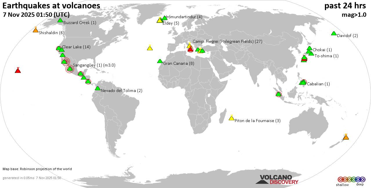
World map showing volcanoes with shallow (less than 50 km) earthquakes within 20 km radius during the past 24 hours on 7 Nov 2025 Number in brackets indicate nr of quakes.
Quakes detected near: Apaneca Range (3 quakes between mag 2.0-2.2), Askja (3 quakes between mag 0.7-1.1), Buzzard Creek (1 quake mag 1.9), Campi Flegrei (Phlegrean Fields) (41 quakes between mag 0.1-2.2), Clear Lake (16 quakes between mag 0.7-1.7), Coso (1 quake mag 1.2)
Cuernos de Negros (1 quake mag 3.0), El Chichón (25 quakes between mag 2.0-2.9), El Hierro (1 quake mag 1.6), Eldey (6 quakes between mag 0.7-2.4), Esjufjöll (1 quake mag 1.1), Etna (3 quakes between mag 1.2-1.4), Gran Canaria (5 quakes between mag 0.9-1.1), Hulubelu (1 quake mag 2.1), Ibusuku (1 quake mag 1.0), Isla Tortuga (1 quake mag 4.4), Kilauea (1 quake mag 1.8), Kolumbo (2 quakes between mag 0.9-1.3), Krísuvík (4 quakes between mag 0.2-1.2), Ljósufjöll (10 quakes between mag 0.1-1.8), Maroa (1 quake mag 1.6), Maunaloa (1 quake mag 1.7), Midagahara (3 quakes between mag 0.2-1.5), Nantai (2 quakes between mag 2.5-2.6), Naolinco (1 quake mag 3.3), Natib (1 quake mag 2.1), Ontake-san (3 quakes between mag 0.4-1.9), Oshima (1 quake mag 2.1), Prestahnukur (3 quakes between mag 1.3-1.4), Salton Buttes (5 quakes between mag 1.2-1.4), Sangangüey (1 quake
Click this link to continue reading the article on the source website.
RSS feed source: USGS Earthquake Hazards Program
Date and TimeMag
DepthDistanceLocationDetailsMap Nov 4, 08:20 am (GMT +13)
4.6
543 km12 km (7.3 mi) to the SW South of the Fiji Islands I FELT IT InfoOct 29, 03:46 pm (GMT +13)
4.6
574 km34 km (21 mi) to the NE South of the Fiji Islands InfoOct 28, 11:46 pm (GMT +12)
4.3
527 km86 km (54 mi) to the S South of the Fiji Islands InfoOct 3, 06:22 am (GMT +12)
4.3
531 km80 km (50 mi) to the S South of the Fiji Islands InfoOct 1, 02:56 am (GMT +13)
4.3
600 km117 km (73 mi) to the SE New Zealand InfoOct 7, 2024 03:02 pm (GMT +13)
5.7
566 km87 km (54 mi) to the E Fiji: New Zealand InfoJun 16, 2023 07:06 am (GMT +13)
7.2
179 km288 km (179 mi) to the E South Pacific Ocean, 285 km southwest of Nuku’alofa, Tongatapu, Tonga 11 reportsInfoJul 28, 2022 04:16 am (GMT +12)
5.7
535 km22 km (14 mi) to the E South of the Fiji Islands InfoFeb 25, 2017 06:28 am (GMT +13)
6.8
419 km100 km (62 mi) to the E South of Fiji Islands 1 reportInfoOct 19, 2016 05:36 am (GMT +13)
5.8
534 km14 km (8.5 mi) to the NW South of Fiji Islands InfoOct 1, 2016 04:25 pm (GMT +12)
5.8
523 km21 km (13 mi) to the SW South of Fiji Islands InfoMay 24, 2013 06:19 am (GMT +13)
7.4
174 km275 km (171 mi) to the E 292 km SW of Vaini, Tonga 1 reportInfoSep 16, 2011 07:31 am (GMT +12)
7.3
645 km207 km (129 mi) to the N South Pacific Ocean, 386 km south of Lakeba Island, Eastern, Fiji InfoDec 28, 2010 09:34 pm (GMT
Click this link to continue reading the article on the source website.
RSS feed source: USGS Earthquake Hazards Program
Date and TimeMag
DepthDistanceLocationDetailsMap Nov 7, 05:02 pm (Fiji)
4.4
610 km26 km (16 mi) to the S 244 km E of Levuka, Fiji I FELT IT InfoOct 19, 01:09 pm (Fiji)
4.2
509 km16 km (10 mi) to the W 235 km E of Levuka, Fiji InfoOct 17, 06:43 am (Fiji)
4.3
568 km10.8 km (6.7 mi) to the SE 259 km E of Levuka, Fiji InfoOct 10, 10:49 pm (Fiji)
4.4
577 km51 km (31 mi) to the NW 214 km ENE of Levuka, Fiji InfoOct 7, 09:36 am (Fiji)
4.3
589 km22 km (14 mi) to the SW 233 km E of Levuka, Fiji InfoOct 5, 06:50 am (GMT +12)
4.9
532 km92 km (57 mi) to the SE 295 km ESE of Levuka, Fiji InfoSep 21, 01:50 am (Fiji)
4.5
594 km10.8 km (6.7 mi) to the S 252 km E of Levuka, Fiji InfoSep 16, 08:29 am (GMT +12)
4.9
640 km54 km (34 mi) to the E Fiji Region InfoSep 7, 06:51 am (Fiji)
4.6
550 km15 km (9.4 mi) to the E 266 km E of Levuka, Fiji InfoSep 5, 04:01 pm (Fiji)
4.5
551 km66 km (41 mi) to the NW 208 km ENE of Levuka, Fiji InfoOct 31, 2023 11:10 pm (Fiji)
6.5
560 km85 km (53 mi) to the NW 185 km ENE of Levuka, Fiji 1 reportInfoNov 12, 2022 07:09 pm (GMT +12)
7.0
579 km248 km (154 mi) to the S South Pacific Ocean, 217 km south of Lakeba Island, Eastern, Fiji 3 reportsInfoMar 10, 2019 08:12 pm (Fiji)
6.2
562 km38 km (24 mi) to the W South Pacific Ocean, 309 km east of Suva, Central, Fiji InfoNov 19, 2018 09:25 am (Fiji)
6.7
536 km61 km (38 mi) to
Click this link to continue reading the article on the source website.