RSS feed source: USGS Earthquake Hazards Program

Sunday, Nov 9, 2025 23:50 | 1 hour ago | By: EarthquakeMonitor

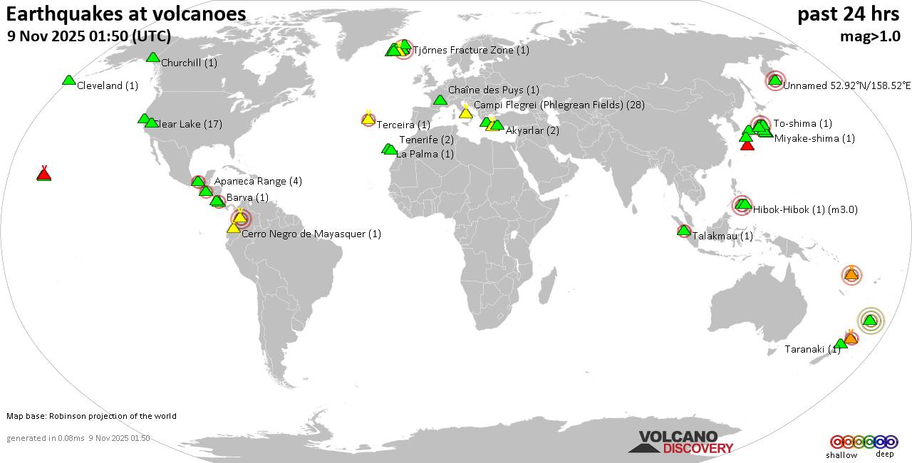
World map showing volcanoes with shallow (less than 50 km) earthquakes within 20 km radius during the past 24 hours on 9 Nov 2025 Number in brackets indicate nr of quakes.

Quakes detected near: Akuseki-jima (1 quake mag 2.3), Askja (3 quakes between mag 0.4-3.5), Aso (1 quake mag 1.0), Barva (2 quakes between mag 1.5-1.7), Batu Tara (1 quake mag 3.5), Campi Flegrei (Phlegrean Fields) (45 quakes between mag 0.1-2.5)
Canlaon (4 quakes between mag 2.7-3.0), Cerro Negro de Mayasquer (4 quakes between mag 1.9-3.5), Chiginagak (2 quakes between mag 2.1-2.3), Ciremai (1 quake mag 2.5), Clear Lake (11 quakes between mag 0.4-1.8), Cuernos de Negros (1 quake mag 3.0), Daisen (2 quakes between mag 0.5-2.1), El Chichón (6 quakes between mag 2.2-2.4), Eldey (2 quakes between mag 1.3-1.7), Grímsnes (1 quake mag 1.5), Hekla (3 quakes between mag 0.8-2.3), Kilauea (3 quakes between mag 1.8-1.9), Kolumbo (5 quakes between mag 1.0-1.6), Krísuvík (5 quakes between mag 0.1-1.4), Kurikoma (2 quakes between mag 0.6-1.0), Lavic Lake (1 quake mag 1.0), Loihi (1 quake mag 1.8), Masaya (1 quake mag 2.7), Nii-jima (1 quake mag 1.7), Salton Buttes (5 quakes between mag 1.1-1.9), Sanbe (5 quakes between mag 0.2-1.9), Santa Clara (1 quake mag 3.0), Santorini (2 quakes between mag 0.8-1.3), Socompa

Click this link to continue reading the article on the source website.
RSS feed source: USGS Earthquake Hazards Program

Date and TimeMag
DepthDistanceLocationDetailsMap May 27, 09:03 pm (Salta)

4.2

143 km95 km (59 mi) to the NE 182 km NNW of Antofagasta De La Sierra, Argentina InfoApr 16, 05:45 am (Santiago)

4.1

99 km60 km (37 mi) to the NE 217 km southeast of Antofagasta, Provincia de Antofagasta, Region de Antofagasta, Chile InfoMar 4, 09:21 pm (Santiago)

4.5

98 km64 km (40 mi) to the N 166 km southeast of Antofagasta, Provincia de Antofagasta, Region de Antofagasta, Chile InfoJan 15, 11:06 am (Santiago)

4.1

101 km51 km (32 mi) to the NW 52 km al SO de Mina La Escondida InfoJan 7, 12:47 pm (Santiago)

4.1

130 km97 km (60 mi) to the SW 69 km E of Taltal, Chile InfoNov 10, 2024 01:23 pm (Santiago)

4.3

106 km88 km (55 mi) to the NW 133 km SE of Antofagasta, Chile InfoJul 18, 2024 09:50 pm (Santiago)

7.4

145 km234 km (145 mi) to the N 115 km southeast of Calama, Provincia de El Loa, Region de Antofagasta, Chile 170 reportsInfoMay 9, 2024 08:29 am (Santiago)

4.3

88 km88 km (54 mi) to the NW 121 km NE of Taltal, Chile InfoApr 3, 2024 08:28 pm (Santiago)

4.8

73 km89 km (55 mi) to the NW 126 km SE of Antofagasta, Chile 10 reportsInfoMar 30, 2024 12:54 am (Salta)

4.5

95 km74 km (46 mi) to the E 286 km west of Salta, Departamento Capital, Salta Province, Argentina 4 reportsInfoMar 26, 2023 07:39 am (Santiago)

5.1

8.4 km74 km (46 mi) to the S Provincia de Antofagasta, Region de Antofagasta, 116 km northeast of Diego de Almagro, Chanaral, Region de Atacama, Chile 4 reportsInfoDec 5, 2021 05:51

Click this link to continue reading the article on the source website.

RSS feed source: USGS Earthquake Hazards Program

Date and TimeMag
DepthDistanceLocationDetailsMap Aug 14, 04:49 pm (GMT -5)

4.2

28 km79 km (49 mi) to the N South Pacific Ocean, 152 km west of Chiclayo, Lambayeque, Peru InfoJan 8, 03:00 pm (Lima)

4.5

10 km90 km (56 mi) to the NW 113 km SSW of Sechura, Peru InfoDec 29, 2024 07:35 pm (Lima)

4.1

34 km48 km (30 mi) to the NE Near Coast of Northern Peru InfoFeb 6, 2024 08:08 pm (GMT -5)

4.0

38 km97 km (60 mi) to the SE Off Coast of Northern Peru InfoDec 18, 2023 12:05 pm (Lima)

4.0

25 km83 km (52 mi) to the N Near Coast of Northern Peru InfoDec 16, 2022 05:23 am (GMT -5)

5.2

10 km52 km (32 mi) to the E 68 km WSW of Pimentel, Peru 1 reportInfoJul 6, 2015 06:17 am (Lima)

5.0

25 km33 km (21 mi) to the NE Off Coast of Northern Peru 1 reportInfoJun 7, 2015 01:39 am (Lima)

5.0

10 km76 km (47 mi) to the NW Near Coast of Northern Peru 1 reportInfoAug 3, 2014 10:20 pm (GMT -5)

5.2

11 km82 km (51 mi) to the NW Near Coast of Northern Peru 1 reportInfoNov 29, 2012 02:09 am (GMT -5)

5.5

10 km73 km (45 mi) to the N 117 km W of Mórrope, Peru InfoFeb 9, 2009 09:09 am (GMT -5)

6.0

15 km77 km (48 mi) to the N 117 km SSW of Sechura, Peru InfoFeb 8, 2009 04:23 pm (GMT -5)

5.1

76 km53 km (33 mi) to the N 100 km WSW of Mórrope, Peru InfoFeb 25, 2007 07:19 pm (GMT -5)

5.3

35 km37 km (23 mi) to the E 83 km WSW of Pimentel, Peru InfoFeb 23, 2007

Click this link to continue reading the article on the source website.