RSS feed source: Volcano Discovery.com--Global earthquake monitor

Date and TimeMag
DepthDistanceLocationDetailsMap Sep 2, 01:01 pm (Makassar)

4.1

65 km26 km (16 mi) to the SE 168 km northeast of Palu, Kota Palu, Sulawesi Tengah, Indonesia InfoJul 27, 11:21 am (Makassar)

4.3

58 km82 km (51 mi) to the E 203 km northeast of Palu, Kota Palu, Sulawesi Tengah, Indonesia InfoApr 25, 02:09 pm (Makassar)

4.5

10 km16 km (9.9 mi) to the NE Kabupaten Parigi Moutong, 187 km northeast of Palu, Indonesia InfoMar 22, 11:46 am (Makassar)

4.1

5 km74 km (46 mi) to the NW Makassar Strait, 32 km west of Pulau Simatang Island, Sulawesi Tengah, Indonesia InfoMar 14, 07:13 pm (Makassar)

5.4

21 km73 km (45 mi) to the N Makassar Strait, 19 km northwest of Pulau Simatang Island, Indonesia InfoJan 28, 10:53 pm (Makassar)

5.8

76 km86 km (53 mi) to the E Kabupaten Parigi Moutong, 219 km northeast of Palu, Indonesia 16 reportsInfoOct 20, 2024 01:24 pm (Makassar)

4.8

88 km71 km (44 mi) to the E 187 km northeast of Palu, Kota Palu, Sulawesi Tengah, Indonesia InfoOct 20, 2024 02:07 am (Makassar)

5.5

35 km67 km (41 mi) to the W Makassar Strait, 81 km southwest of Pulau Simatang Island, Indonesia InfoSep 9, 2023 10:43 pm (Makassar)

6.3

10 km92 km (57 mi) to the SW Makassar Strait, 105 km north of Palu, Kota Palu, Sulawesi Tengah, Indonesia 5 reportsInfoMar 25, 2021 05:23 am (Makassar)

5.2

576 km77 km (48 mi) to the NE Kabupaten Toli-Toli, 248 km northeast of Palu, Indonesia InfoOct 9, 2018 05:15 am (Makassar)

5.1

10 km81 km (50 mi) to the SW Kabupaten Parigi Moutong, 100 km north of Palu, Indonesia 2 reportsInfoSep 28, 2018

Click this link to continue reading the article on the source website.

RSS feed source: Volcano Discovery.com--Global earthquake monitor

Wednesday, Nov 19, 2025 23:50 | 2 hours ago | By: EarthquakeMonitor

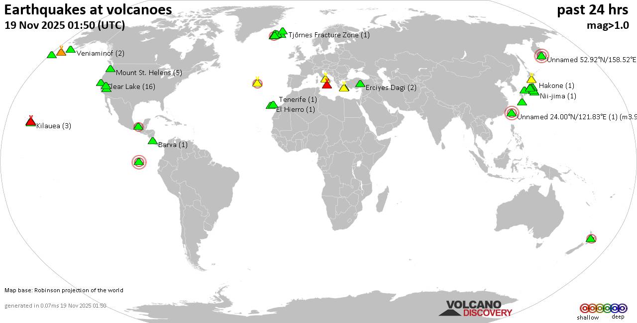
World map showing volcanoes with shallow (less than 50 km) earthquakes within 20 km radius during the past 24 hours on 19 Nov 2025 Number in brackets indicate nr of quakes.

Quakes detected near: Akita-Yake-yama (8 quakes between mag 0.2-1.1), Askja (3 quakes between mag 0.8-1.7), Baluran (1 quake mag 2.7), Baru (1 quake mag 3.3), Campi Flegrei (Phlegrean Fields) (46 quakes between mag 0.1-2.7), Clear Lake (39 quakes between mag 0.2-2.3)
Cofre de Perote (3 quakes between mag 2.6-3.2), El Chichón (2 quakes between mag 2.3-2.4), El Hierro (1 quake mag 1.2), Eldey (122 quakes between mag 0.2-2.8), Etna (1 quake mag 1.6), Irazu (1 quake mag 2.1), Katla (4 quakes between mag 0.3-1.2), Kawah Kamojang (1 quake mag 1.8), Kilauea (1 quake mag 1.9), Kirishima (4 quakes between mag 0.3-1.1), Koruhüyüğü (1 quake mag 1.8), Kukak (1 quake mag 1.9), Kurikoma (5 quakes between mag 0.5-1.4), Ljósufjöll (5 quakes between mag 0.4-1.9), Martin (1 quake mag 1.3), Maunaloa (2 quakes between mag 1.0-1.8), Papandayan (7 quakes between mag 1.9-3.3), Prestahnukur (1 quake mag 1.2), Pular (1 quake mag 3.0), Salton Buttes (1 quake mag 1.1), Santorini (1 quake mag 1.6), Tenorio (1 quake mag 1.6), To-shima (2 quakes between mag 1.2-1.9), Yellowstone (1 quake mag 1.3) (updated 23h50)

Note:

Click this link to continue reading the article on the source website.
RSS feed source: Volcano Discovery.com--Global earthquake monitor

Date and TimeMag
DepthDistanceLocationDetailsMap Nov 16, 06:00 pm (GMT -6)

4.2

73 km60 km (38 mi) to the SE 15 km west of Tapachula, Estado de Chiapas, MexicoI FELT IT InfoNov 14, 08:37 am (GMT -6)

4.3

97 km29 km (18 mi) to the NW North Pacific Ocean, 27 km southwest of Mapastepec, Estado de Chiapas, MexicoI FELT IT InfoNov 14, 03:03 am (GMT -6)

4.0

76 km87 km (54 mi) to the NW North Pacific Ocean, 41 km west of Pijijiapan, Estado de Chiapas, MexicoI FELT IT InfoNov 13, 06:06 am (GMT -6)

4.0

70 km38 km (23 mi) to the S North Pacific Ocean, 63 km west of Tapachula, Estado de Chiapas, MexicoI FELT IT InfoNov 8, 10:26 pm (GMT -6)

4.3

51 km77 km (48 mi) to the S North Pacific Ocean, 94 km southwest of Tapachula, Estado de Chiapas, Mexico 1 reportInfoDec 13, 2021 01:03 am (Mexico City)

5.6

180 km77 km (48 mi) to the NE 4.8 km north of Motozintla, Estado de Chiapas, Mexico 72 reportsInfoOct 11, 2020 10:14 pm (GMT -6)

5.5

10 km95 km (59 mi) to the SW North Pacific Ocean, 144 km west of Tapachula, Estado de Chiapas, Mexico 1 reportInfoMar 26, 2020 05:46 pm (GMT -6)

5.5

29 km47 km (29 mi) to the SW North Pacific Ocean, 73 km southwest of Mapastepec, Estado de Chiapas, Mexico 4 reportsInfoMar 14, 2020 07:22 pm (GMT -6)

5.5

31 km23 km (14 mi) to the S North Pacific Ocean, 29 km southwest of La Palma, Estado de Chiapas, Mexico 5 reportsInfoMar 6, 2020 02:30 pm

Click this link to continue reading the article on the source website.