RSS feed source: Volcano Discovery.com--Global earthquake monitor

Fri, 24 Oct 2025, 03:22 | BY: EARTHQUAKEMONITOR

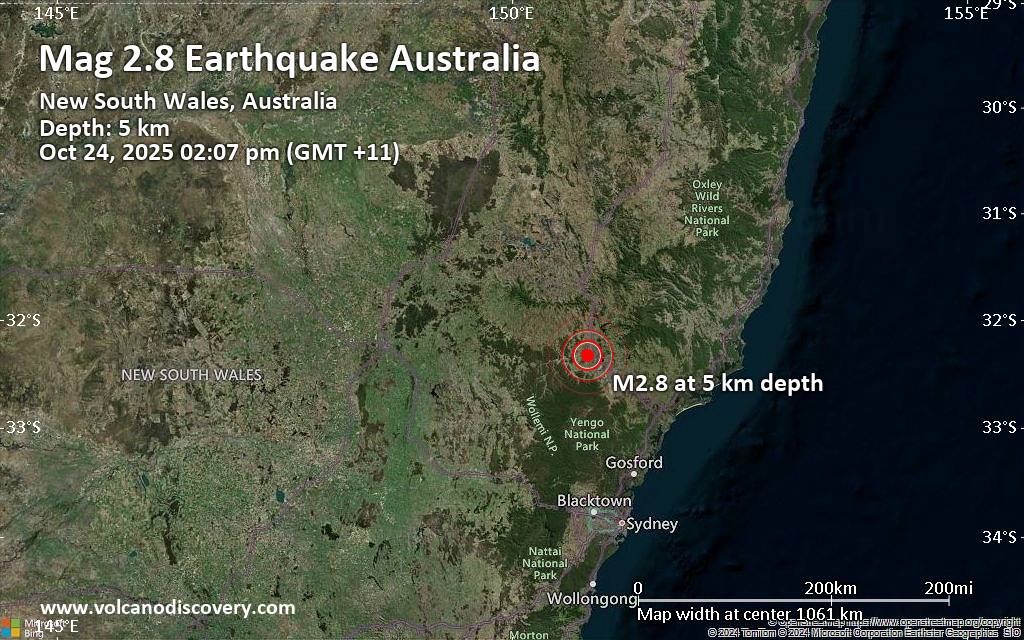
A very shallow magnitude 2.8 earthquake was reported early afternoon near Muswellbrook, New South Wales, Australia.
According to the European-Mediterranean Seismological Centre (EMSC), the quake hit on Friday, October 24th, 2025, at 2:07 pm local time at a very shallow depth of 3.1 miles. Shallow earthquakes are felt more strongly than deeper ones as they are closer to the surface. The exact magnitude, epicenter, and depth of the quake might be revised within the next few hours or minutes as seismologists review data and refine their calculations, or as other agencies issue their report.
Towns or cities near the epicenter where the quake might have been felt as very weak shaking include Muswellbrook (pop. 12,100) located 6 miles from the epicenter, Denman (pop. 1,800) 9 miles away, and Aberdeen (pop. 2,000) 12 miles away. In Scone (pop. 5,600, 19 miles away), Singleton Heights (pop. 4,600, 24 miles away), and Singleton (pop. 5,100, 26 miles away), the quake was probably not felt.

If you felt it, report it through our site or app right now!

Download and Upgrade the Volcanoes & Earthquakes app to get one of the fastest seismic alerts online:
Android | IOS
Earthquake data:

I felt this quake

Date & time: Oct 24, 2025 02:07 pm (GMT +11) local time (24 Oct 2025 03:07 GMT)
Magnitude: 2.7
Depth: 5.00 km
Epicenter latitude /

Click this link to continue reading the article on the source website.

RSS feed source: Volcano Discovery.com--Global earthquake monitor

Date and TimeMag
DepthDistanceLocationDetailsMap Oct 21, 07:10 pm (GMT -7)

4.2

12 km73 km (45 mi) to the SE 65 km southwest of Guaymas, Estado de Sonora, MexicoI FELT IT3 reportsInfoAug 31, 05:53 am (GMT -7)

4.2

5 km11 km (7.1 mi) to the SE Gulf of California InfoAug 30, 01:38 pm (GMT -7)

4.2

5 km7.5 km (4.7 mi) to the W 69 km north of Santa Rosalia, Estado de Baja California Sur, Mexico InfoAug 5, 11:20 pm (GMT -7)

4.2

10 km66 km (41 mi) to the SE 63 km southwest of Guaymas, Estado de Sonora, Mexico 3 reportsInfoJun 30, 11:17 pm (GMT -7)

4.2

12 km39 km (24 mi) to the NW Gulf of California InfoNov 4, 2022 03:02 am (Hermosillo)

6.3

10 km51 km (32 mi) to the NW 170 km southwest of Hermosillo, Estado de Sonora, Mexico 209 reportsInfoJul 31, 2021 08:39 am (GMT -7)

5.5

5 km56 km (35 mi) to the SE Mexico: 63 Km Al SUROESTE De H GUAYMAS, SON 53 reportsInfoAug 10, 2014 11:46 am (GMT -7)

4.9

10 km45 km (28 mi) to the SE Gulf of California 1 reportInfoApr 12, 2012 12:15 am (Tijuana)

7.0

13 km145 km (90 mi) to the NW 70 km northeast of San Luis, Estado de Baja California, Mexico InfoSep 10, 2011 03:07 pm (GMT -7)

4.9

10 km30 km (18 mi) to the NW Gulf of California (Mexico) InfoMay 24, 2011 12:01 pm (GMT -7)

5.1

10 km51 km (31 mi) to the SE 65 km SW of San Carlos, Mexico InfoApr 26, 2011 02:10 pm (GMT -7)

5.3

11 km63 km (39 mi) to the SE 73 km SW of San Carlos,

Click this link to continue reading the article on the source website.

RSS feed source: Volcano Discovery.com--Global earthquake monitor

Fri, 24 Oct 2025, 03:04 | BY: EARTHQUAKEMONITOR

An earthquake of magnitude 4.5 occurred only 8 minutes ago 99 km southeast of Pondaguitan, Philippines, Indonesia’s Meteorology, Climatology, and Geophysical Agency reported.
The quake hit at a moderately shallow depth of 33. km beneath the epicenter near Pondaguitan, Davao Oriental, Davao, Philippines, in the morning on Friday, October 24th, 2025, at 10:55 am local time. The exact magnitude, epicenter, and depth of the quake might be revised within the next few hours or minutes as seismologists review data and refine their calculations, or as other agencies issue their report.
A second report was later issued by the citizen-seismograph network of RaspberryShake, which listed it as a magnitude 4.5 earthquake as well.
Towns or cities near the epicenter where the quake might have been felt as very weak shaking include Pondaguitan (pop. 2,100) located 99 km from the epicenter.
VolcanoDiscovery will automatically update magnitude and depth if these change and follow up if other significant news about the quake become available. If you’re in the area, please send us your experience through our reporting mechanism, either online or via our mobile app. This will help us provide more first-hand updates to anyone around the globe who wants to know more about this quake.

If you felt it, report it through our site or app right now!

Download and Upgrade the

Click this link to continue reading the article on the source website.

RSS feed source: Volcano Discovery.com--Global earthquake monitor

Date and TimeMag
DepthDistanceLocationDetailsMap Oct 24, 06:14 am (GMT +8)

4.7

38 km23 km (15 mi) to the E Philippine Sea, 156 km southeast of Mati, PhilippinesI FELT IT InfoOct 20, 11:47 pm (GMT +8)

4.2

10 km85 km (53 mi) to the N Philippine Sea, 62 km southeast of Mati, PhilippinesI FELT IT InfoOct 19, 03:28 pm (GMT +8)

5.0

191 km67 km (41 mi) to the N Philippine Sea, 80 km southeast of Mati, PhilippinesI FELT IT5 reportsInfoOct 18, 01:26 pm (GMT +8)

4.8

78 km88 km (55 mi) to the N Philippine Sea, 76 km southeast of Mati, PhilippinesI FELT IT InfoOct 14, 06:13 pm (GMT +8)

4.5

142 km14 km (8.5 mi) to the S Philippine Sea, 153 km southeast of Mati, Philippines 1 reportInfoOct 11, 06:35 am (GMT +8)

4.7

10 km54 km (34 mi) to the N Philippine Islands Region 1 reportInfoOct 10, 09:43 am (Manila)

7.4

58 km153 km (95 mi) to the N Philippine Sea, 24 km east of Manay, Philippines 451 reportsInfoDec 2, 2023 10:37 pm (Manila)

7.6

40 km298 km (185 mi) to the N Philippine Sea, 36 km north of Bislig, Philippines 565 reportsInfoAug 11, 2021 05:46 pm (GMT +0)

7.0

63 km72 km (45 mi) to the N Mindanao, Philippines 617 reportsInfoSep 29, 2019 10:02 am (Manila)

6.1

68 km50 km (31 mi) to the SW Philippine Sea, 83 km southeast of Pondaguitan, Philippines 94 reportsInfoDec 29, 2018 11:39 am (GMT +8)

6.8

69 km33 km (21 mi) to the W Philippine Sea, 127 km south of Mati, Philippines 355 reportsInfoSep 24, 2016 06:53 am (Manila)

6.2

54 km92 km (57 mi) to the NW

Click this link to continue reading the article on the source website.