RSS feed source: Volcano Discovery.com--Global earthquake monitor

Date and TimeMag
DepthDistanceLocationDetailsMap Sep 24, 02:08 am (GMT +9)

4.6

155 km79 km (49 mi) to the N East China Sea, 87 km northwest of Naze, Kagoshima-ken, Japan InfoSep 4, 05:31 am (GMT +9)

4.6

21 km86 km (53 mi) to the SE Philippine Sea, 53 km southeast of Isen, Kagoshima-ken, Japan InfoAug 16, 08:28 am (GMT +9)

4.4

46 km100 km (62 mi) to the SW East China Sea, 26 km west of China, Kagoshima-ken, Japan InfoAug 9, 03:41 pm (GMT +9)

4.1

4.5 km85 km (53 mi) to the W East China Sea, 98 km west of Tokuno Shima Island, Kagoshima-ken, Japan InfoAug 7, 10:26 pm (GMT +9)

4.0

2.6 km83 km (52 mi) to the W East China Sea, 95 km west of Tokuno Shima Island, Kagoshima-ken, Japan InfoAug 6, 09:56 am (GMT +9)

5.0

10 km69 km (43 mi) to the W East China Sea, 72 km west of Amagi, Kagoshima-ken, Japan InfoAug 5, 08:39 am (GMT +9)

4.6

10 km89 km (55 mi) to the W East China Sea, 75 km northwest of Okinoerabujima Island, Kagoshima-ken, Japan InfoDec 13, 2022 11:25 pm (GMT +9)

5.6

19 km89 km (55 mi) to the SE Philippine Sea, 66 km southeast of Tokuno Shima Island, Kagoshima-ken, Japan 3 reportsInfoFeb 10, 2019 02:34 pm (GMT +9)

5.0

35 km66 km (41 mi) to the E Ryukyu Islands, Japan InfoJul 13, 2017 09:35 pm (GMT +9)

5.2

48 km43 km (27 mi) to the E East China Sea, 15 km southeast of Kakeroma Jima Island, Kagoshima-ken, Japan InfoApr 20, 2017 12:16 am (GMT +9)

5.0

10 km97 km (60 mi) to the SE Philippine Sea, 112 km

Click this link to continue reading the article on the source website.

RSS feed source: Volcano Discovery.com--Global earthquake monitor

Date and TimeMag
DepthDistanceLocationDetailsMap Oct 27, 09:08 am (GMT +8)

4.7

49 km99 km (61 mi) to the W Philippine Sea, 35 km east of Tandag, Philippines 2 reportsInfoOct 19, 11:05 pm (GMT +8)

4.5

52 km67 km (41 mi) to the W Philippine Sea, 66 km east of Tandag, Philippines 3 reportsInfoOct 18, 08:31 pm (GMT +8)

5.4

63 km98 km (61 mi) to the W Philippine Sea, 38 km southeast of Tandag, Philippines 53 reportsInfoOct 12, 05:44 pm (GMT +8)

4.4

26 km61 km (38 mi) to the SW Philippine Sea, 116 km southeast of Tandag, Philippines 2 reportsInfoOct 12, 02:56 pm (GMT +8)

4.7

54 km56 km (35 mi) to the SW Philippine Sea, Davao, 82 km east of Bislig, Philippines 1 reportInfoOct 10, 09:43 am (Manila)

7.4

58 km176 km (109 mi) to the S Philippine Sea, 24 km east of Manay, Philippines 451 reportsInfoMar 13, 12:09 am (GMT +9)

5.7

10 km47 km (29 mi) to the SE Philippine Sea, 142 km east of Bislig, Philippines 4 reportsInfoAug 3, 2024 12:20 pm (GMT +8)

6.3

15 km81 km (51 mi) to the SW Philippine Sea, 57 km east of Bislig, Philippines 22 reportsInfoDec 5, 2023 09:36 pm (GMT +8)

5.8

12 km78 km (49 mi) to the NW Philippine Sea, 65 km east of Tandag, Philippines 5 reportsInfoDec 5, 2023 05:10 pm (GMT +8)

5.7

20 km84 km (52 mi) to the NW Philippine Sea, 53 km east of Tandag, Philippines 6 reportsInfoDec 4, 2023 03:49 am (GMT +8)

6.9

20 km85 km (53 mi) to the W Philippine Sea, 47 km east of Tandag, Philippines 97 reportsInfoDec 3, 2023 10:35 pm (GMT

Click this link to continue reading the article on the source website.
RSS feed source: Volcano Discovery.com--Global earthquake monitor

Wednesday, Nov 19, 2025 19:50 | 42 mins ago | By: EarthquakeMonitor

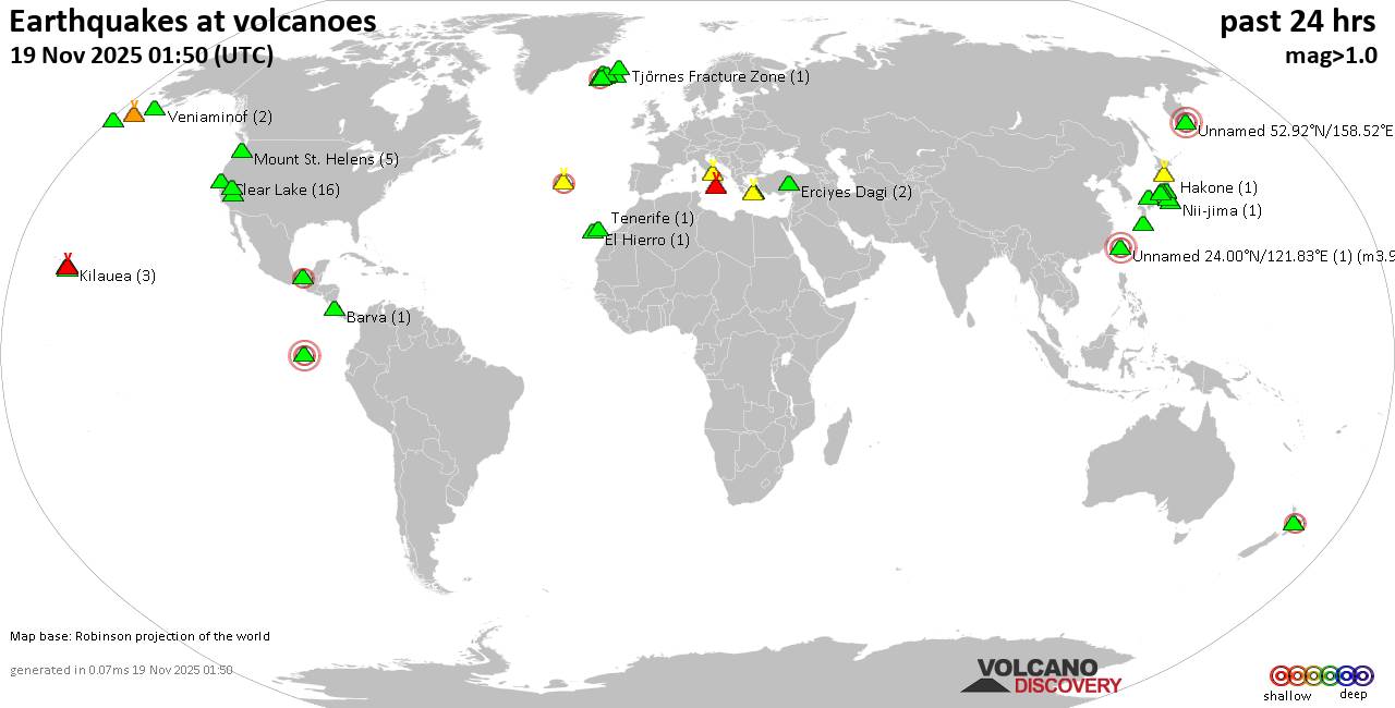
World map showing volcanoes with shallow (less than 50 km) earthquakes within 20 km radius during the past 24 hours on 19 Nov 2025 Number in brackets indicate nr of quakes.

Quakes detected near: Akita-Yake-yama (5 quakes between mag 0.2-1.1), Baluran (1 quake mag 2.7), Campi Flegrei (Phlegrean Fields) (38 quakes between mag 0.1-2.7), Clear Lake (36 quakes between mag 0.2-2.3), Cofre de Perote (3 quakes between mag 2.6-3.2), El Chichón (3 quakes between mag 2.3-2.8)
El Hierro (1 quake mag 1.9), Eldey (176 quakes between mag 0.2-2.8), Etna (1 quake mag 1.6), Hiuchi (2 quakes between mag 0.6-1.0), Irazu (1 quake mag 2.1), Katla (3 quakes between mag 0.4-1.2), Kawah Kamojang (1 quake mag 1.8), Kilauea (2 quakes between mag 1.7-1.9), Kolumbo (2 quakes between mag 1.8-2.0), Koruhüyüğü (1 quake mag 1.8), Kurikoma (6 quakes between mag 0.5-1.4), Ljósufjöll (6 quakes between mag 0.4-1.9), Martin (1 quake mag 1.3), Matutum (1 quake mag 2.7), Maunaloa (3 quakes between mag 1.4-2.0), Papandayan (7 quakes between mag 1.9-3.3), Pular (1 quake mag 3.0), Salton Buttes (1 quake mag 1.1), Santorini (1 quake mag 1.6), Taupo (1 quake mag 2.2), Tenorio (1 quake mag 1.6), Tjörnes Fracture Zone (1 quake mag 1.1), To-shima (2 quakes between mag 1.2-1.9), Yellowstone (1 quake mag 1.3)

Click this link to continue reading the article on the source website.