RSS feed source: Volcano Discovery.com--Global earthquake monitor

Wednesday, Nov 19, 2025 01:50 | 34 mins ago | By: EarthquakeMonitor

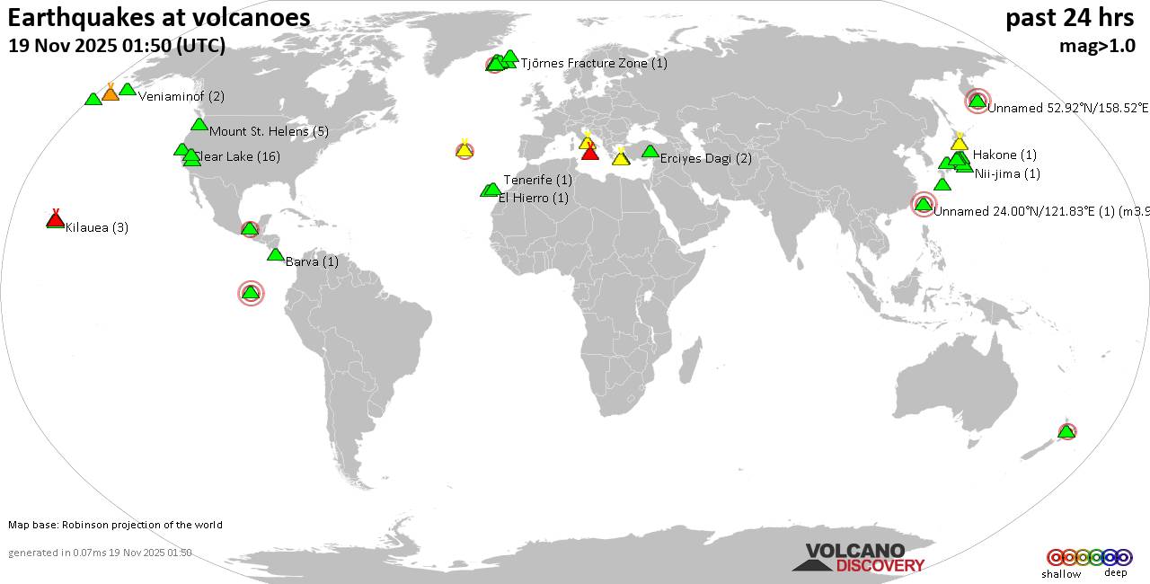
World map showing volcanoes with shallow (less than 50 km) earthquakes within 20 km radius during the past 24 hours on 19 Nov 2025 Number in brackets indicate nr of quakes.

Quakes detected near: Akagi (3 quakes between mag 0.5-1.6), Akuseki-jima (1 quake mag 1.8), Barva (1 quake mag 1.7), Campi Flegrei (Phlegrean Fields) (16 quakes between mag 0.1-1.8), Clear Lake (16 quakes between mag 0.6-1.2), Coso (2 quakes between mag 0.9-1.1)
Daisen (3 quakes between mag 0.3-1.2), El Chichón (2 quakes between mag 1.9-2.1), El Hierro (1 quake mag 1.9), Eldey (112 quakes between mag 0.2-2.3), Erciyes Dagi (2 quakes between mag 1.2-1.6), Etna (1 quake mag 1.3), Fagradalsfjall (2 quakes between mag 0.7-1.1), Fernandina (1 quake mag 3.1), Hakone (1 quake mag 2.1), Hiuchi (7 quakes between mag 0.2-1.0), Hrómundartindur (8 quakes between mag 0.4-1.1), Kilauea (3 quakes between mag 1.7-1.8), Kolumbo (3 quakes between mag 1.5-2.0), Ljósufjöll (4 quakes between mag 0.4-2.6), Loihi (1 quake mag 1.7), Loki-Fögrufjöll volcano (3 quakes between mag 0.6-1.7), Mammoth Mountain (1 quake mag 1.2), Mauna Kea (1 quake mag 1.9), Maunaloa (1 quake mag 1.4), Mount St. Helens (5 quakes between mag 0.2-1.2), Nii-jima (1 quake mag 1.7), Niigata-Yake-yama (1 quake mag 3.0), Okmok (1 quake mag 1.0), Prestahnukur (1 quake mag

Click this link to continue reading the article on the source website.
RSS feed source: Volcano Discovery.com--Global earthquake monitor

Date and TimeMag
DepthDistanceLocationDetailsMap Oct 15, 05:53 pm (Caracas)

4.2

40 km53 km (33 mi) to the S Caribbean Sea, 41 km southwest of Gueiria, Sucre, Venezuela 1 reportInfoAug 1, 07:52 pm (Caracas)

4.7

111 km18 km (11 mi) to the S Caribbean Sea, 48 km east of Carupano, Sucre, Venezuela 3 reportsInfoMay 25, 05:29 pm (Caracas)

4.1

42 km40 km (25 mi) to the E Caribbean Sea, 27 km northwest of Gueiria, Sucre, Venezuela 1 reportInfoMay 12, 02:49 am (GMT -4)

4.5

94 km47 km (29 mi) to the NE Caribbean Sea, 51 km north of Gueiria, Sucre, Venezuela 2 reportsInfoMay 11, 08:41 pm (Caracas)

5.0

86 km42 km (26 mi) to the E Caribbean Sea, 34 km north of Gueiria, Sucre, Venezuela 44 reportsInfoSep 27, 2024 07:39 pm (GMT -4)

4.8

119 km25 km (16 mi) to the NE Caribbean Sea, 82 km northeast of Carupano, Sucre, Venezuela 3 reportsInfoJun 22, 2024 11:57 pm (Caracas)

6.0

77 km21 km (13 mi) to the S Caribbean Sea, 44 km west of Gueiria, Sucre, Venezuela 649 reportsInfoFeb 5, 2024 10:18 pm (GMT -4)

4.9

89 km41 km (25 mi) to the E Caribbean Sea, 44 km north of Gueiria, Sucre, Venezuela 26 reportsInfoFeb 3, 2024 02:33 pm (GMT -4)

4.9

96 km36 km (22 mi) to the E Caribbean Sea, 47 km north of Gueiria, Sucre, Venezuela 23 reportsInfoJul 14, 2022 03:16 pm (Caracas)

5.3

108 km23 km (14 mi) to the SE 37 km northwest of Gueiria, Sucre, Venezuela 171 reportsInfoDec 7, 2021 03:43 pm (Caracas)

5.1

10 km67 km (42 mi) to the SE Caribbean Sea, 19 km south of Gueiria, Sucre, Venezuela 27 reportsInfoDec 7,

Click this link to continue reading the article on the source website.

RSS feed source: Volcano Discovery.com--Global earthquake monitor

<!–div style="font-size:14px;text-align:center;border:3px solid blue;border-radius:5px;padding:3px;margin:5px;background:#eee"><a href="https://www.volcanoesandearthquakes.com/app/volcano-report.php?volcanoId=44" style="text-decoration:none" target="_blank" rel="noopener noreferrer nofollow" title="Share a volcano (activity) report, submit a photo or other interesting news!” onclick=”window.open(this.href,’Volcano Report’,’status=0,toolbar=0,location=0,directories=0,menubar=0,resizable=1,scrollbars=1,height=500,width=450′);return false”>Send Volcano Report</div–> Stratovolcano 3676 m (12,060 ft)
East Java, Indonesia, -8.11°S / 112.92°E
Current status: erupting (4 out of 5) Semeru volcano eruptions:
1818, 1829, 1830, 1832, 1836, 1838, 1842, 1844, 1845, 1848, 1849(?), 1851, 1856, 1857, 1865, 1866(?), 1887, 1887, 1888, 1889-91, 1892, 1893, 1893-94, 1895, 1896, 1897, 1899, 1899, 1900, 1901, 1903, 1904, 1905, 1907, 1908, 1909-10, 1910-11, 1911, 1912, 1913, 1941-42, 1945, 1946, 1946-47, 1950-64, 1967-ongoing
Typical eruption style
Explosive. Near constant strombolian activity, occasionally stronger explosions, lava flows and pyroclastic flows.

Click this link to continue reading the article on the source website.

RSS feed source: Volcano Discovery.com--Global earthquake monitor

Wednesday, Nov 19, 2025 00:40 | 1 hour ago | By: EarthquakeMonitor

A very shallow magnitude 2.8 earthquake was reported early morning near Sitten, Sion District, Canton du Valais, Switzerland.
According to the European-Mediterranean Seismological Centre (EMSC), the quake hit on Wednesday, November 19th, 2025, at 1:31 am local time at a very shallow depth of 6.10 km. Shallow earthquakes are felt more strongly than deeper ones as they are closer to the surface. The exact magnitude, epicenter, and depth of the quake might be revised within the next few hours or minutes as seismologists review data and refine their calculations, or as other agencies issue their report.
Our monitoring service identified a second report from France’s Réseau National de Surveillance Sismique (RéNaSS) which listed the quake at magnitude 2.9.
Towns or cities near the epicenter where the quake might have been felt as very weak shaking include Chamonix (pop. 10,600) located 13 km from the epicenter, and Bourg-Saint-Pierre (pop. 210) 15 km away. In Martigny-Ville (pop. 14,800, 24 km away), Bagnes (pop. 6,600, 26 km away), Aosta (pop. 35,300, 28 km away), Sallanches (pop. 16,700, 32 km away), Cluses (pop. 19,800, 40 km away), Monthey (pop. 15,100, 41 km away), and Sitten (pop. 28,000, 45 km away), the quake was probably not felt.

If you felt it, report it through our site or app

Click this link to continue reading the article on the source website.