RSS feed source: Volcano Discovery.com--Global earthquake monitor

Date and TimeMag
DepthDistanceLocationDetailsMap Nov 6, 06:13 am (Mexico City)

4.7

176 km97 km (60 mi) to the SE Estado de Veracruz-Llave, 132 km northwest of Tuxtla, Estado de Chiapas, Mexico 6 reportsInfoNov 5, 06:36 am (Mexico City)

4.0

154 km98 km (61 mi) to the S Veracruz, Mexico InfoNov 2, 05:19 pm (Mexico City)

5.0

192 km63 km (39 mi) to the SE 19 km southwest of Las Choapas, Estado de Veracruz-Llave, Mexico 2 reportsInfoOct 31, 01:42 am (Mexico City)

4.1

162 km82 km (51 mi) to the S 52 km south of Minatitlán, Estado de Veracruz-Llave, Mexico InfoOct 29, 04:14 pm (Mexico City)

4.0

155 km77 km (48 mi) to the S Veracruz, Mexico InfoOct 24, 04:28 am (Mexico City)

4.1

164 km65 km (41 mi) to the S 35 km south of Minatitlán, Estado de Veracruz-Llave, Mexico InfoOct 11, 08:26 pm (Mexico City)

4.8

159 km93 km (58 mi) to the S 66 km south of Minatitlán, Estado de Veracruz-Llave, Mexico 6 reportsInfoSep 25, 03:11 pm (Mexico City)

4.7

181 km66 km (41 mi) to the SE 47 km southeast of Minatitlán, Estado de Veracruz-Llave, Mexico 1 reportInfoNov 19, 2023 04:08 am (Mexico City)

4.8

137 km98 km (61 mi) to the SW 68 km southwest of Minatitlán, Estado de Veracruz-Llave, Mexico InfoSep 26, 2023 11:40 am (Mexico City)

4.8

144 km95 km (59 mi) to the S 65 km south of Minatitlán, Estado de Veracruz-Llave, Mexico 2 reportsInfoAug 29, 2021 02:29 pm (Mexico City)

5.0

137 km76 km (47 mi) to the SW 18 km southwest of Acayucan, Estado de Veracruz-Llave, Mexico 6 reportsInfoApr 17, 2021 10:31 am (Mexico City)

4.8

149 km80 km (50 mi) to the S

Click this link to continue reading the article on the source website.

RSS feed source: Volcano Discovery.com--Global earthquake monitor

3 km (2 mi)

NW of epicenter

La Virtud

(pop: 1,320)

III: Weak

Departamento de Lempira 20 km (13 mi)

S of epicenter

Sensuntepeque

(pop: 20,400)

III: Weak

Departamento de Cabanas 27 km (17 mi)

W of epicenter

Chalatenango

(pop: 19,400)

III: Weak

Departamento de Chalatenango 32 km (20 mi)

NE of epicenter

Erandique

(pop: 1,880)

III: Weak

Departamento de Lempira 33 km (20 mi)

E of epicenter

Camasca

(pop: 1,150)

III: Weak

Departamento de Intibuca 36 km (22 mi)

NW of epicenter

Cololaca

(pop: 1,010)

III: Weak

Departamento de Lempira 38 km (24 mi)

SW of epicenter

San Sebastian

(pop: 7,330)

III: Weak

Departamento de San Vicente 39 km (24 mi)

SW of epicenter

San Martin

(pop: 39,400)

III: Weak

Departamento de Cuscatlan 40 km (25 mi)

W of epicenter

Suchitoto

(pop: 5,740)

III: Weak

Departamento de Cuscatlan 50 km (31 mi)

NW of epicenter

San Marcos

(pop: 5,350)

II: Very weak

Departamento de Ocotepeque 51 km (31 mi)

N of epicenter

Belen Gualcho

(pop: 2,360)

II: Very weak

Belen Gualcho, Departamento de Ocotepeque 54 km (34 mi)

SE of epicenter

Ciudad Barrios

(pop: 8,490)

II: Very weak

Departamento de San Miguel 56 km (35 mi)

W of epicenter

Aguilares

(pop: 21,400)

II: Very weak

Departamento de San Salvador

Click this link to continue reading the article on the source website.

RSS feed source: Volcano Discovery.com--Global earthquake monitor

Thursday, Nov 20, 2025 09:50 | 36 mins ago | By: EarthquakeMonitor

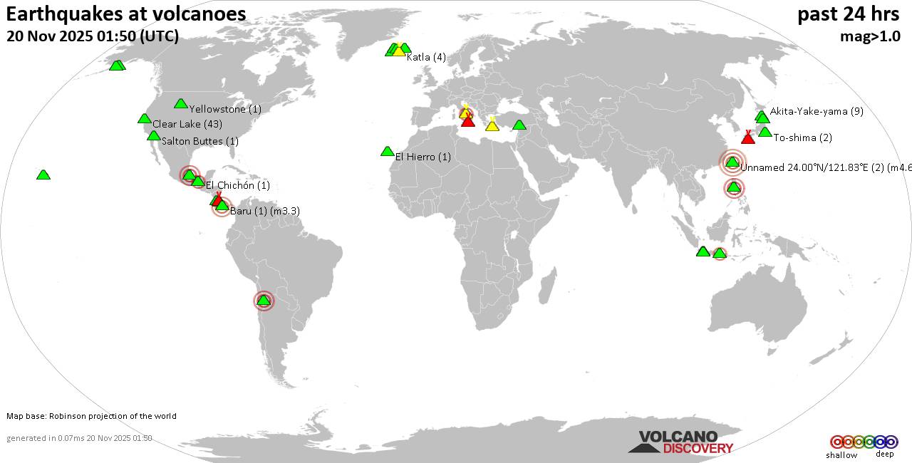
World map showing volcanoes with shallow (less than 50 km) earthquakes within 20 km radius during the past 24 hours on 20 Nov 2025 Number in brackets indicate nr of quakes.

Quakes detected near: Akita-Yake-yama (8 quakes between mag 0.2-1.1), Arayat (1 quake mag 3.0), Askja (3 quakes between mag 0.7-1.7), Baluran (1 quake mag 2.7), Baru (1 quake mag 3.3), Campi Flegrei (Phlegrean Fields) (57 quakes between mag 0.1-2.7)
Clear Lake (43 quakes between mag 0.2-2.1), Cleveland (1 quake mag 1.0), Cofre de Perote (1 quake mag 2.8), El Chichón (2 quakes between mag 2.0-2.2), El Hierro (1 quake mag 1.2), Eldey (4 quakes between mag 1.4-1.9), Hrómundartindur (6 quakes between mag 0.1-1.3), Irazu (1 quake mag 2.1), Katla (4 quakes between mag 0.0-1.4), Kawah Kamojang (1 quake mag 1.8), Kilauea (1 quake mag 1.9), Kirishima (3 quakes between mag 0.2-1.1), Koruhüyüğü (1 quake mag 1.8), Kukak (1 quake mag 1.9), Ljósufjöll (11 quakes between mag 0.1-1.9), Loki-Fögrufjöll volcano (5 quakes between mag 0.3-1.0), Maroa (1 quake mag 1.1), Maunaloa (2 quakes between mag 1.0-1.8), Ngauruhoe (1 quake mag 1.3), Papandayan (6 quakes between mag 1.9-3.3), Poas (1 quake mag 2.4), Prestahnukur (1 quake mag 1.2), Salton Buttes (1 quake mag 1.1), Santorini (1 quake mag 1.6), Shishaldin (5 quakes

Click this link to continue reading the article on the source website.