RSS feed source: Volcano Discovery.com--Global earthquake monitor

Date and TimeMag
DepthDistanceLocationDetailsMap Sep 22, 09:06 pm (Jayapura)

4.5

128 km29 km (18 mi) to the E Banda Sea, 17 km south of Pulau Saparua Island, Maluku, Indonesia 1 reportInfoSep 20, 03:54 pm (Jayapura)

4.8

10 km59 km (37 mi) to the W Banda Sea, 35 km west of Ambon, Kota Ambon, Maluku, Indonesia 4 reportsInfoSep 2, 10:17 pm (Jayapura)

4.2

10 km88 km (54 mi) to the NE Banda Sea, 24 km east of Amahai, Kabupaten Maluku Tengah, Maluku, Indonesia InfoSep 2, 10:10 pm (Jayapura)

4.4

10 km84 km (52 mi) to the NE Banda Sea, 19 km east of Amahai, Kabupaten Maluku Tengah, Maluku, Indonesia InfoSep 2, 11:02 am (GMT +9)

4.5

10 km51 km (31 mi) to the SE Banda Sea, 54 km south of Pulau Saparua Island, Maluku, Indonesia InfoJan 10, 01:47 am (Jayapura)

5.3

261 km93 km (58 mi) to the SE Banda Sea, 112 km southeast of Ambon, Kota Ambon, Maluku, Indonesia InfoJun 1, 2023 06:56 am (Jayapura)

5.5

95 km23 km (14 mi) to the NW Kabupaten Maluku Tengah, 23 km northeast of Ambon, Kota Ambon, Maluku, Indonesia InfoJan 25, 2020 09:38 am (Jayapura)

5.1

15 km80 km (49 mi) to the NW Kabupaten Seram Bagian Barat, 67 km northwest of Ambon, Indonesia InfoNov 12, 2019 07:10 pm (Jayapura)

5.1

39 km12 km (7.4 mi) to the NW 19 km northeast of Ambon, Kota Ambon, Maluku, Indonesia 14 reportsInfoSep 26, 2019 09:39 am (Jayapura)

5.3

10 km9.9 km (6.2 mi) to the NE Banda Sea, 33 km east of Ambon, Kota Ambon, Maluku, Indonesia 1 reportInfoSep 26, 2019 08:46 am (Jayapura)

6.4

10 km16 km (9.7 mi) to the N

Click this link to continue reading the article on the source website.

RSS feed source: Volcano Discovery.com--Global earthquake monitor

Moderate magnitude 4.6 earthquake at 126 km depth

20 Nov 06:53 UTC: First to report: VolcanoDiscovery after 3 minutes.
20 Nov 07:16: Now using data updates from USGS

I didn’t feel it

I felt this quake

Earthquake details Date & timeNov 20, 2025 06:51:25 UTC – Local time at epicenterThursday, Nov 20, 2025, at 04:51 pm (Pacific/Saipan GMT +10) Statusconfirmed (manually revised) Magnitude4.6 Depth126 km Epicenter latitude / longitude14.0582°N / 145.0534°E Northern Mariana IslandsAlso near: Guam 49 km (30 mi) away Seismic antipode14.0582°S / 34.947°W Quality77 seismic stations Shaking intensityIII Weak shaking near epicenter Felt2 reports Primary data sourceUSGS (United States Geological Survey) Nearest volcanoSeamount X (74 km / 46 mi) Weather at epicenter at time of quakeFew Clouds 28°C (82 F), humidity: 83%, wind: 8 m/s (16 kts) from E Estimated seismic energy released5 x 1011 joules (139 megawatt hours, equivalent to 120 tons of TNT) | equivalent to ONE quake of magnitude 4.6 | about seismic energy

[smaller] [bigger]

Nearby places The closest larger town where the quake might have been felt is Dededo Village, a town with 45,000 inhabitants in Guam, in 64 km (40 mi) distance south of the epicenter. People likely experienced very weak shaking there. In the capital of the  Northern Mariana Islands, Saipan, 149 km (93 mi) away from

Click this link to continue reading the article on the source website.

RSS feed source: Volcano Discovery.com--Global earthquake monitor

Thursday, Nov 20, 2025 05:20 | 59 mins ago | By: EarthquakeMonitor

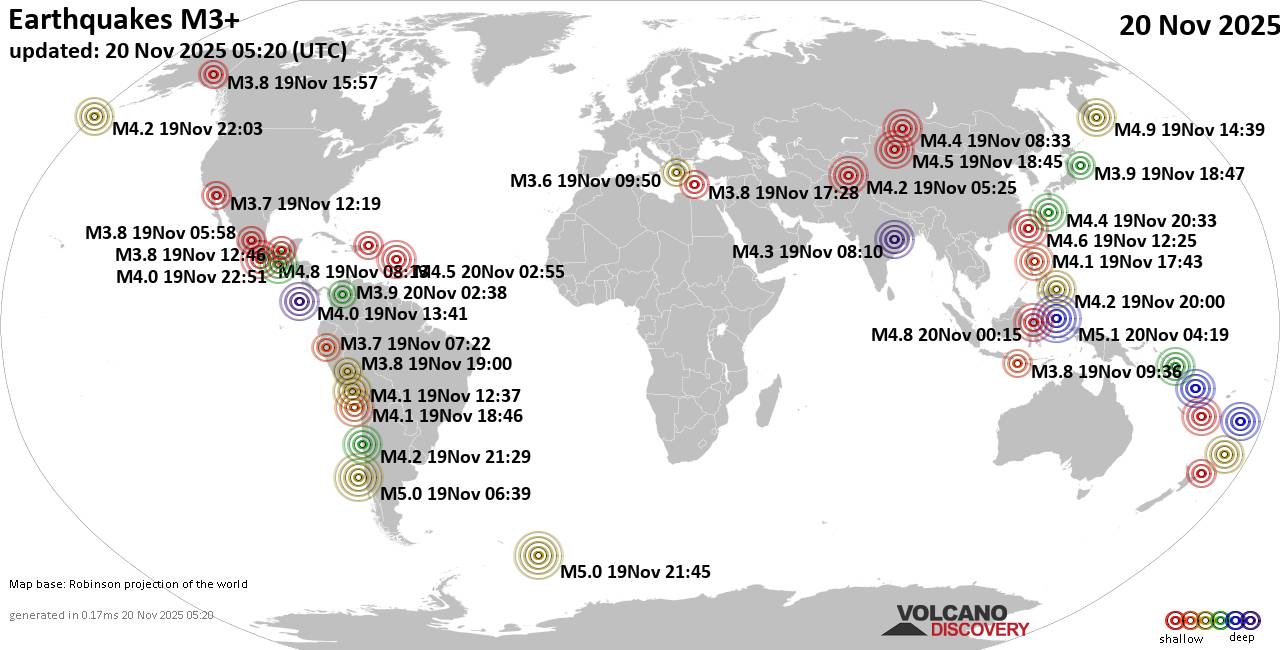
Worldwide earthquakes above magnitude 3 during the past 24 hours on 20 Nov 2025

Summary: 3 quakes 5.0+, 43 quakes 4.0+, 170 quakes 3.0+, 321 quakes 2.0+ (537 total)
This report is being updated every hour.
Magnitude 5+: 3 earthquakes
Magnitude 4+: 43 earthquakes
Magnitude 3+: 170 earthquakes
Magnitude 2+: 321 earthquakes
No quakes of magnitude 6 or higherTotal seismic energy estimate: 2.5 x 10¹³ joules (6.85 gigawatt hours, equivalent to 5898 tons of TNT or 0.4 atomic bombs!) | equivalent to ONE quake of magnitude 5.7 learn more10 largest earthquakes in the world (past 24 hours)#1: Mag 5.1 Maluku Sea, 95 km north of Ternate, Kota Ternate, North Maluku, IndonesiaThursday, Nov 20, 2025, at 01:19 pm (GMT +9) – #2: Mag 5.0 South Pacific Ocean, 132 km west of Lebu, Arauco, Region del Biobio, ChileWednesday, Nov 19, 2025, at 01:39 am (GMT -5) – #3: Mag 5.0 South Atlantic Ocean, 84 km northeast of Montagu Island, South Georgia and the South Sandwich IslandsWednesday, Nov 19, 2025, at 07:45 pm (GMT -2) – #4: Mag 4.9 North Pacific Ocean, 157 km southeast of Petropavlovsk-Kamchatskiy, Kamchatka, RussiaThursday, Nov 20, 2025, at 01:39 am (GMT +11) – #5: Mag 4.9 South Pacific Ocean, 397 km east of Mare Island, Loyalty Islands, New CaledoniaThursday, Nov 20, 2025, at 03:22

Click this link to continue reading the article on the source website.
RSS feed source: Volcano Discovery.com--Global earthquake monitor

Support Us – Help Us Enhance Our Services! We’re passionate about delivering the latest volcano and earthquake data from around the globe — just for you. However, maintaining our website and free apps requires significant time, effort, and resources.
Your support helps us expand our hardware and software capabilities and empowers our dedicated editorial team. Our mission is to provide uninterrupted, real-time updates whenever an earthquake strikes or a volcano erupts — and your donations make this possible. Every contribution, big or small, is deeply appreciated. If you find our information valuable and want to help us add new features, create compelling content, and improve our technology, please consider making a donation: Donate with PayPal: Planned Features: Improved multilingual support Tsunami alerts Faster responsiveness Thanks to your past donations, we have recently added: Design upgrades Detailed earthquake

Click this link to continue reading the article on the source website.