RSS feed source: Volcano Discovery.com--Global earthquake monitor

Thu, 6 Nov 2025, 23:10 | BY: EARTHQUAKEMONITOR

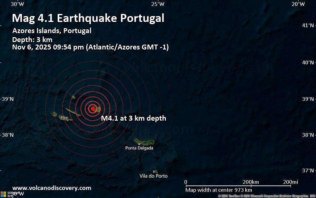
A magnitude 4.1 earthquake near Angra do Heroismo, Angra do Heroísmo Municipality, Azores, Portugal, was reported only 15 minutes ago by the European-Mediterranean Seismological Centre (EMSC), considered one of the key international agencies that monitor seismic activity worldwide. The earthquake occurred at a very shallow depth of 2.80 km beneath the epicenter in the evening on Thursday, November 6th, 2025, at 9:54 pm local time. The exact magnitude, epicenter, and depth of the quake might be revised within the next few hours or minutes as seismologists review data and refine their calculations, or as other agencies issue their report.
Our monitoring service identified a second report from the Portuguese Institute for Sea and Atmosphere (Instituto Português do Mar e da Atmosfera, IPMA) which listed the quake at magnitude 4.1 as well.
Based on the preliminary seismic data, the quake was probably felt by many people in the area of the epicenter. It should not have caused significant damage, other than objects falling from shelves, broken windows, etc.
In Santa Barbara (pop. 1,300) located 4 km from the epicenter, Sao Bartolomeu (pop. 2,000) 7 km away, Biscoitos (pop. 1,400) 9 km away, and Sao Mateus (pop. 3,800) 10 km away, the quake should have been felt as light shaking.
Weak shaking might have been felt in Angra do

Click this link to continue reading the article on the source website.

RSS feed source: Volcano Discovery.com--Global earthquake monitor

Date and TimeMag
DepthDistanceLocationDetailsMap Oct 29, 05:10 pm (GMT +13)

4.0

300 km84 km (52 mi) to the NW New Zealand InfoOct 29, 04:48 am (GMT +13)

4.0

100 km65 km (40 mi) to the NW New Zealand InfoOct 24, 04:02 pm (GMT -12)

4.3

33 km48 km (30 mi) to the S New Zealand InfoOct 24, 12:30 pm (GMT +12)

4.1

33 km28 km (17 mi) to the SE New Zealand 1 reportInfoOct 23, 02:24 am (GMT -12)

5.0

33 km77 km (48 mi) to the E New Zealand InfoOct 21, 08:02 am (GMT -12)

5.2

33 km81 km (50 mi) to the SE Marlborough, New Zealand InfoOct 15, 01:07 am (GMT -12)

5.5

33 km87 km (54 mi) to the SE New Zealand InfoOct 9, 10:52 am (GMT -12)

4.4

33 km62 km (38 mi) to the SE New Zealand InfoOct 9, 01:22 am (GMT -12)

4.8

33 km66 km (41 mi) to the SE New Zealand InfoOct 8, 2024 11:59 am (GMT +12)

6.1

33 km82 km (51 mi) to the E New Zealand 1 reportInfoJun 27, 2024 04:37 am (GMT -12)

6.3

33 km26 km (16 mi) to the NE New Zealand 2 reportsInfoSep 8, 2023 09:09 pm (GMT +12)

6.9

100 km74 km (46 mi) to the NE New Zealand 96 reportsInfoDec 21, 2022 04:38 am (GMT +12)

6.3

33 km42 km (26 mi) to the S New Zealand 1 reportInfoMay 18, 2021 08:59 pm (GMT +12)

5.9

33 km68 km (42 mi) to the NE New Zealand 1 reportInfoJan 23, 2021 04:23 am (GMT +12)

5.9

33 km49 km (30 mi) to the NE New Zealand InfoDec 11, 2020 08:42 am (GMT +12)

6.3

33 km49 km (30 mi) to the NE New Zealand 3 reportsInfoJun 19, 2020 12:38 pm (GMT +12)

5.9

33 km80 km (50 mi) to the E New

Click this link to continue reading the article on the source website.

RSS feed source: Volcano Discovery.com--Global earthquake monitor

Support Us – Help Us Enhance Our Services! We’re passionate about delivering the latest volcano and earthquake data from around the globe — just for you. However, maintaining our website and free apps requires significant time, effort, and resources.
Your support helps us expand our hardware and software capabilities and empowers our dedicated editorial team. Our mission is to provide uninterrupted, real-time updates whenever an earthquake strikes or a volcano erupts — and your donations make this possible. Every contribution, big or small, is deeply appreciated. If you find our information valuable and want to help us add new features, create compelling content, and improve our technology, please consider making a donation: Donate with PayPal: Planned Features: Improved multilingual support Tsunami alerts Faster responsiveness Thanks to your past donations, we have recently added: Design upgrades Detailed earthquake statistics Additional seismic data sources Download the Volcanoes & Earthquakes app to stay among the first to receive the fastest seismic and volcano alerts online:
Android | iOS

Thank you for being part of our mission!

Click this link to continue reading the article on the source website.

RSS feed source: Volcano Discovery.com--Global earthquake monitor

Date and TimeMag
DepthDistanceLocationDetailsMap Jul 25, 12:36 am (Lima)

4.0

124 km56 km (35 mi) to the E Ucayali, 81 km northeast of Satipo, Junin, Peru InfoJul 18, 07:30 pm (Lima)

4.3

10 km67 km (42 mi) to the NE 210 km south of Pucallpa, Ucayali, Peru InfoJul 11, 12:18 pm (Lima)

4.6

23 km53 km (33 mi) to the W 118 km northeast of Junin, Junin, Peru 1 reportInfoJun 6, 01:37 pm (Lima)

4.0

124 km97 km (61 mi) to the W 4.3 km southeast of Oxapampa, Pasco, Peru InfoMay 16, 04:21 am (Lima)

4.0

20 km98 km (61 mi) to the N Central Peru InfoMar 5, 2022 02:45 am (Lima)

5.1

136 km48 km (30 mi) to the NE Ucayali, 90 km northeast of Santa Rosa, Junin, Peru 7 reportsInfoMar 13, 2018 12:35 pm (Lima)

5.1

36 km79 km (49 mi) to the NW Pasco, 73 km north of Santa Rosa, Junin, Peru InfoOct 30, 2017 12:12 pm (Lima)

5.3

112 km19 km (12 mi) to the W Central Peru 7 reportsInfoAug 13, 2017 11:51 am (Lima)

5.7

29 km12 km (7.5 mi) to the N Central Peru 5 reportsInfoNov 24, 2015 06:32 pm (Lima)

5.4

619 km90 km (56 mi) to the SE 13 km northwest of San Antonio de Cheni, Junin, Peru InfoOct 26, 2014 05:45 am (Lima)

5.7

116 km64 km (40 mi) to the NE 23 km south of Puntijao, Ucayali, Peru 1 reportInfoSep 23, 2006 08:12 pm (Lima)

5.2

108 km56 km (35 mi) to the SW 11 km west of Satipo, Junin, Peru InfoJun 7, 2005 11:20 am (Lima)

5.3

126 km32 km (20 mi) to the E Ucayali, 75 km east of Santa Rosa, Junin, Peru InfoJul 31, 2003

Click this link to continue reading the article on the source website.