RSS feed source: US National Weather Service

At 925 PM CDT, a severe thunderstorm was located near Pink, moving southeast at 15 mph. HAZARD…60 mph wind gusts and quarter size hail. SOURCE…Radar indicated. IMPACT…Hail damage to vehicles is expected. Expect wind damage to roofs, siding, and trees. Locations impacted include… Shawnee, Pink, and Bethel Acres.

Click this link to continue reading the article on the source website.

RSS feed source: US National Weather Service

Fri, 24 Oct 2025, 00:50 | BY: EARTHQUAKEMONITOR

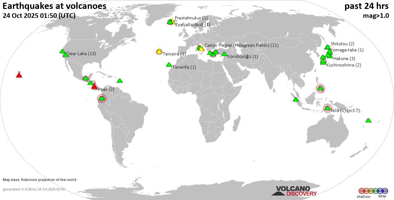
World map showing volcanoes with shallow (less than 50 km) earthquakes within 20 km radius during the past 24 hours on 24 Oct 2025 Number in brackets indicate nr of quakes.

Quakes detected near: Abu (10 quakes between mag 0.1-1.1), Bandai (1 quake mag 1.3), Brennisteinsfjöll (2 quakes between mag 1.2-2.3), Campi Flegrei (Phlegrean Fields) (21 quakes between mag 0.1-1.2), Clear Lake (15 quakes between mag 0.1-1.6), Colli Albani (1 quake mag 2.0)
Coso (1 quake mag 1.5), Cuernos de Negros (2 quakes between mag 3.0-3.0), El Chichón (16 quakes between mag 1.9-3.3), Eyafjallajökull (1 quake mag 1.3), Galeras (1 quake mag 3.0), Hakone (2 quakes between mag 0.7-1.1), Ibusuku (1 quake mag 2.2), Katla (4 quakes between mag 0.6-1.1), Kenger (3 quakes between mag 0.9-1.2), Kilauea (4 quakes between mag 1.5-1.7), Kolumbo (3 quakes between mag 1.5-2.0), Komaga-take (1 quake mag 1.0), Koruhüyüğü (1 quake mag 1.8), Krísuvík (25 quakes between mag 0.1-1.8), Kuchinoshima (2 quakes between mag 2.1-2.5), Kurikoma (2 quakes between mag 0.9-1.0), Kuwae (1 quake mag 1.7), Laguna Aramuaca (3 quakes between mag 1.4-2.0), Morne Plat Pays (1 quake mag 1.6), Nila (1 quake mag 3.7), Poas (2 quakes between mag 1.5-2.1), Prestahnukur (1 quake mag 1.4), Sandal (2 quakes between mag 1.1-1.2), Sarik-Gajah (2 quakes between mag 1.7-2.2), Shikotsu (2 quakes

Click this link to continue reading the article on the source website.
RSS feed source: US National Weather Service

Date and TimeMag
DepthDistanceLocationDetailsMap Oct 21, 07:11 am (GMT -2)

5.0

79 km60 km (38 mi) to the SE South Sandwich Islands Region  I FELT IT InfoOct 11, 11:08 am (GMT -2)

5.5

55 km91 km (57 mi) to the SE South Sandwich Islands Region InfoOct 11, 06:06 am (GMT -2)

5.4

45 km88 km (55 mi) to the E South Sandwich Islands Region InfoSep 13, 02:32 am (GMT -2)

5.4

55 km44 km (27 mi) to the N South Sandwich Islands Region InfoSep 12, 01:31 am (South Georgia)

5.3

10 km35 km (22 mi) to the S South Sandwich Islands Region InfoJun 15, 01:18 am (GMT -2)

5.3

10 km80 km (50 mi) to the E South Sandwich Islands Region InfoJan 1, 11:48 am (GMT -2)

6.1

70 km85 km (53 mi) to the SE South Sandwich Islands Region InfoAug 12, 2021 04:32 pm (GMT -2)

7.5

47 km245 km (152 mi) to the SE South Sandwich Islands Region 3 reportsInfoApr 5, 2019 02:14 pm (GMT -2)

6.4

65 km4.7 km (2.9 mi) to the SW South Sandwich Islands Region InfoDec 11, 2018 12:26 am (South Georgia)

7.0

150 km299 km (186 mi) to the S South Sandwich Islands Region 3 reportsInfoAug 19, 2016 05:32 am (GMT -2)

7.3

20 km264 km (164 mi) to the W South Georgia Island Region 1 reportInfoMay 28, 2016 07:47 am (GMT -2)

7.1

75 km62 km (38 mi) to the SE South Sandwich Islands Region InfoApr 19, 2016 03:25 am (GMT -2)

6.2

10 km45 km (28 mi) to the NE South Sandwich Islands Region InfoFeb 16, 2015 08:00 pm (GMT -2)

6.1

10 km55 km (34 mi) to the NW South Sandwich Islands Region InfoJun 29, 2014 05:52 am (GMT -2)

6.9

10 km66 km (41 mi) to the

Click this link to continue reading the article on the source website.