RSS feed source: USGS Earthquake Hazards Program
Time2025-11-09 09:28:23 UTC2025-11-09 09:28:23 UTC at epicenterLocation39.629°N 143.505°EDepth10.00 km (6.21 mi)
Click this link to continue reading the article on the source website.
RSS feed source: USGS Earthquake Hazards Program
Time2025-11-09 09:28:23 UTC2025-11-09 09:28:23 UTC at epicenterLocation39.629°N 143.505°EDepth10.00 km (6.21 mi)
Click this link to continue reading the article on the source website.
RSS feed source: USGS Earthquake Hazards Program
Time2025-11-09 09:36:50 UTC2025-11-09 09:36:50 UTC at epicenterLocation52.170°N 171.409°WDepth43.40 km (26.96 mi)
Click this link to continue reading the article on the source website.
RSS feed source: USGS Earthquake Hazards Program
Date and TimeMag
DepthDistanceLocationDetailsMap Nov 9, 07:37 pm (GMT +10)
4.3
21 km27 km (17 mi) to the NE North Pacific Ocean, 217 km east of Morioka, Iwate, Japan I FELT IT InfoNov 9, 07:28 pm (GMT +10)
5.7
10 km26 km (16 mi) to the N North Pacific Ocean, 202 km east of Morioka, Iwate, Japan I FELT IT – 1 reportInfoNov 9, 06:24 pm (GMT +9)
4.7
29 km7.9 km (4.9 mi) to the W North Pacific Ocean, 122 km east of Miyako, Iwate, Japan I FELT IT InfoNov 9, 07:20 pm (GMT +10)
4.2
30 km3.9 km (2.4 mi) to the W North Pacific Ocean, 194 km east of Morioka, Iwate, Japan I FELT IT InfoNov 9, 09:16 am (Universal Time)
5.0
10 km24 km (15 mi) to the W North Pacific Ocean, 109 km east of Miyako, Iwate, Japan I FELT IT InfoNov 9, 07:10 pm (GMT +10)
5.4
10 km10.7 km (6.6 mi) to the N North Pacific Ocean, 192 km east of Morioka, Iwate, Japan I FELT IT – 1 reportInfoNov 9, 06:54 pm (GMT +10)
6.4
10 km8.4 km (5.2 mi) to the NW North Pacific Ocean, 191 km east of Morioka, Iwate, Japan I FELT IT – 1 reportInfoNov 9, 06:49 pm (GMT +10)
5.2
10 km7.2 km (4.4 mi) to the S North Pacific Ocean, 197 km east of Morioka, Iwate, Japan I FELT IT InfoNov 9, 06:34 pm (GMT +10)
5.6
10 km6.6 km (4.1 mi) to the N North Pacific Ocean, Aomori, 196 km east of Morioka, Iwate, Japan I FELT IT – 1 reportInfoNov 9, 06:03
Click this link to continue reading the article on the source website.
RSS feed source: USGS Earthquake Hazards Program
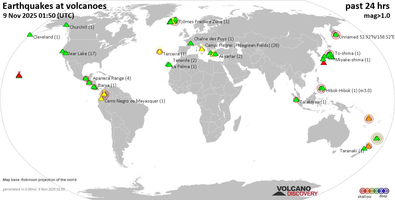
Sun, 9 Nov 2025, 09:50 | BY: EARTHQUAKEMONITOR
World map showing volcanoes with shallow (less than 50 km) earthquakes within 20 km radius during the past 24 hours on 9 Nov 2025 Number in brackets indicate nr of quakes.
Quakes detected near: Akagi (2 quakes between mag 1.0-1.1), Akyarlar (2 quakes between mag 1.6-2.1), Aoba (1 quake mag 3.5), Apaneca Range (2 quakes between mag 1.8-2.0), Campi Flegrei (Phlegrean Fields) (46 quakes between mag 0.1-2.2), Chaîne des Puys (1 quake mag 1.9)
Chiginagak (1 quake mag 2.3), Ciremai (1 quake mag 2.5), Clear Lake (13 quakes between mag 0.4-2.1), Cuernos de Negros (2 quakes between mag 3.0-3.0), El Chichón (3 quakes between mag 1.9-2.8), Eldey (4 quakes between mag 0.7-2.0), Eyafjallajökull (2 quakes between mag 0.4-1.3), Grímsnes (3 quakes between mag 1.1-1.4), Hakone (1 quake mag 1.1), Havre Seamount (1 quake mag 4.0), Hekla (2 quakes between mag 1.1-2.0), Kilauea (1 quake mag 1.9), Kolumbo (2 quakes between mag 1.2-1.2), Kverkfjöll (1 quake mag 1.0), La Palma (1 quake mag 1.2), Lavic Lake (1 quake mag 1.0), Ljósufjöll (4 quakes between mag 0.4-1.6), Loihi (3 quakes between mag 1.7-1.8), Mammoth Mountain (1 quake mag 1.5), Masaya (1 quake mag 2.7), Maunaloa (3 quakes between mag 1.7-2.2), Nantai (6 quakes between mag 0.1-1.3), Salton Buttes (2 quakes between mag 1.8-2.0), Sanbe (7 quakes between mag
Click this link to continue reading the article on the source website.