RSS feed source: Volcano Discovery.com--Global earthquake monitor

Sunday, Nov 16, 2025 00:50 | 49 mins ago | By: EarthquakeMonitor

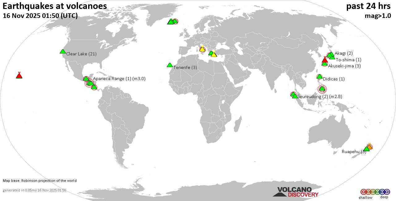
World map showing volcanoes with shallow (less than 50 km) earthquakes within 20 km radius during the past 24 hours on 16 Nov 2025 Number in brackets indicate nr of quakes.

Quakes detected near: Akagi (2 quakes between mag 0.3-1.3), Akuseki-jima (4 quakes between mag 1.1-2.0), Apaneca Range (1 quake mag 3.0), Bardarbunga (7 quakes between mag 0.1-2.8), Campi Flegrei (Phlegrean Fields) (21 quakes between mag 0.1-2.1), Clear Lake (20 quakes between mag 0.2-1.4)
Cuernos de Negros (3 quakes between mag 3.0-3.0), Didicas (1 quake mag 2.2), El Chichón (11 quakes between mag 1.4-3.6), Eldey (8 quakes between mag 1.2-1.7), Geureudong (2 quakes between mag 2.7-2.8), Hrómundartindur (10 quakes between mag 0.1-1.2), Kilauea (3 quakes between mag 1.7-2.4), Kirishima (7 quakes between mag 0.2-1.2), Kolumbo (3 quakes between mag 1.2-2.1), Krísuvík (3 quakes between mag 0.0-1.0), Laguna Aramuaca (1 quake mag 2.0), Ljósufjöll (3 quakes between mag 0.3-1.3), Loihi (1 quake mag 1.7), Methana (1 quake mag 1.3), Nantai (1 quake mag 1.1), Ruapehu (2 quakes between mag 0.8-1.3), Santorini (1 quake mag 1.7), Sinabung (1 quake mag 2.0), Sousaki (1 quake mag 1.2), Suoh (1 quake mag 2.3), Tenerife (3 quakes between mag 1.1-1.5), Tongariro (1 quake mag 1.0), White Island (1 quake mag 2.5), Yake-dake (14 quakes between

Click this link to continue reading the article on the source website.
RSS feed source: Volcano Discovery.com--Global earthquake monitor

<!–div style="font-size:14px;text-align:center;border:3px solid blue;border-radius:5px;padding:3px;margin:5px;background:#eee"><a href="https://www.volcanoesandearthquakes.com/app/volcano-report.php?volcanoId=44" style="text-decoration:none" target="_blank" rel="noopener noreferrer nofollow" title="Share a volcano (activity) report, submit a photo or other interesting news!” onclick=”window.open(this.href,’Volcano Report’,’status=0,toolbar=0,location=0,directories=0,menubar=0,resizable=1,scrollbars=1,height=500,width=450′);return false”>Send Volcano Report</div–> Stratovolcano 3676 m (12,060 ft)
East Java, Indonesia, -8.11°S / 112.92°E
Current status: erupting (4 out of 5) Semeru volcano eruptions:
1818, 1829, 1830, 1832, 1836, 1838, 1842, 1844, 1845, 1848, 1849(?), 1851, 1856, 1857, 1865, 1866(?), 1887, 1887, 1888, 1889-91, 1892, 1893, 1893-94, 1895, 1896, 1897, 1899, 1899, 1900, 1901, 1903, 1904, 1905, 1907, 1908, 1909-10, 1910-11, 1911, 1912, 1913, 1941-42, 1945, 1946, 1946-47, 1950-64, 1967-ongoing
Typical eruption style
Explosive. Near constant strombolian activity, occasionally stronger explosions, lava flows and pyroclastic flows.

Click this link to continue reading the article on the source website.

RSS feed source: Volcano Discovery.com--Global earthquake monitor

Date and TimeMag
DepthDistanceLocationDetailsMap Nov 15, 08:24 pm (GMT +13)

4.0

300 km73 km (46 mi) to the SW Bay of Plenty, New ZealandI FELT IT InfoNov 7, 05:27 pm (GMT +13)

4.4

300 km48 km (30 mi) to the E Hawke’s Bay, New Zealand InfoOct 22, 09:40 pm (GMT +13)

4.1

100 km94 km (58 mi) to the S South Pacific Ocean, Gisborne, 108 km south of Raoul Island, New Zealand InfoOct 22, 05:07 pm (GMT +13)

4.1

300 km95 km (59 mi) to the SE Gisborne, New Zealand InfoOct 15, 10:10 pm (GMT +13)

4.3

33 km73 km (45 mi) to the SW South Pacific Ocean, Gisborne, 63 km south of Raoul Island, New Zealand InfoAug 21, 05:13 am (GMT +12)

4.7

33 km87 km (54 mi) to the S New Zealand InfoJun 27, 01:14 am (GMT +12)

4.8

10 km93 km (58 mi) to the SE South Pacific Ocean, 145 km southeast of Raoul Island, New Zealand InfoJun 8, 01:20 am (GMT +12)

5.0

349 km86 km (54 mi) to the SW New Zealand InfoJun 6, 05:53 am (GMT +12)

4.5

27 km90 km (56 mi) to the SW South Pacific Ocean, 98 km south of Raoul Island, New Zealand InfoJun 1, 2024 03:54 am (GMT +12)

6.1

33 km70 km (43 mi) to the E South Pacific Ocean, Gisborne, 120 km east of Raoul Island, New Zealand 1 reportInfoFeb 9, 2024 11:57 pm (GMT +13)

6.2

10 km32 km (20 mi) to the N South Pacific Ocean, Gisborne, 62 km east of Raoul Island, New Zealand 1 reportInfoApr 24, 2023 12:41 pm (GMT +12)

6.8

33 km88 km (54 mi) to the SE New Zealand 1 reportInfoAug 31,

Click this link to continue reading the article on the source website.

RSS feed source: Volcano Discovery.com--Global earthquake monitor

Date and TimeMag
DepthDistanceLocationDetailsMap Oct 10, 03:11 pm (Lima)

4.1

10 km86 km (53 mi) to the N 7.1 km northeast of Abancay, Region de Apurimac, Peru 2 reportsInfoOct 7, 03:52 pm (Lima)

4.1

102 km32 km (20 mi) to the N 51 km south of Abancay, Region de Apurimac, Peru 1 reportInfoSep 26, 09:39 pm (Lima)

4.4

100 km77 km (48 mi) to the S 56 km west of Orcopampa, Arequipa, Peru InfoSep 26, 08:44 am (Lima)

4.3

112 km96 km (60 mi) to the SW 33 km north of Coracora, Ayacucho, Peru InfoAug 7, 02:59 am (Lima)

4.0

88 km18 km (11 mi) to the N 65 km south of Abancay, Region de Apurimac, Peru InfoMar 7, 07:17 am (Lima)

5.4

107 km93 km (58 mi) to the E 73 km west of Yauri, Cusco, Peru 7 reportsInfoJun 28, 2024 12:36 am (Lima)

7.2

24 km233 km (145 mi) to the SW South Pacific Ocean, 92 km southeast of San Juan, Ica, Peru 92 reportsInfoMay 26, 2022 07:02 am (Lima)

7.2

236 km286 km (177 mi) to the E 32 km east of Ayaviri, Puno, Peru 227 reportsInfoJul 31, 2020 05:03 am (Lima)

5.1

81 km17 km (10.6 mi) to the N 13 km north of Huaquirca, Region de Apurimac, Peru 1 reportInfoMay 18, 2020 07:24 pm (Lima)

5.4

126 km19 km (12 mi) to the SW 11 km southwest of Calcauso, Region de Apurimac, Peru InfoApr 13, 2020 08:18 am (Lima)

5.1

93 km45 km (28 mi) to the W Central Peru 2 reportsInfoSep 22, 2019 12:28 am (Lima)

4.9

10 km81 km (50 mi) to the SW Region de Apurimac, 15 km south of Pampamarca, Ayacucho, Peru 1 reportInfoSep

Click this link to continue reading the article on the source website.