RSS feed source: US National Weather Service

* WHAT…For the High Surf Advisory, large waves and hazardous surf conditions. Breakers up to 20 feet. For the Beach Hazards Statement, Sneaker waves possible. * WHERE…South Washington Coast. * WHEN…For the High Surf Advisory, until 8 AM PDT Friday. For the Beach Hazards Statement, from Friday morning through Friday afternoon. * IMPACTS…Destructive waves may wash over beaches, jetties, and other structures unexpectedly. People can be swept off rocks and jetties and drown while observing high surf. Minor beach erosion may damage coastal properties and buildings. Higher than normal water run-up is expected on beaches and low-lying shoreline. * ADDITIONAL DETAILS…Caution should be used when in or near the water. Always

Click this link to continue reading the article on the source website.

RSS feed source: US National Weather Service

Thu, 23 Oct 2025, 23:50 | BY: EARTHQUAKEMONITOR

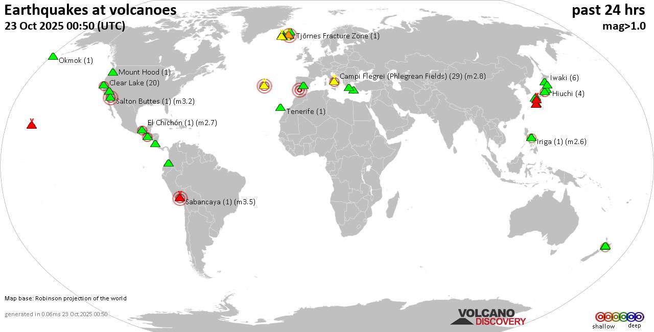
World map showing volcanoes with shallow (less than 50 km) earthquakes within 20 km radius during the past 24 hours on 23 Oct 2025 Number in brackets indicate nr of quakes.

Quakes detected near: Abu (10 quakes between mag 0.1-1.1), Bandai (1 quake mag 1.3), Brennisteinsfjöll (3 quakes between mag 0.5-2.3), Campi Flegrei (Phlegrean Fields) (19 quakes between mag 0.1-1.2), Clear Lake (14 quakes between mag 0.1-1.6), Colli Albani (1 quake mag 2.0)
Coso (1 quake mag 1.5), Cuernos de Negros (2 quakes between mag 3.0-3.0), El Chichón (16 quakes between mag 1.9-3.3), Eyafjallajökull (1 quake mag 1.3), Galeras (1 quake mag 3.0), Hakone (2 quakes between mag 0.7-1.1), Ibusuku (1 quake mag 2.2), Katla (4 quakes between mag 0.6-1.1), Kenger (3 quakes between mag 0.9-1.2), Kilauea (4 quakes between mag 1.5-1.7), Kolumbo (3 quakes between mag 1.5-2.0), Komaga-take (1 quake mag 1.0), Koruhüyüğü (1 quake mag 1.8), Krísuvík (26 quakes between mag 0.1-1.8), Kuchinoshima (2 quakes between mag 2.1-2.5), Kurikoma (3 quakes between mag 0.5-1.0), Kuwae (1 quake mag 1.7), Laguna Aramuaca (2 quakes between mag 1.4-2.0), Morne Plat Pays (1 quake mag 1.6), Nila (1 quake mag 3.7), Poas (2 quakes between mag 1.5-2.1), Prestahnukur (1 quake mag 1.4), Salton Buttes (1 quake mag 3.0), Sandal (2 quakes between mag 1.1-1.2), Sarik-Gajah (2 quakes

Click this link to continue reading the article on the source website.
RSS feed source: US National Weather Service

<!–div style="font-size:14px;text-align:center;border:3px solid blue;border-radius:5px;padding:3px;margin:5px;background:#eee"><a href="https://www.volcanoesandearthquakes.com/app/volcano-report.php?volcanoId=26" style="text-decoration:none" target="_blank" rel="noopener noreferrer nofollow" title="Share a volcano (activity) report, submit a photo or other interesting news!” onclick=”window.open(this.href,’Volcano Report’,’status=0,toolbar=0,location=0,directories=0,menubar=0,resizable=1,scrollbars=1,height=500,width=450′);return false”>Send Volcano Report</div–> Stratovolcano 3,763 m / 12,346 ft
Guatemala, 14.47°N / -90.88°W
Current status: erupting (4 out of 5) Fuego volcano eruptions:
1581, 1585, 1586, 1587, 1614, 1617, 1620, 1623, 1629, 1679(?), 1685, 1686, 1689(?), 1699, 1702, 1705, 1706, 1709(?), 1710,1717,1730, 1732, 1737, 1751(?), 1765(?), 1773(?), 1799, 1826, 1829, 1850(?), 1852(?), 1855, 1856, 1857, 1860, 1861(?), 1867(?), 1880, 1896, 1932, 1944, 1949, 1953, 1955, 1957, 1962, 1963, 1966, 1967, 1971, 1973, 1974, 1975, 1977, 1987, 1999, 2002 – ongoing
Typical eruption style
Dominantly explosive, construction of lava domes and extrusion of viscous lava flows. In near constant activity, at least during the past centuries.

Click this link to continue reading the article on the source website.