RSS feed source: US National Weather Service

…RAIN WILL TRANSITION TO SNOW TUESDAY AFTERNOON AND EVENING, WITH ACCUMULATING SNOW FALLING THROUGH WEDNESDAY MORNING. GUSTY WINDS ALONGSIDE FALLING SNOW WILL LEAD TO REDUCED VISIBILITY DUE TO BLOWING SNOW… .A potent upper level wave will move across the area on Tuesday, with initial rain becoming snow as the lower atmosphere cools underneath strengthening forcing for ascent. Rain early on will transition to snow generally from west to east as the atmosphere cools, becoming all snow by Tuesday evening. Snow rates could exceed 0.5 inches per hour at times leading to quick accumulations favoring central Minnesota. Winds will increase as the system moves through, with gusts as high as 35-40mph late

Click this link to continue reading the article on the source website.

RSS feed source: US National Weather Service

Support Us – Help Us Enhance Our Services! We’re passionate about delivering the latest volcano and earthquake data from around the globe — just for you. However, maintaining our website and free apps requires significant time, effort, and resources.
Your support helps us expand our hardware and software capabilities and empowers our dedicated editorial team. Our mission is to provide uninterrupted, real-time updates whenever an earthquake strikes or a volcano erupts — and your donations make this possible. Every contribution, big or small, is deeply appreciated. If you find our information valuable and want to help us add new features, create compelling content, and improve our technology, please consider making a donation: Donate with PayPal: Planned Features: Improved multilingual support Tsunami alerts Faster responsiveness Thanks to your past donations, we have recently added: Design upgrades Detailed earthquake

Click this link to continue reading the article on the source website.

RSS feed source: US National Weather Service

Date and TimeMag
DepthDistanceLocationDetailsMap Aug 23, 09:20 am (Port-au-Prince)

4.0

24 km68 km (42 mi) to the E North Atlantic Ocean, 36 km northwest of Port-de-Paix, Nord-Ouest, Haiti 1 reportInfoDec 6, 2024 01:42 pm (Port-au-Prince)

4.0

10 km44 km (27 mi) to the S 27 km WSW of Bombardopolis, Haiti InfoJul 28, 2023 12:09 am (Havana)

4.0

0 km85 km (53 mi) to the W 28 km south of Baracoa, Provincia de Guantanamo, Cuba InfoFeb 16, 2023 01:50 am (GMT -5)

5.4

10 km44 km (27 mi) to the S 37 km WSW of Bombardopolis, Haiti 47 reportsInfoMay 29, 2022 10:26 am (Port-au-Prince)

4.4

4 km94 km (58 mi) to the E Haiti Region InfoFeb 23, 2022 11:17 pm (Port-au-Prince)

4.1

10 km22 km (14 mi) to the E North Atlantic Ocean, 70 km west of Port-de-Paix, Nord-Ouest, Haiti InfoJan 24, 2022 03:52 pm (Port-au-Prince)

4.3

5 km78 km (48 mi) to the E Haiti Region InfoJan 23, 2022 07:06 am (Port-au-Prince)

4.3

10 km71 km (44 mi) to the E 14 km N of Anse Rouge, Haiti 4 reportsInfoAug 14, 2021 08:29 am (Port-au-Prince)

7.2

10 km175 km (109 mi) to the S Departement de Nippes, 39 km northeast of Les Cayes, Sud, Haiti 576 reportsInfoApr 29, 2020 06:22 am (Havana)

4.5

10 km51 km (32 mi) to the NW 8.6 km south of Maisí, Maisi, Guantanamo, Cuba 3 reportsInfoAug 4, 2019 07:34 pm (GMT -5)

4.3

10 km71 km (44 mi) to the SW Caribbean Sea, 77 km south of Maisi, Provincia de Guantanamo, Cuba InfoOct 16, 2018 10:05 pm (Port-au-Prince)

4.4

13 km76 km (47 mi) to the E North Atlantic Ocean, 20 km west of Ile de la Tortue

Click this link to continue reading the article on the source website.

RSS feed source: US National Weather Service

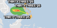
From 24/11/2025 to 24/11/2025, a Tropical Depression (maximum wind speed of 120 km/h) THIRTYTHREE-25 was active in NWPacific. The cyclone affects these countries: Philippines (vulnerability Medium). Estimated population affected by category 1 (120 km/h) wind speeds or higher is 0 (2.031 million in tropical storm).

Click this link to continue reading the article on the source website.