RSS feed source: Volcano Discovery.com--Global earthquake monitor

Tuesday, Nov 11, 2025 13:50 | 21 mins ago | By: EarthquakeMonitor

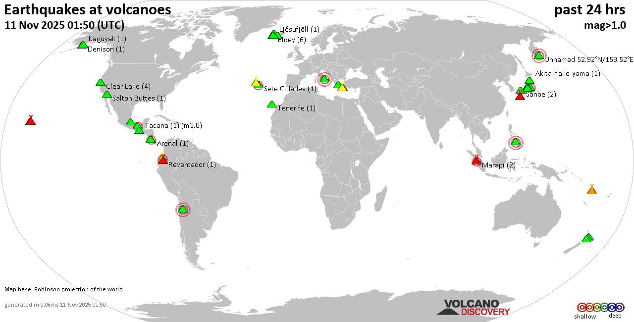
World map showing volcanoes with shallow (less than 50 km) earthquakes within 20 km radius during the past 24 hours on 11 Nov 2025 Number in brackets indicate nr of quakes.

Quakes detected near: Akagi (3 quakes between mag 0.2-1.1), Akita-Komagatake (1 quake mag 1.8), Akita-Yake-yama (2 quakes between mag 1.8-1.8), Akuseki-jima (1 quake mag 1.7), Aoba (1 quake mag 1.7), Askja (4 quakes between mag 0.6-1.0)
Clear Lake (15 quakes between mag 0.7-1.7), Cleveland (1 quake mag 1.6), Conchagüita (1 quake mag 3.0), Cuernos de Negros (1 quake mag 3.0), El Chichón (7 quakes between mag 1.7-2.6), Eldey (7 quakes between mag 0.5-2.3), Hakone (1 quake mag 1.0), Isluga (2 quakes between mag 2.9-4.0), Kialagvik (1 quake mag 2.5), Kilauea (1 quake mag 1.7), Kirishima (7 quakes between mag 0.3-1.2), Kolumbo (15 quakes between mag 1.1-2.4), Krísuvík (24 quakes between mag 0.3-1.9), Kurikoma (2 quakes between mag 0.5-1.0), Ljósufjöll (1 quake mag 1.6), Marapi (2 quakes between mag 2.2-2.3), Markagunt Plateau (1 quake mag 3.0), Maunaloa (1 quake mag 1.6), Midagahara (3 quakes between mag 0.4-1.6), Mt Fuji (2 quakes between mag 1.3-1.4), Nejapa-Miraflores (1 quake mag 3.0), Ontake-san (2 quakes between mag 0.6-1.0), Reporoa (1 quake mag 1.3), Ruapehu (3 quakes between mag 0.5-1.3), San Salvador (1 quake mag

Click this link to continue reading the article on the source website.
RSS feed source: Volcano Discovery.com--Global earthquake monitor

Date and TimeMag
DepthDistanceLocationDetailsMap Oct 30, 08:10 pm (Mexico City)

4.0

45 km49 km (30 mi) to the NE 34 km northeast of Acapulco de Juárez, Estado de Guerrero, Mexico InfoOct 28, 11:04 pm (Mexico City)

4.0

49 km43 km (27 mi) to the NE 35 km north of Acapulco de Juárez, Estado de Guerrero, Mexico InfoOct 25, 01:48 am (Mexico City)

4.0

2 km85 km (53 mi) to the NE 20 km south of Chilpancingo, Estado de Guerrero, Mexico InfoOct 23, 01:31 pm (Mexico City)

4.2

40 km48 km (30 mi) to the NE Guerrero, Mexico InfoOct 21, 03:21 am (Mazatlan)

4.0

8 km44 km (28 mi) to the W North Pacific Ocean, 36 km south of Atoyac de Alvarez, Mexico InfoDec 11, 2022 08:31 am (Mexico City)

6.0

14 km67 km (42 mi) to the NW Mexico: 22 Km Al SUR De TECPAN, GRO 88 reportsInfoSep 7, 2021 08:47 pm (Mexico City)

7.1

10 km18 km (11 mi) to the E North Pacific Ocean, 8 km south of Acapulco de Juárez, Mexico 405 reportsInfoFeb 16, 2018 05:39 pm (Mexico City)

7.2

22 km230 km (143 mi) to the E 9.4 km northeast of Pinotepa Nacional, Estado de Oaxaca, Mexico 276 reportsInfoSep 19, 2017 12:14 pm (Mexico City)

7.0

56 km257 km (159 mi) to the NE Central Mexico 345 reportsInfoMay 10, 2014 01:36 am (Mexico City)

6.0

23 km88 km (55 mi) to the NW 6 km W of Nuxco, Mexico 24 reportsInfoMay 8, 2014 11:00 am (Mexico City)

6.4

17 km83 km (52 mi) to the NW 3 km NNE of Nuxco, Mexico 40 reportsInfoApr 18, 2014 08:27 am (Mexico City)

7.2

24 km113 km (70 mi) to the NW

Click this link to continue reading the article on the source website.

RSS feed source: Volcano Discovery.com--Global earthquake monitor

…HIGH SURF ADVISORY REMAINS IN EFFECT UNTIL 6 PM THIS EVENING FOR EXPOSED NORTH AND EAST FACING SHORES… .Strong trades near and upstream of the islands will produce large and rough surf along north and east shores today. The primary swell direction will shift from north northeast (020-030) to the northeast (030-050) by this evening. This will allow north shore surf to decline, but large surf will persist along east facing shores through at least Wednesday night. * WHAT…Along north facing shores, surf of 12 to 18 feet this morning, decreasing to 10 to 15 feet by this afternoon. Along east facing shores, surf of 8 to 12 feet this morning,

Click this link to continue reading the article on the source website.

RSS feed source: Volcano Discovery.com--Global earthquake monitor

A couple of heavier snow showers are moving through eastern OH and western PA this morning. These snow showers can bring reduced visibility, down to 1/2 mile in spots, that could be hazardous to motorists. Light accumulations are possible on roadways under the heaviest snow showers and could impact portions of I-76, I-79 and I-376 over the next couple of hours.

Click this link to continue reading the article on the source website.