RSS feed source: US National Weather Service

* WHAT…Flash flooding caused by excessive rainfall continues to be possible. * WHERE…Portions of Idaho, including the following areas, Boise Mountains, Camas Prairie, Lower Treasure Valley, Owyhee Mountains, Southern Twin Falls County, Southwest Highlands, Upper Treasure Valley, Upper Weiser River, West Central Mountains and Western Magic Valley and Oregon, including the following areas, Baker County, Malheur County and Oregon Lower Treasure Valley. * WHEN…Through this evening. * IMPACTS…Heavy rainfall could trigger flash flooding or debris flows in and near recent wildfire burn scars. * ADDITIONAL DETAILS… – https://www.weather.gov/safety/flood

Click this link to continue reading the article on the source website.

RSS feed source: US National Weather Service

Date and TimeMag
DepthDistanceLocationDetailsMap May 18, 06:03 pm (Irkutsk)

3.8

10 km18 km (11 mi) to the S Lake Baykal Region, Russia

Info

Apr 15, 12:25 am (Irkutsk)

3.5

10 km68 km (42 mi) to the NE 13 km north of Babushkin, Respublika Buryatiya, Russia

Info

Nov 16, 2024 09:43 am (Irkutsk)

4.0

10 km81 km (50 mi) to the W Slyudyanskiy Rayon, 11 km east of Baykal’sk, Slyudyansky District, Irkutsk Oblast, Russia InfoJun 30, 2024 04:11 am (Irkutsk)

4.1

10 km65 km (41 mi) to the S Dzhidinskiy Rayon, 67 km northwest of Kyakhta, Kyakhtinsky District, Respublika Buryatiya, Russia 1 reportInfoJun 30, 2024 03:54 am (Irkutsk)

3.7

10 km65 km (40 mi) to the S Dzhidinskiy Rayon, 20 km northeast of Petropavlovka, Respublika Buryatiya, Russia 1 report

Info

Jun 9, 2024 07:04 pm (Irkutsk)

4.0

10 km67 km (42 mi) to the NE 78 km northwest of Gusinoozyorsk, Selenginsky District, Respublika Buryatiya, Russia InfoFeb 16, 2023 10:35 am (Irkutsk)

4.1

10 km68 km (42 mi) to the N 85 km southeast of Irkutsk, Irkutskiy Rayon, Irkutsk Oblast, Russia 9 reportsInfoNov 11, 2022 03:25 pm (Irkutsk)

4.4

10 km51 km (32 mi) to the NE Kabanskiy Rayon, 69 km northwest of Gusinoozyorsk, Selenginsky District, Respublika Buryatiya, Russia 48 reportsInfoOct 25, 2022 10:25 am (Irkutsk)

4.5

10 km65 km (40 mi) to the NW 71 km southeast of Irkutsk, Irkutskiy Rayon, Irkutsk Oblast, Russia InfoOct 14, 2022 08:53 am (Irkutsk)

4.9

10 km85 km (53 mi) to the N 100 km east of Irkutsk, Irkutskiy Rayon, Irkutsk Oblast, Russia 231 reportsInfoJun 8, 2022 08:24 pm (Irkutsk)

5.2

10 km86 km (53 mi) to the N 99 km east of Irkutsk, Irkutskiy Rayon, Irkutsk

Click this link to continue reading the article on the source website.
RSS feed source: US National Weather Service

Date and TimeMag
DepthDistanceLocationDetailsMap Jul 1, 08:39 pm (GMT -5)

5.6

36 km50 km (31 mi) to the NW South Pacific Ocean, 87 km west of San Antonio, San Antonio, Region de Valparaiso, Chile 2 reportsInfoMay 11, 02:43 am (Santiago)

4.3

60 km57 km (35 mi) to the E 24 km Al O De Melipilla 64 reportsInfoMay 4, 11:56 am (GMT -4)

4.8

41 km50 km (31 mi) to the NW South Pacific Ocean, 76 km southwest of Valparaiso, Valparaiso, Region de Valparaiso, Chile 4 reportsInfoMay 4, 10:25 am (GMT -4)

4.3

35 km51 km (32 mi) to the NW South Pacific Ocean, 77 km southwest of Valparaiso, Valparaiso, Region de Valparaiso, Chile InfoApr 5, 07:22 am (GMT -4)

4.3

25 km8.6 km (5.3 mi) to the N South Pacific Ocean, 48 km southwest of San Antonio, San Antonio, Region de Valparaiso, Chile 1 reportInfoAug 1, 2019 02:28 pm (Santiago)

6.6

10 km41 km (25 mi) to the S South Pacific Ocean, Region del Libertador General Bernardo O’Higgins, 85 km southwest of San Antonio, San Antonio, Region de Valparaiso, Chile 252 reportsInfoOct 27, 2016 04:32 pm (GMT -4)

5.8

10 km28 km (17 mi) to the NW South Pacific Ocean, 69 km west of San Antonio, San Antonio, Region de Valparaiso, Chile 2 reportsInfoSep 16, 2015 06:54 pm (Santiago)

8.2

23 km263 km (164 mi) to the N 40 km west of Illapel, Provincia de Choapa, Region de Coquimbo, Chile 103 reportsInfoNov 21, 2012 05:36 pm (Santiago)

5.9

18 km20 km (12 mi) to the SE South Pacific Ocean, Region del Libertador General Bernardo O’Higgins, 45 km southwest

Click this link to continue reading the article on the source website.

RSS feed source: US National Weather Service

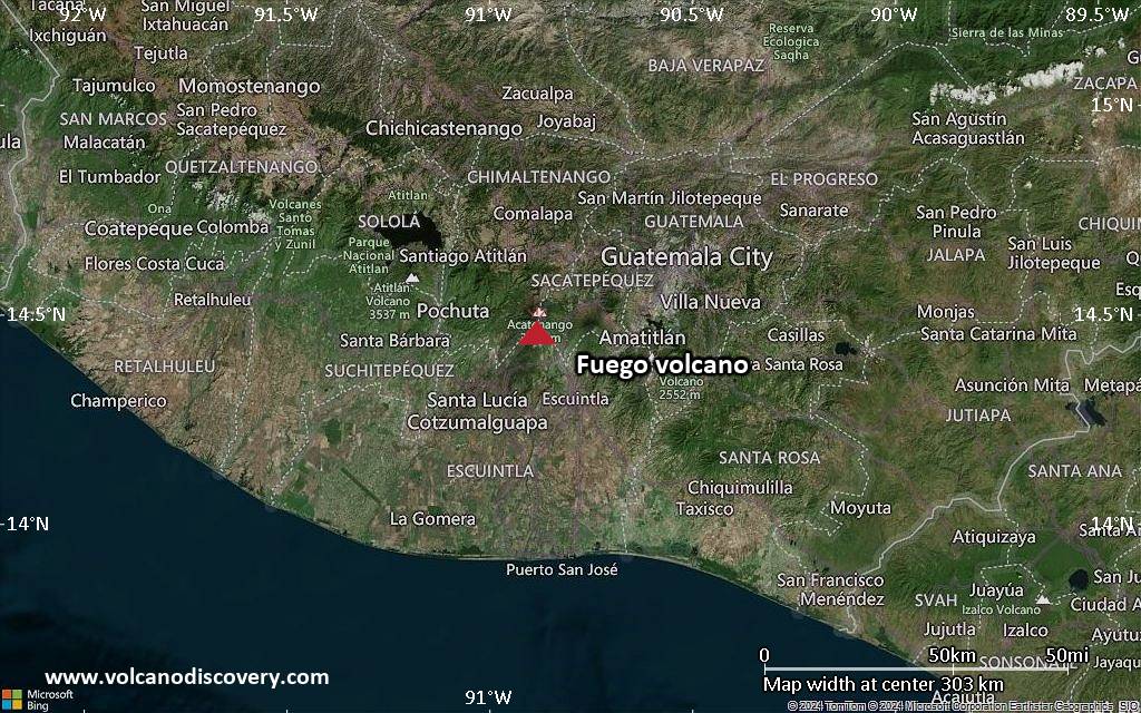
<!–div style="font-size:14px;text-align:center;border:3px solid blue;border-radius:5px;padding:3px;margin:5px;background:#eee"><a href="https://www.volcanoesandearthquakes.com/app/volcano-report.php?volcanoId=26" style="text-decoration:none" target="_blank" rel="noopener noreferrer nofollow" title="Share a volcano (activity) report, submit a photo or other interesting news!” onclick=”window.open(this.href,’Volcano Report’,’status=0,toolbar=0,location=0,directories=0,menubar=0,resizable=1,scrollbars=1,height=500,width=450′);return false”>Send Volcano Report</div–> Stratovolcano 3,763 m / 12,346 ft
Guatemala, 14.47°N / -90.88°W
Current status: erupting (4 out of 5) Fuego volcano eruptions:
1581, 1585, 1586, 1587, 1614, 1617, 1620, 1623, 1629, 1679(?), 1685, 1686, 1689(?), 1699, 1702, 1705, 1706, 1709(?), 1710,1717,1730, 1732, 1737, 1751(?), 1765(?), 1773(?), 1799, 1826, 1829, 1850(?), 1852(?), 1855, 1856, 1857, 1860, 1861(?), 1867(?), 1880, 1896, 1932, 1944, 1949, 1953, 1955, 1957, 1962, 1963, 1966, 1967, 1971, 1973, 1974, 1975, 1977, 1987, 1999, 2002 – ongoing
Typical eruption style
Dominantly explosive, construction of lava domes and extrusion of viscous lava flows. In near constant activity, at least during the past centuries.

Click this link to continue reading the article on the source website.