RSS feed source: Volcano Discovery.com--Global earthquake monitor

Date and TimeMag
DepthDistanceLocationDetailsMap Nov 3, 2023 11:17 am (GMT +12)

4.1

518 km94 km (59 mi) to the WSouth Pacific Ocean, 106 km southeast of Wakaya Island, Eastern, Fiji InfoJun 7, 2023 06:48 am (Fiji)

4.3

542 km164 km (102 mi) to the WSouth Pacific Ocean, 49 km south of Wakaya Island, Eastern, Fiji InfoMar 22, 2022 02:31 am (GMT +12)

4.1

549 km207 km (128 mi) to the W47 km SSE of Suva, Fiji InfoDec 15, 2021 02:12 am (Fiji)

4.3

544 km150 km (93 mi) to the WSouth Pacific Ocean, 46 km southeast of Wakaya Island, Eastern, Fiji InfoJan 29, 2021 02:58 am (Fiji)

4.3

555 km159 km (99 mi) to the W South Pacific Ocean, 49 km south of Wakaya Island, Eastern, Fiji InfoSep 16, 2019 02:03 am (Fiji)

4.5

645 km117 km (72 mi) to the WSouth Pacific Ocean, 61 km southeast of Wakaya Island, Eastern, Fiji InfoSep 29, 2018 07:38 am (Fiji)

4.5

656 km120 km (75 mi) to the SW South Pacific Ocean, 77 km southeast of Levuka, Eastern, Fiji InfoSep 7, 2018 11:40 am (Fiji)

4.5

639 km146 km (91 mi) to the W South Pacific Ocean, 68 km south of Wakaya Island, Eastern, Fiji InfoSep 7, 2018 06:22 am (GMT +12)

5.0

662 km159 km (99 mi) to the SW South Pacific Ocean, 151 km southeast of Suva, Central, Fiji InfoSep 7, 2018 06:13 am (GMT +12)

4.6

649 km166 km (103 mi) to the W South Pacific Ocean, 32 km west of Levuka, Eastern, Fiji InfoSep 7, 2018 04:15 am (Fiji)

4.9

599 km86 km (53 mi) to the W South Pacific Ocean, 111 km southeast of Wakaya

Click this link to continue reading the article on the source website.

RSS feed source: Volcano Discovery.com--Global earthquake monitor

* WHAT…Temperatures as low as 34 will result in frost formation. * WHERE…Trinity County, and Northeastern Mendocino Interior. * WHEN…From 2 AM to 9 AM PDT Tuesday. * IMPACTS…Frost could harm sensitive outdoor vegetation. Sensitive outdoor plants may be killed if left uncovered.

Click this link to continue reading the article on the source website.

RSS feed source: Volcano Discovery.com--Global earthquake monitor

* WHAT…Temperatures as low as 31 will result in frost formation. * WHERE…Del Norte and Northern Humboldt Coast. * WHEN…Until 9 AM PDT this morning. * IMPACTS…Frost could harm sensitive outdoor vegetation. Sensitive outdoor plants may be killed if left uncovered. * ADDITIONAL DETAILS…Areas closest to the ocean will not see frost.

Click this link to continue reading the article on the source website.
RSS feed source: Volcano Discovery.com--Global earthquake monitor

Mon, 27 Oct 2025, 11:50 | BY: EARTHQUAKEMONITOR

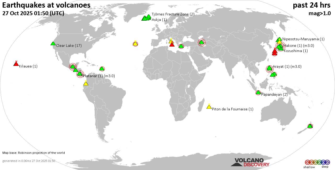
World map showing volcanoes with shallow (less than 50 km) earthquakes within 20 km radius during the past 24 hours on 27 Oct 2025 Number in brackets indicate nr of quakes.

Quakes detected near: Akuseki-jima (1 quake mag 1.9), Apaneca Range (2 quakes between mag 1.8-2.1), Bardarbunga (8 quakes between mag 0.5-1.9), Brennisteinsfjöll (3 quakes between mag 0.2-1.9), Buzzard Creek (1 quake mag 2.0), Cabalian (1 quake mag 2.8)
Campi Flegrei (Phlegrean Fields) (26 quakes between mag 0.1-1.4), Cerro Negro de Mayasquer (1 quake mag 1.9), Cerro Singüil (1 quake mag 2.3), Clear Lake (20 quakes between mag 0.2-1.6), Cuernos de Negros (1 quake mag 3.0), El Chichón (21 quakes between mag 1.8-3.4), Etna (1 quake mag 1.6), Grímsvötn (2 quakes between mag 0.8-1.4), Ibusuku (2 quakes between mag 0.8-1.1), Izalco (1 quake mag 1.8), Katla (2 quakes between mag 0.9-1.1), Kilauea (1 quake mag 1.8), Kirishima (4 quakes between mag 0.4-1.0), Kolumbo (1 quake mag 2.6), Komaga-take (2 quakes between mag 0.4-1.7), Kozushima (1 quake mag 1.3), Krísuvík (9 quakes between mag 0.0-1.0), La Palma (1 quake mag 1.0), Ljósufjöll (7 quakes between mag 0.5-1.8), Lokbatan (1 quake mag 3.0), Loki-Fögrufjöll volcano (2 quakes between mag 1.3-1.6), Maunaloa (1 quake mag 2.0), Nantai (16 quakes between mag 0.1-2.4), Nipesotsu-Maruyama (1 quake mag 1.1), Papandayan (1

Click this link to continue reading the article on the source website.