RSS feed source: Volcano Discovery.com--Global earthquake monitor

Tue, 19 Aug 2025, 11:50 | BY: EARTHQUAKEMONITOR

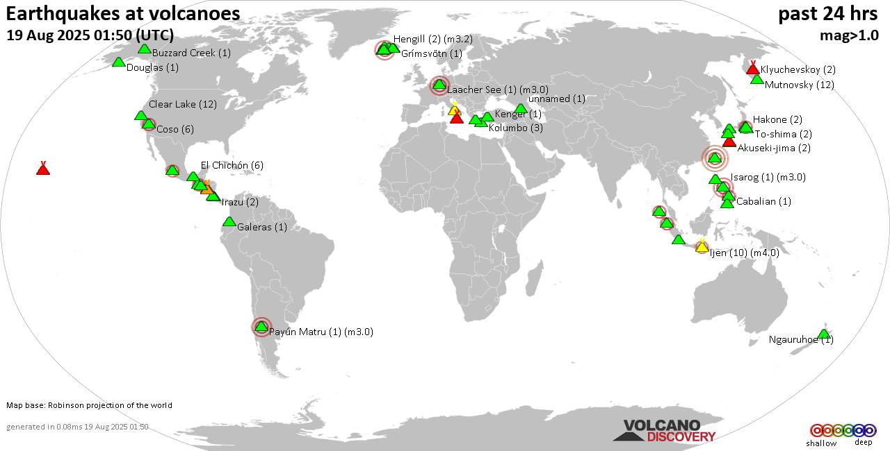
World map showing volcanoes with shallow (less than 50 km) earthquakes within 20 km radius during the past 24 hours on 19 Aug 2025 Number in brackets indicate nr of quakes.

Quakes detected near: Abu (26 quakes between mag 0.2-1.8), Agua (2 quakes between mag 2.4-2.7), Brennisteinsfjöll (27 quakes between mag 0.1-1.2), Buzzard Creek (1 quake mag 1.4), Campi Flegrei (Phlegrean Fields) (24 quakes between mag 0.1-1.3), Cerro Singüil (1 quake mag 2.9)
Clear Lake (8 quakes between mag 0.2-1.1), Douglas (1 quake mag 1.1), El Chichón (36 quakes between mag 1.5-3.0), Eldey (4 quakes between mag 0.9-1.4), Galeras (1 quake mag 1.0), Geureudong (1 quake mag 2.1), Hakone (2 quakes between mag 0.1-2.5), Hengill (2 quakes between mag 1.3-3.2), Hiuchi (4 quakes between mag 0.4-1.4), Hrómundartindur (12 quakes between mag 0.0-1.4), Ijen (3 quakes between mag 2.4-3.4), Irazu (1 quake mag 1.9), Isarog (1 quake mag 3.0), Kilauea (3 quakes between mag 1.7-2.3), Klabat (1 quake mag 3.0), Klyuchevskoy (3 quakes between mag 1.2-1.3), Kolumbo (6 quakes between mag 1.3-2.4), Krísuvík (13 quakes between mag 0.0-1.6), Laacher See (1 quake mag 3.0), Langjökull (1 quake mag 1.6), Ljósufjöll (12 quakes between mag 0.3-2.5), Loki-Fögrufjöll volcano (3 quakes between mag 0.5-1.0), Mandalagan (1 quake mag 1.8), Maunaloa (1 quake mag 2.7), Michoacán-Guanajuato (2 quakes between mag

Click this link to continue reading the article on the source website.
RSS feed source: Volcano Discovery.com--Global earthquake monitor

…The National Weather Service in La Crosse WI has issued a Flood Warning for the following rivers in Iowa… Turkey River at Elkader affecting Clayton County. * WHAT…Minor flooding is forecast. * WHERE…Turkey River at Elkader. * WHEN…From this afternoon to late Thursday evening. * ADDITIONAL DETAILS… – At 5:45 AM CDT Tuesday the stage was 8.9 feet. – Bankfull stage is 12.0 feet. – Forecast…The river is expected to rise above flood stage late this afternoon to a crest of 14.3 feet tomorrow morning. It will then fall below flood stage late Thursday morning. – Flood stage is 12.0 feet. – http://www.weather.gov/safety/flood

Click this link to continue reading the article on the source website.

RSS feed source: Volcano Discovery.com--Global earthquake monitor

* WHAT…Flooding caused by excessive rainfall continues. * WHERE…A portion of northeast Iowa, including the following counties, Chickasaw and Howard. * WHEN…Until 1100 AM CDT. * IMPACTS…Flooding of rivers, creeks, streams, and other low-lying and flood-prone locations is imminent or occurring. Numerous roads remain closed due to flooding. * ADDITIONAL DETAILS… – At 640 AM CDT, Local law enforcement reported flooding in the warned area. Flooding is already occurring. Between 3 and 6 inches of rain have fallen. – Flooding impacts will continue, but no additional rainfall is expected. – Some locations that will experience flooding include… Cresco, New Hampton, Elma, Lawler, Ionia, Protivin, Jerico, Chickasaw, Alta Vista, North Washington, Bassett,

Click this link to continue reading the article on the source website.

RSS feed source: Volcano Discovery.com--Global earthquake monitor

FFWAKQ The National Weather Service in Wakefield has issued a * Flash Flood Warning for… South Central Accomack County in southeastern Virginia… * Until 1045 AM EDT. * At 739 AM EDT, emergency management reported a couple of cars in high water due to the heavy rain in Accomack. Up to 4 inches of rain have fallen. Additional rainfall amounts of 0.5 to 1.5 inches are possible in the warned area. Flash flooding is already occurring. HAZARD…Flash flooding caused by thunderstorms. SOURCE…Emergency management reported. IMPACT…Flash flooding of small creeks and streams, urban areas, highways, streets and underpasses as well as other poor drainage and low-lying areas. * Some locations that will

Click this link to continue reading the article on the source website.