RSS feed source: US National Weather Service

* WHAT…West winds 30 to 40 mph with gusts up to 65 mph possible. * WHERE…Bordeaux area along Interstate 25 between Chugwater and Wheatland. * WHEN…From 6 AM to 6 PM MDT Monday. * IMPACTS…Mainly to transportation. Strong cross winds will be hazardous to light weight or high profile vehicles, including campers and tractor trailers.

Click this link to continue reading the article on the source website.

RSS feed source: US National Weather Service

FFWMLB The National Weather Service in Melbourne has issued a * Flash Flood Warning for… Central Lake County in east central Florida… * Until 100 AM EDT. * At 957 PM EDT, Doppler radar indicated thunderstorms producing heavy rain across the warned area. Between 15 and 18 inches of rain have fallen. Additional rainfall amounts of 2 to 3 inches are possible in the warned area. Flash flooding is ongoing or expected to begin shortly. This is a FLASH FLOOD EMERGENCY for Eustis and Mount Dora. This is a PARTICULARLY DANGEROUS SITUATION. SEEK HIGHER GROUND NOW! HAZARD…Life threatening flash flooding. Thunderstorms producing flash flooding. SOURCE…Radar. IMPACT…This is a PARTICULARLY DANGEROUS SITUATION.

Click this link to continue reading the article on the source website.
RSS feed source: US National Weather Service

FFWMLB The National Weather Service in Melbourne has issued a * Flash Flood Warning for… Northeastern Brevard County in east central Florida… * Until 1145 PM EDT. * At 952 PM EDT, local law enforcement reported thunderstorms producing heavy rain across the warned area. Between 7 and 12 inches of rain have fallen. Additional rainfall amounts of 2 to 3 inches are possible in the warned area. Flash flooding is already occurring. HAZARD…Life threatening flash flooding. Thunderstorms producing flash flooding. SOURCE…Law enforcement reported. IMPACT…Life threatening flash flooding of creeks and streams, urban areas, highways, streets and underpasses. * Some locations that will experience flash flooding include… Rockledge, Cocoa, Cocoa Beach, Cape

Click this link to continue reading the article on the source website.

RSS feed source: US National Weather Service

Mon, 27 Oct 2025, 01:50 | BY: EARTHQUAKEMONITOR

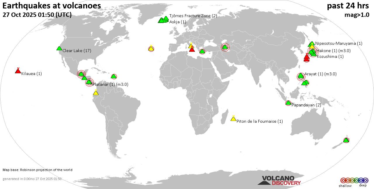
World map showing volcanoes with shallow (less than 50 km) earthquakes within 20 km radius during the past 24 hours on 27 Oct 2025 Number in brackets indicate nr of quakes.

Quakes detected near: Akagi (4 quakes between mag 0.1-4.7), Apaneca Range (2 quakes between mag 1.8-2.1), Arayat (1 quake mag 3.0), Askja (1 quake mag 1.0), Bardarbunga (9 quakes between mag 0.5-1.9), Brennisteinsfjöll (3 quakes between mag 0.9-1.2)
Cabalian (1 quake mag 2.8), Campi Flegrei (Phlegrean Fields) (38 quakes between mag 0.1-1.0), Cerro Negro de Mayasquer (1 quake mag 1.9), Clear Lake (17 quakes between mag 0.6-1.6), Cuernos de Negros (1 quake mag 3.0), El Chichón (11 quakes between mag 1.8-3.4), Eldey (2 quakes between mag 1.0-1.5), Etna (1 quake mag 1.6), Grímsnes (3 quakes between mag 0.3-1.7), Hakone (1 quake mag 3.0), Hrómundartindur (10 quakes between mag 0.4-1.0), Izalco (1 quake mag 1.8), Kilauea (1 quake mag 1.8), Kirishima (5 quakes between mag 0.5-1.3), Kolumbo (1 quake mag 2.6), Komaga-take (2 quakes between mag 0.4-1.7), Kozushima (1 quake mag 1.3), Ljósufjöll (3 quakes between mag 0.9-1.9), Lokbatan (1 quake mag 3.0), Loki-Fögrufjöll volcano (1 quake mag 1.8), Maunaloa (1 quake mag 2.0), Morne Plat Pays (1 quake mag 2.4), Nantai (76 quakes between mag 0.1-3.7), Ngauruhoe (1 quake mag 2.1), Nipesotsu-Maruyama (1 quake mag

Click this link to continue reading the article on the source website.