RSS feed source: USGS Earthquake Hazards Program
Time2025-12-11 17:18:34 UTC2025-12-11 17:18:34 UTC at epicenterLocation12.860°N 89.900°WDepth43.28 km (26.90 mi)
Click this link to continue reading the article on the source website.
RSS feed source: USGS Earthquake Hazards Program
Time2025-12-11 17:18:34 UTC2025-12-11 17:18:34 UTC at epicenterLocation12.860°N 89.900°WDepth43.28 km (26.90 mi)
Click this link to continue reading the article on the source website.
RSS feed source: USGS Earthquake Hazards Program
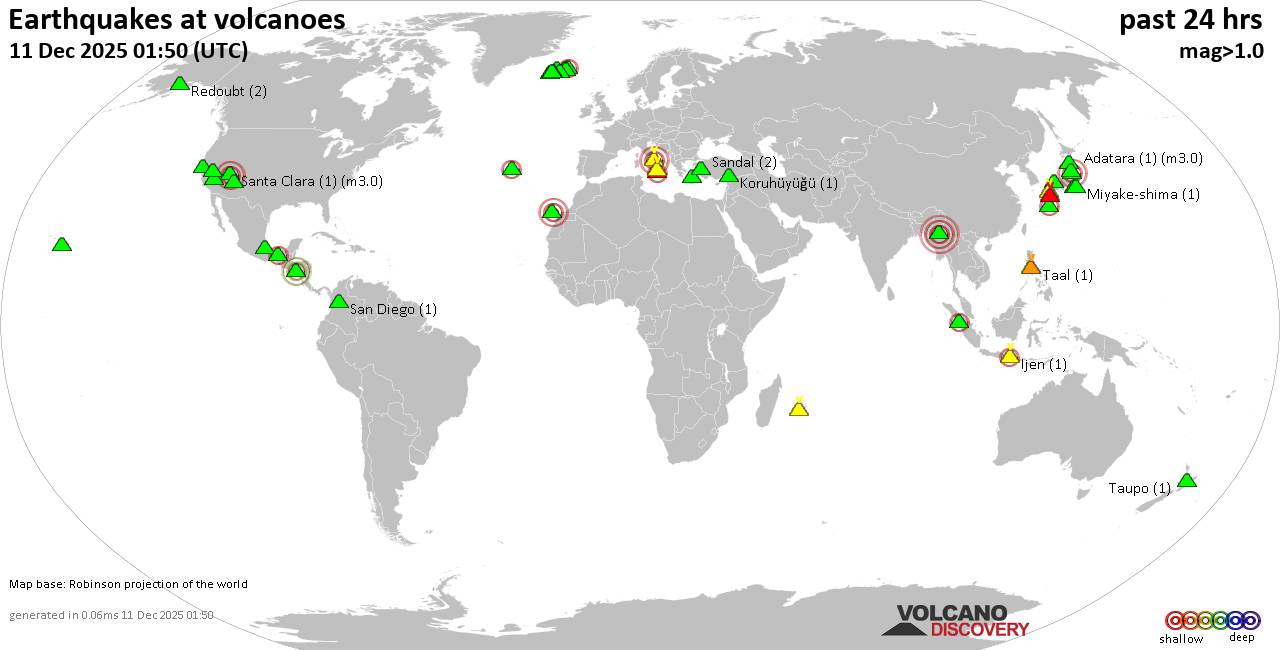
Thursday, Dec 11, 2025 17:50 | 42 mins ago | By: EarthquakeMonitor
World map showing volcanoes with shallow (less than 50 km) earthquakes within 20 km radius during the past 24 hours on 11 Dec 2025 Number in brackets indicate nr of quakes.
Quakes detected near: Akuseki-jima (7 quakes between mag 0.9-2.2), Apaneca Range (1 quake mag 1.8), Aso (23 quakes between mag 0.1-1.6), Augustine (1 quake mag 1.7), Baluran (1 quake mag 2.5), Bandai (1 quake mag 1.1)
Campi Flegrei (Phlegrean Fields) (12 quakes between mag 0.1-3.0), Clear Lake (23 quakes between mag 0.2-2.0), Cuernos de Negros (1 quake mag 3.0), Dieng (1 quake mag 2.3), El Chichón (7 quakes between mag 2.1-3.4), Eldey (4 quakes between mag 0.9-2.2), Esjufjöll (2 quakes between mag 1.3-1.5), Fourpeaked (2 quakes between mag 1.7-1.9), Geureudong (1 quake mag 3.1), Gran Canaria (1 quake mag 3.0), Hekla (1 quake mag 1.2), Hiuchi (1 quake mag 1.2), Hofsjökull (1 quake mag 2.0), Hualalai (1 quake mag 2.1), Ijen (2 quakes between mag 2.2-2.2), Katla (2 quakes between mag 0.6-1.2), Kilauea (3 quakes between mag 1.8-1.9), Kirishima (2 quakes between mag 1.0-1.1), Kolumbo (1 quake mag 1.6), Kozushima (41 quakes between mag 0.9-3.3), Kuju (7 quakes between mag 0.2-1.7), Kurikoma (2 quakes between mag 0.3-1.4), La Palma (1 quake mag 1.4), Miyake-shima (1 quake mag 1.4), Nantai (6
Click this link to continue reading the article on the source website.
RSS feed source: USGS Earthquake Hazards Program
<!–div style="font-size:14px;text-align:center;border:3px solid blue;border-radius:5px;padding:3px;margin:5px;background:#eee"><a href="https://www.volcanoesandearthquakes.com/app/volcano-report.php?volcanoId=26" style="text-decoration:none" target="_blank" rel="noopener noreferrer nofollow" title="Share a volcano (activity) report, submit a photo or other interesting news!” onclick=”window.open(this.href,’Volcano Report’,’status=0,toolbar=0,location=0,directories=0,menubar=0,resizable=1,scrollbars=1,height=500,width=450′);return false”>Send Volcano Report</div–> Stratovolcano 3,763 m / 12,346 ft
Guatemala, 14.47°N / -90.88°W
Current status: erupting (4 out of 5) Fuego volcano eruptions:
1581, 1585, 1586, 1587, 1614, 1617, 1620, 1623, 1629, 1679(?), 1685, 1686, 1689(?), 1699, 1702, 1705, 1706, 1709(?), 1710,1717,1730, 1732, 1737, 1751(?), 1765(?), 1773(?), 1799, 1826, 1829, 1850(?), 1852(?), 1855, 1856, 1857, 1860, 1861(?), 1867(?), 1880, 1896, 1932, 1944, 1949, 1953, 1955, 1957, 1962, 1963, 1966, 1967, 1971, 1973, 1974, 1975, 1977, 1987, 1999, 2002 – ongoing
Typical eruption style
Dominantly explosive, construction of lava domes and extrusion of viscous lava flows. In near constant activity, at least during the past centuries.
Click this link to continue reading the article on the source website.
RSS feed source: USGS Earthquake Hazards Program
Date and TimeMag
DepthDistanceLocationDetailsMap Dec 5, 05:15 pm (Ho Chi Minh)
3.4
10 km38 km (23 mi) to the NW 87 km southwest of Tam Ky, Tinh Quang Nam, Vietnam I FELT IT – 1 report
Info
Nov 8, 10:51 am (Ho Chi Minh)
3.6
10 km38 km (23 mi) to the SW 53 km northwest of Kon Tum, Kon Tum, Vietnam 1 report
Info
Nov 8, 10:28 am (Ho Chi Minh)
4.0
10 km69 km (43 mi) to the SW 35 km west of Kon Tum, Kon Tum, Vietnam InfoNov 8, 09:47 am (Ho Chi Minh)
4.8
10 km9.9 km (6.1 mi) to the NW 76 km north of Kon Tum, Kon Tum, Vietnam 1 reportInfoOct 16, 11:26 pm (Ho Chi Minh)
3.9
10 km58 km (36 mi) to the S 28 km northwest of Kon Tum, Kon Tum, Vietnam
Info
Oct 16, 04:22 pm (Ho Chi Minh)
4.6
10 km6 km (3.7 mi) to the N Tinh Quang Nam, 75 km north of Kon Tum, Kon Tum, Vietnam InfoOct 16, 04:40 am (Ho Chi Minh)
4.7
10 km6.6 km (4.1 mi) to the NW 72 km north of Kon Tum, Kon Tum, Vietnam 1 reportInfoOct 13, 01:58 am (Ho Chi Minh)
4.8
10 km35 km (22 mi) to the W 85 km northwest of Kon Tum, Kon Tum, Vietnam InfoOct 9, 05:53 am (Ho Chi Minh)
4.6
10 km34 km (21 mi) to the W 76 km northwest of Kon Tum, Kon Tum, Vietnam InfoOct 6, 11:49 am (Ho Chi Minh)
4.8
10 km22 km (14 mi) to the SW 62 km northwest of Kon Tum, Kon Tum, Vietnam InfoOct 6, 09:58 am (Ho Chi Minh)
4.7
10 km24 km
Click this link to continue reading the article on the source website.