RSS feed source: Volcano Discovery.com--Global earthquake monitor

Sunday, Nov 16, 2025 21:50 | 39 mins ago | By: EarthquakeMonitor

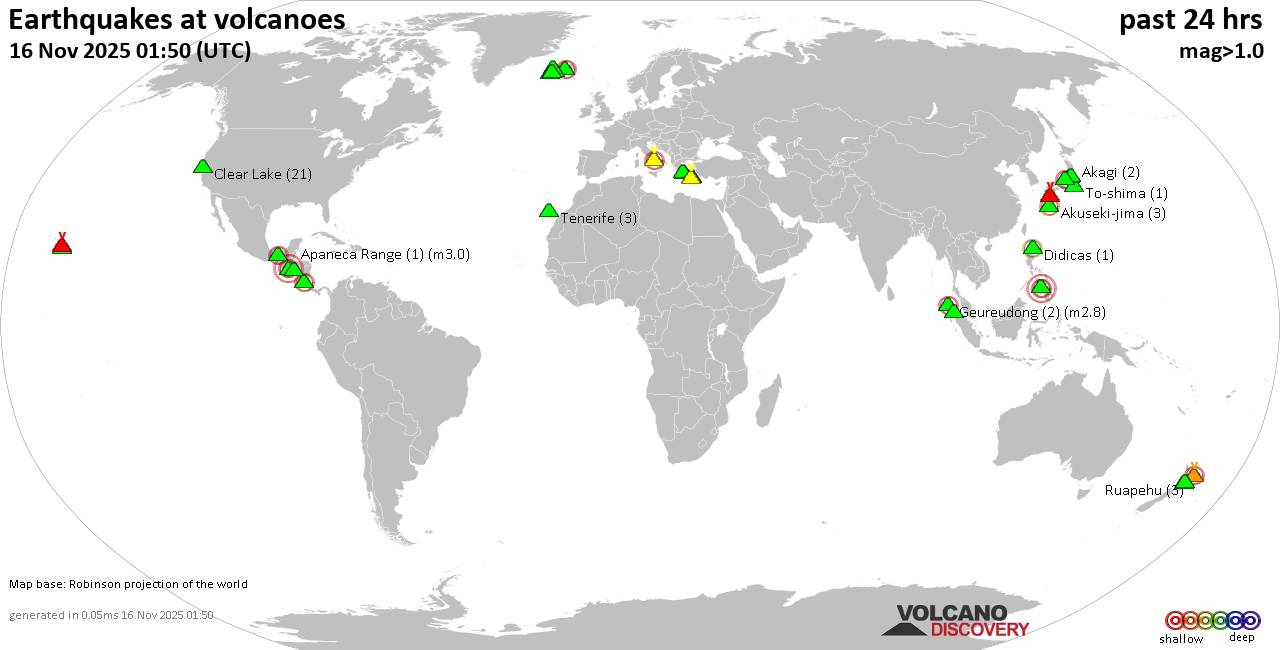
World map showing volcanoes with shallow (less than 50 km) earthquakes within 20 km radius during the past 24 hours on 16 Nov 2025 Number in brackets indicate nr of quakes.

Quakes detected near: Akuseki-jima (3 quakes between mag 1.2-1.4), Apastepeque (1 quake mag 3.0), Campi Flegrei (Phlegrean Fields) (14 quakes between mag 0.1-1.1), Clear Lake (39 quakes between mag 0.2-1.7), Conchagüita (3 quakes between mag 1.8-2.1), El Chichón (8 quakes between mag 1.9-2.8)
Eldey (2 quakes between mag 1.0-1.4), Etna (1 quake mag 1.3), Girekol (1 quake mag 1.5), Gran Canaria (2 quakes between mag 1.0-1.1), Grímsnes (4 quakes between mag 0.4-1.1), Kilauea (3 quakes between mag 1.7-1.8), Kirishima (9 quakes between mag 0.2-1.4), Kolumbo (2 quakes between mag 1.4-1.9), Krísuvík (10 quakes between mag 0.0-1.4), Ljósufjöll (6 quakes between mag 0.3-1.9), Loki-Fögrufjöll volcano (1 quake mag 2.4), Mahagnao (1 quake mag 2.7), Maroa (3 quakes between mag 1.5-1.7), Methana (2 quakes between mag 1.3-2.0), Ontake-san (3 quakes between mag 0.2-1.1), Perbakti (1 quake mag 2.4), Qal’eh Hasan Ali (1 quake mag 3.0), Ragang (1 quake mag 2.3), Ranau caldera (1 quake mag 2.6), Reporoa (11 quakes between mag 1.3-1.9), Sakurajima (4 quakes between mag 0.5-1.2), Soufrière de Guadeloupe (1 quake mag 1.5), Sousaki (1 quake mag 1.2), Suoh

Click this link to continue reading the article on the source website.
RSS feed source: Volcano Discovery.com--Global earthquake monitor

Date and TimeMag
DepthDistanceLocationDetailsMap Oct 14, 09:20 am (GMT -7)

4.8

10 km65 km (40 mi) to the NW North Pacific Ocean, 331 km south of Cabo San Lucas, Mexico 1 reportInfoOct 6, 09:28 am (GMT -7)

4.2

10 km13 km (7.8 mi) to the SW Revilla Gigedo Islands Region InfoSep 9, 10:14 pm (GMT -7)

4.4

10 km61 km (38 mi) to the SE North Pacific Ocean, 454 km southwest of Tepic, Estado de Nayarit, Mexico InfoAug 30, 08:19 pm (GMT -7)

4.0

10 km75 km (47 mi) to the SW North Pacific Ocean, 417 km southwest of Campamento Aserradero, Mexico InfoJun 28, 11:45 am (GMT -7)

4.4

10 km39 km (24 mi) to the NE North Pacific Ocean, 444 km southwest of Palmito del Verde, Mexico InfoMay 28, 02:01 am (GMT -7)

5.4

10 km46 km (28 mi) to the NW North Pacific Ocean, 211 km northeast of Isla Socorro Island, Mexico 1 reportInfoMay 27, 06:30 pm (GMT -7)

5.9

10 km21 km (13 mi) to the N North Pacific Ocean, 234 km northeast of Isla Socorro Island, Mexico 1 reportInfoMay 27, 02:59 pm (GMT -7)

5.8

10 km33 km (21 mi) to the N North Pacific Ocean, 236 km northeast of Isla Socorro Island, Mexico 3 reportsInfoMar 17, 02:50 am (GMT -7)

5.5

10 km7 km (4.4 mi) to the NE Revilla Gigedo Islands Region InfoNov 30, 2024 08:08 am (GMT -7)

5.4

10 km77 km (48 mi) to the E Mexico: 344 km al SUROESTE de PUERTO VALLARTA, JAL 1 reportInfoNov 26, 2018 10:37 pm (GMT -7)

5.5

10 km74 km (46 mi) to the E North Pacific Ocean, 430 km southwest of Tepic,

Click this link to continue reading the article on the source website.

RSS feed source: Volcano Discovery.com--Global earthquake monitor

* WHAT…Visibility as low as one quarter mile in dense fog. * WHERE…Richland and Roosevelt Counties. * WHEN…Until 6 PM MST this evening. * IMPACTS…Low visibility could make driving conditions hazardous.

Click this link to continue reading the article on the source website.