RSS feed source: US National Weather Service

* WHAT…Life-threatening rip currents. * WHERE…Beaches of northern and eastern Puerto Rico, Culebra, and Saint Croix. * WHEN…Through 6 PM AST Thursday. * IMPACTS…Rip currents can sweep even the best swimmers away from shore into deeper water, where it becomes difficult to return to safety.

Click this link to continue reading the article on the source website.

RSS feed source: US National Weather Service

Date and TimeMag
DepthDistanceLocationDetailsMap Oct 27, 09:08 am (GMT +8)

4.7

49 km99 km (61 mi) to the W Philippine Sea, 35 km east of Tandag, Philippines 2 reportsInfoOct 19, 11:05 pm (GMT +8)

4.5

52 km67 km (41 mi) to the W Philippine Sea, 66 km east of Tandag, Philippines 3 reportsInfoOct 18, 08:31 pm (GMT +8)

5.4

63 km98 km (61 mi) to the W Philippine Sea, 38 km southeast of Tandag, Philippines 53 reportsInfoOct 12, 05:44 pm (GMT +8)

4.4

26 km61 km (38 mi) to the SW Philippine Sea, 116 km southeast of Tandag, Philippines 2 reportsInfoOct 12, 02:56 pm (GMT +8)

4.7

54 km56 km (35 mi) to the SW Philippine Sea, Davao, 82 km east of Bislig, Philippines 1 reportInfoOct 10, 09:43 am (Manila)

7.4

58 km176 km (109 mi) to the S Philippine Sea, 24 km east of Manay, Philippines 451 reportsInfoMar 13, 12:09 am (GMT +9)

5.7

10 km47 km (29 mi) to the SE Philippine Sea, 142 km east of Bislig, Philippines 4 reportsInfoAug 3, 2024 12:20 pm (GMT +8)

6.3

15 km81 km (51 mi) to the SW Philippine Sea, 57 km east of Bislig, Philippines 22 reportsInfoDec 5, 2023 09:36 pm (GMT +8)

5.8

12 km78 km (49 mi) to the NW Philippine Sea, 65 km east of Tandag, Philippines 5 reportsInfoDec 5, 2023 05:10 pm (GMT +8)

5.7

20 km84 km (52 mi) to the NW Philippine Sea, 53 km east of Tandag, Philippines 6 reportsInfoDec 4, 2023 03:49 am (GMT +8)

6.9

20 km85 km (53 mi) to the W Philippine Sea, 47 km east of Tandag, Philippines 97 reportsInfoDec 3, 2023 10:35 pm (GMT

Click this link to continue reading the article on the source website.

RSS feed source: US National Weather Service

* WHAT…Visibility one quarter mile or less in dense fog. * WHERE…Anchorage. * WHEN…Until 1 PM AKST this afternoon. * IMPACTS…Hazardous driving conditions due to low visibility. Below freezing temperatures may lead to frost on bridges and roadways. * ADDITIONAL DETAILS…Visibilities are expected to improve as fog begins to erode over the next one to two hours. However, localized areas of dense fog may linger from JBER south through Midtown and South Anchorage through early afternoon.

Click this link to continue reading the article on the source website.

RSS feed source: US National Weather Service

Wednesday, Nov 19, 2025 19:50 | 42 mins ago | By: EarthquakeMonitor

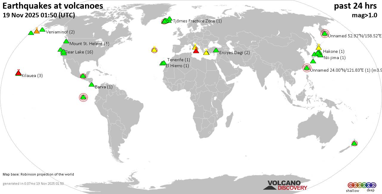
World map showing volcanoes with shallow (less than 50 km) earthquakes within 20 km radius during the past 24 hours on 19 Nov 2025 Number in brackets indicate nr of quakes.

Quakes detected near: Akita-Yake-yama (5 quakes between mag 0.2-1.1), Baluran (1 quake mag 2.7), Campi Flegrei (Phlegrean Fields) (38 quakes between mag 0.1-2.7), Clear Lake (36 quakes between mag 0.2-2.3), Cofre de Perote (3 quakes between mag 2.6-3.2), El Chichón (3 quakes between mag 2.3-2.8)
El Hierro (1 quake mag 1.9), Eldey (176 quakes between mag 0.2-2.8), Etna (1 quake mag 1.6), Hiuchi (2 quakes between mag 0.6-1.0), Irazu (1 quake mag 2.1), Katla (3 quakes between mag 0.4-1.2), Kawah Kamojang (1 quake mag 1.8), Kilauea (2 quakes between mag 1.7-1.9), Kolumbo (2 quakes between mag 1.8-2.0), Koruhüyüğü (1 quake mag 1.8), Kurikoma (6 quakes between mag 0.5-1.4), Ljósufjöll (6 quakes between mag 0.4-1.9), Martin (1 quake mag 1.3), Matutum (1 quake mag 2.7), Maunaloa (3 quakes between mag 1.4-2.0), Papandayan (7 quakes between mag 1.9-3.3), Pular (1 quake mag 3.0), Salton Buttes (1 quake mag 1.1), Santorini (1 quake mag 1.6), Taupo (1 quake mag 2.2), Tenorio (1 quake mag 1.6), Tjörnes Fracture Zone (1 quake mag 1.1), To-shima (2 quakes between mag 1.2-1.9), Yellowstone (1 quake mag 1.3)

Click this link to continue reading the article on the source website.