RSS feed source: US National Weather Service

* WHAT…Visibility one quarter mile or less in dense fog. * WHERE…Western Magic Valley, Lower Treasure Valley, and Upper Treasure Valley. * WHEN…From 11 PM this evening to 10 AM MST Saturday. * IMPACTS…Low visibility could make driving conditions hazardous.

Click this link to continue reading the article on the source website.

RSS feed source: US National Weather Service

* WHAT…Flooding caused by excessive rainfall continues to be possible. * WHERE…Portions of southwest Arizona, including the following areas, Central La Paz, Gila River Valley, Kofa, Parker Valley, Southeast Yuma County and Yuma and California, including the following areas, Chiriaco Summit, Chuckwalla Mountains, Chuckwalla Valley, Imperial County Southeast, Imperial County Southwest, Imperial County West, Imperial Valley, Joshua Tree NP East, Joshua Tree NP West, Palo Verde Valley and Salton Sea. * WHEN…Until midnight MST /11 PM PST/ tonight. * IMPACTS…Excessive runoff may result in flooding of rivers, creeks, streams, and other low-lying and flood-prone locations. Low-water crossings may be flooded. * ADDITIONAL DETAILS… – A weather system moving through the region

Click this link to continue reading the article on the source website.

RSS feed source: US National Weather Service

* WHAT…Breaking waves of 5 to 8 feet. West winds 20 to 25 mph with gusts of 30 to 35 mph. * WHERE…South side of the Homer Spit. * WHEN…Until 6 PM AKST this evening. * IMPACTS…Water and light debris (such as small rocks) may wash over portions of the Homer Spit Road. Minor beach erosion is possible. * ADDITIONAL DETAILS…The worst conditions are expected late this morning through mid afternoon, with high tide occurring around 230pm. Winds and waves will both gradually diminish during the afternoon hours and conditions will improve as the tide goes back out.

Click this link to continue reading the article on the source website.

RSS feed source: US National Weather Service

Friday, Nov 21, 2025 18:50 | 56 mins ago | By: EarthquakeMonitor

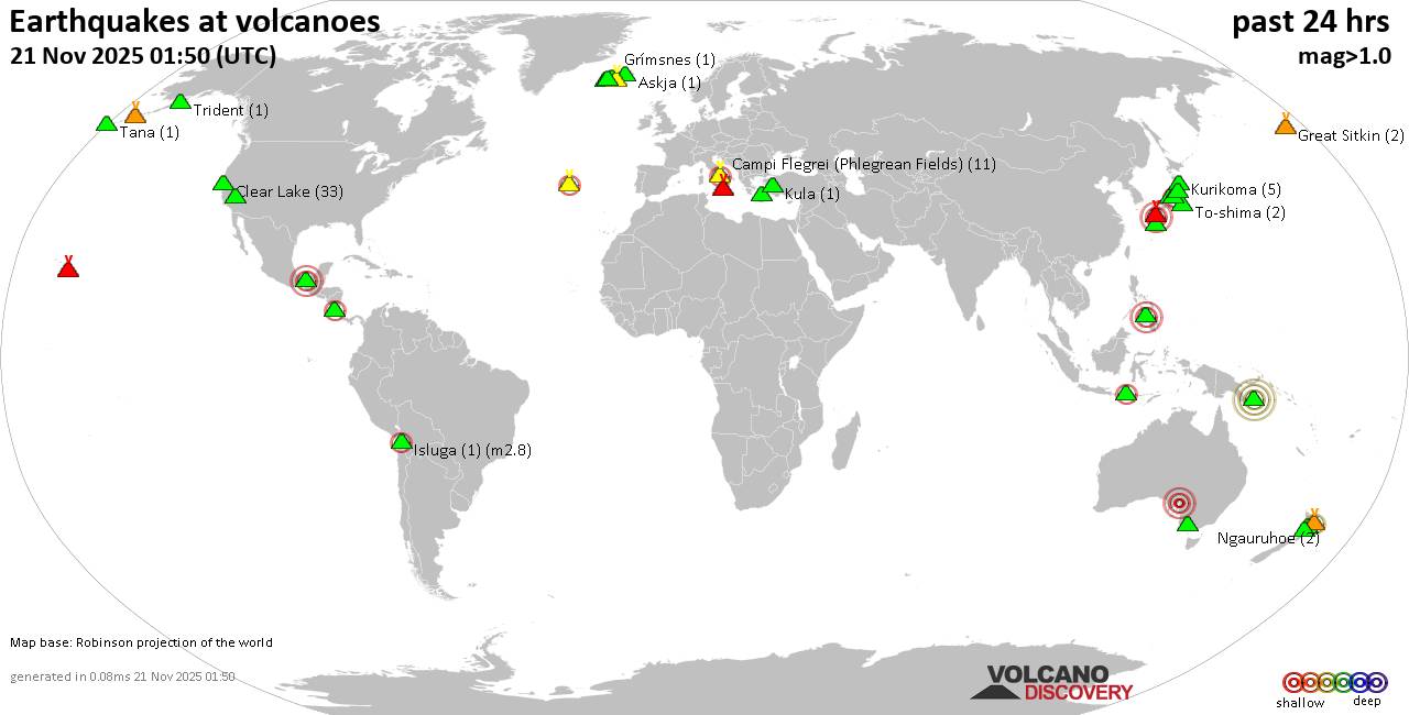
World map showing volcanoes with shallow (less than 50 km) earthquakes within 20 km radius during the past 24 hours on 21 Nov 2025 Number in brackets indicate nr of quakes.

Quakes detected near: Akuseki-jima (2 quakes between mag 1.7-2.0), Bardarbunga (2 quakes between mag 1.2-3.0), Biliran (1 quake mag 2.6), Binuluan (1 quake mag 1.6), Brennisteinsfjöll (2 quakes between mag 0.8-1.1), Campi Flegrei (Phlegrean Fields) (7 quakes between mag 0.1-1.3)
Clear Lake (34 quakes between mag 0.2-1.9), Coso (2 quakes between mag 1.4-1.9), Don Joao de Castro Bank (1 quake mag 2.5), El Chichón (27 quakes between mag 1.7-2.9), Eldey (7 quakes between mag 0.7-2.1), Fagradalsfjall (1 quake mag 1.2), Galeras (1 quake mag 3.0), Haku-san (3 quakes between mag 0.8-1.4), Katla (8 quakes between mag 0.4-1.9), Kilauea (2 quakes between mag 1.2-2.0), Kolumbo (1 quake mag 1.7), Krafla (2 quakes between mag 0.3-1.3), Krísuvík (12 quakes between mag 0.2-2.2), Kuchinoshima (2 quakes between mag 2.4-2.8), Ljósufjöll (4 quakes between mag 0.7-1.0), Los Humeros (1 quake mag 3.0), Mauna Kea (1 quake mag 1.7), Maunaloa (1 quake mag 1.8), Nantai (1 quake mag 1.1), Nejapa-Miraflores (1 quake mag 3.0), Nipesotsu-Maruyama (4 quakes between mag 0.9-2.7), Norikura (9 quakes between mag 0.1-2.8), Ontake-san (7 quakes between mag 0.2-2.1), Osore-yama (1 quake

Click this link to continue reading the article on the source website.