RSS feed source: Volcano Discovery.com--Global earthquake monitor

Tuesday, Nov 25, 2025 00:24 | 13 hours ago | By: EarthquakeMonitor

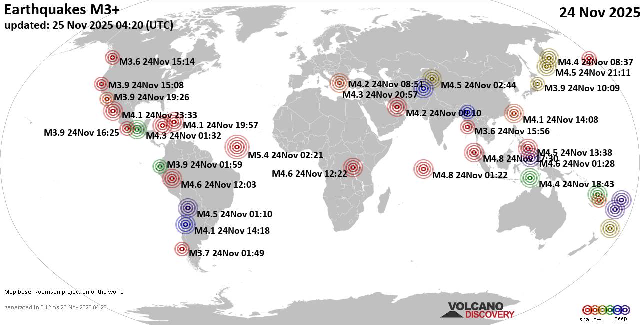
Worldwide earthquakes above magnitude 3 during the past 24 hours on 25 Nov 2025

Summary: 1 quake 5.0+, 37 quakes 4.0+, 138 quakes 3.0+, 317 quakes 2.0+ (493 total)
Magnitude 5+: 1 earthquake
Magnitude 4+: 37 earthquakes
Magnitude 3+: 138 earthquakes
Magnitude 2+: 317 earthquakes
No quakes of magnitude 6 or higherTotal seismic energy estimate: 2 x 10¹³ joules (5.53 gigawatt hours, equivalent to 4756 tons of TNT or 0.3 atomic bombs!) | equivalent to ONE quake of magnitude 5.7 learn more10 largest earthquakes in the world (24 Nov 2025)#1: Mag 5.4 Central Mid-Atlantic RidgeMonday, Nov 24, 2025, at 12:21 am (GMT -2) – #2: Mag 4.8 Kabupaten Bener Meriah, 33 km south of Bireun, IndonesiaTuesday, Nov 25, 2025, at 12:30 am (GMT +7) – #3: Mag 4.8 Indian Ocean, British Indian Ocean TerritoryMonday, Nov 24, 2025, at 06:22 am (GMT +5) – #4: Mag 4.7 South Pacific Ocean, 107 km east of Namuka Island, Eastern, FijiMonday, Nov 24, 2025, at 10:29 am (GMT -12) – #5: Mag 4.6 106 km southwest of Cruzeiro do Sul, Cruzeiro do Sul, Acre, BrazilMonday, Nov 24, 2025, at 07:03 am (GMT -5) – #6: Mag 4.6 27 km southwest of Bukavu, South Kivu Province, Democratic Republic of the CongoMonday, Nov 24, 2025, at 02:22 pm (GMT +2) –

Click this link to continue reading the article on the source website.

RSS feed source: Volcano Discovery.com--Global earthquake monitor

CHICAGO – Preliminary flood risk information and updated Flood Insurance Rate Maps (FIRMs) are available for review by residents and business owners in Hillsdale County, MI. Property owners are encouraged to review the latest information to learn about local flood risks and potential future flood insurance requirements. Community stakeholders can identify any concerns or questions about the information provided and participate in the 90-day appeal and comment period.

The 90-day appeal period began on October 31, 2025. The preliminary maps and changes from current maps may be viewed online at the FEMA Flood Map Changes Viewer: http://msc.fema.gov/fmcv.

The updated maps were produced in coordination with local, state, and FEMA officials. Significant community review of the maps has already taken place, but before the maps become final, community stakeholders can identify any concerns or questions about the information provided and submit appeals or comments. Contact your local floodplain administrator to do so.

Appeals must include technical information, such as hydraulic or hydrologic data, to support the claim.Appeals cannot be based on the effects of proposed projects or projects started after the study is in progress.If property owners see incorrect information that does not change the flood hazard information, such as a missing or misspelled road name in the Special Flood Hazard Area or an incorrect corporate boundary, they can submit a written comment.

The next step in the mapping process is the resolution of all comments and appeals. Once they are resolved, FEMA will notify communities of the effective date of the final maps.

For more information about the flood maps:

Use a live chat service about flood maps at http://go.usa.gov/r6C (just click on the “Live Chat” icon during operating hours).Contact a FEMA Map Specialist by telephone toll-free at 1-877-FEMA-MAP (1-877-336-2627) or by email at [email protected].

Most homeowner’s insurance policies do not cover flooding. Learn more about your flood insurance options by talking with your insurance agent and visiting www.FloodSmart.gov.

For more information, contact the FEMA Mapping Team at [email protected].

Click this link to continue reading the article on the source website.