RSS feed source: Volcano Discovery.com--Global earthquake monitor

Mon, 11 Aug 2025, 04:07 | BY: EARTHQUAKEMONITOR

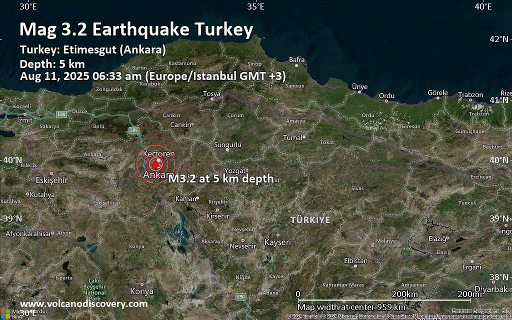
Turkey’s Disaster and Emergency Management Authority (AFAD) reported a magnitude 3.2 quake in Turkey near Ankara, 33 minutes ago. The earthquake hit early morning on Monday, August 11th, 2025, at 6:33 am local time at a very shallow depth of 4.70 km. Magnitude and other quake parameters can still change in the coming hours as the agency continues to process seismic data.
Our monitoring service identified a second report from the Kandilli Oservatory and Earthquake Research Institute in Istanbul (KOERI-RETMC) which listed the quake at magnitude 3.4. A third agency, the European-Mediterranean Seismological Centre (EMSC), reported the same quake at magnitude 3.2.
Based on the preliminary seismic data, the quake should not have caused any significant damage, but was probably felt by many people as light vibration in the area of the epicenter.
Weak shaking might have been felt in Ankara (pop. 3,517,200) located 5 km from the epicenter, and Cankaya (pop. 792,200) 6 km away.
Other towns or cities near the epicenter where the quake might have been felt as very weak shaking include Kizilcasar (pop. 8,600) located 13 km from the epicenter, Incek (pop. 5,600) 16 km away, Dumlupinar (pop. 4,500) 25 km away, Akyurt (pop. 26,600) 34 km away, and Kazan (pop. 23,900) 35 km away. In Elmadag (pop. 25,400, 37 km away), Cubuk

Click this link to continue reading the article on the source website.

RSS feed source: Volcano Discovery.com--Global earthquake monitor

Background:

Volcán Popocatépetl, whose name is the Aztec word for smoking mountain, towers to 5426 m 70 km SE of Mexico City to form North America’s 2nd-highest volcano.  The glacier-clad stratovolcano contains a steep-walled, 250-450 m deep crater.  The generally symmetrical volcano is modified by the sharp-peaked Ventorrillo on the NW, a remnant of an earlier volcano. 
At least three previous major cones were destroyed by gravitational failure during the Pleistocene, producing massive debris-avalanche deposits covering broad areas south of the volcano.  The modern volcano was constructed to the south of the late-Pleistocene to Holocene El Fraile cone.  Three major plinian eruptions, the most recent of which took place about 800 AD, have occurred from Popocatépetl since the mid Holocene, accompanied by pyroclastic flows and voluminous lahars that swept basins below the volcano.  Frequent historical eruptions, first recorded in Aztec codices, have occurred since precolumbian

Click this link to continue reading the article on the source website.

RSS feed source: Volcano Discovery.com--Global earthquake monitor

<!–div style="font-size:14px;text-align:center;border:3px solid blue;border-radius:5px;padding:3px;margin:5px;background:#eee"><a href="https://www.volcanoesandearthquakes.com/app/volcano-report.php?volcanoId=44" style="text-decoration:none" target="_blank" rel="noopener noreferrer nofollow" title="Share a volcano (activity) report, submit a photo or other interesting news!” onclick=”window.open(this.href,’Volcano Report’,’status=0,toolbar=0,location=0,directories=0,menubar=0,resizable=1,scrollbars=1,height=500,width=450′);return false”>Send Volcano Report</div–> Stratovolcano 3676 m (12,060 ft)
East Java, Indonesia, -8.11°S / 112.92°E
Current status: erupting (4 out of 5) Semeru volcano eruptions:
1818, 1829, 1830, 1832, 1836, 1838, 1842, 1844, 1845, 1848, 1849(?), 1851, 1856, 1857, 1865, 1866(?), 1887, 1887, 1888, 1889-91, 1892, 1893, 1893-94, 1895, 1896, 1897, 1899, 1899, 1900, 1901, 1903, 1904, 1905, 1907, 1908, 1909-10, 1910-11, 1911, 1912, 1913, 1941-42, 1945, 1946, 1946-47, 1950-64, 1967-ongoing
Typical eruption style
Explosive. Near constant strombolian activity, occasionally stronger explosions, lava flows and pyroclastic flows.

Click this link to continue reading the article on the source website.